METAR & TAF KDZB
Current METAR
Observed 04:15Z
KDZB 270415Z AUTO 16003KT 7SM CLR 26/19 A3000 RMK AO2 T02610186
- Wind
- 160° @ 3 kt
- Visibility
- 7 SM
- Temp / Dew
- 26°C / 19°C
- Altimeter
- 30.00 inHg
- Clouds
- CLR
- Density alt
- 2,576 ft
- Ceiling
- Unlimited
- Rules
- VFR
Airport info & contacts
Manager on record, flight service, ARTCC, attendance schedule and pattern altitude — published by the FAA and refreshed every 28 days.
Location
- From city
- 0 NM N
- VFR sectional
- SAN ANTONIO
- ARTCC
- ZHU · HOUSTON
- NOTAM facility
- SJT (NOTAM-D)
Airport manager
- Name
- LOUIS JENNINGS
- Phone
- 830-598-6386
- Address
- 112 S. DAKOTA, HORSESHOE BAY TX 78657
Flight service · Hours
- FSS SJT
- SAN ANGELO1-800-WX-BRIEF
- Attendance
- 0700-1900
Frequencies
Tap any row to copy the frequency to your clipboard.
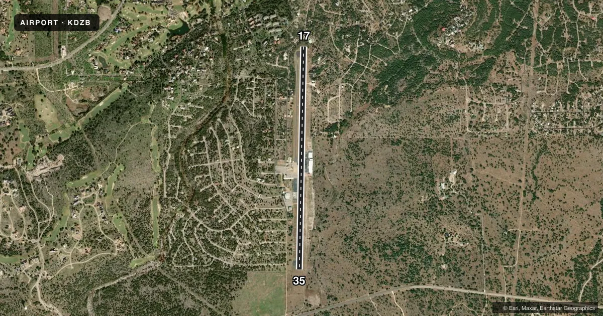
Runways & pattern
Full pagePattern entry · RWY 17
LEFT TRAFFICRunway end performance
| End | TORA | TODA | ASDA | LDA | VGSI | Approach lights | Obstruction |
|---|---|---|---|---|---|---|---|
| 35 | — | — | — | — | — | — | 41', tree, 900' from thr, 87' R of cntrln, slope 17 |
Declared distances in feet. TORA = takeoff run available, TODA = takeoff distance, ASDA = accelerate-stop, LDA = landing distance.
Airport sketch
Runways drawn to scale from FAA survey coordinates, rendered over satellite imagery. Not for navigation.
Approaches & charts
Services on the field
Fuel grades, oxygen, maintenance, ramp storage and lighting — as declared to the FAA by the airport operator.
Fuel & services
- Fuel
- 100LLA+
- Oxygen (bottled)
- HIGH/LOW
- Oxygen (bulk)
- HIGH/LOW
Ramp & ground
- Transient storage
- Tie-down
- Hangar
- Landing fee
- Yes
- Customs
- Not available
- Lighting schedule
- SEE RMK
- Beacon schedule
- SEE RMK
- Beacon
- White / Green (civil land)(WG)
- Wind indicator
- Yes
- Segmented circle
- No
Fuel & FBOs
Cheapest 100LL and Jet A on the field and nearby. Always confirm with the FBO before taxi.
Airport notes
Surface conditions, obstructions, local procedures, lighting outages and other notes published with each FAA cycle.
General notes
- DEER INVOF OF RWY.
- RWY 17 FT DROP OFF.
- FOR CD CTC HOUSTON ARTCC AT 281-230-5622.
- TGL AND TRNG FLTS PROHIBITED.
- RWY 17 PREFERRED FOR DEP.
- RWY 17, 35 FT PLINE, 375 FT R OF CNTRLN, PARL TO RWY 17 END NORTH 3600 FT.
Lighting notes
- ROTG BCN OPRS 24/7.
- HIRL RWY 17/35 PRESET LOW INTST; TO INCR INTST ACTVT - CTAF.
Approach & departure obstructions
- 176 FT TWR 5 FT DSTC, 82 FT R.
- 354 FT RISING TRRN 0-200 FT DSTC 204 FT L.
- 35RIGHT TFC NOT MKD ON GND.
- 17APCH SLOPE 0:1 TO DSPLCD THR; 10 FT STONE WALL 190 FT R. 50:1 BASED ON STRAIGHT OUT.
VFR map & nearby airports
VFR sectional. Tap any ICAO chip to open that airport.
Key facts · KDZB
Answer card- ICAO
- KDZB
- Name
- HORSESHOE BAY RESORT
- Location
- HORSESHOE BAY, TEXAS
- Elevation
- 1,093 ft MSL
- Traffic pattern altitude
- 2,093 ft MSL (1,000 AGL)
- Control tower
- Non-towered (use CTAF)
- Total runways
- 1
- Longest runway
- 17/35 · 5,977 ft
- Published ILS approaches
- 0
- Published frequencies
- 2
- Magnetic variation
- 7°
- Current flight rules
- VFR
- Current wind
- 160° at 3 kt
- Favored runway now
- RWY 17
Horseshoe Bay Resort Airport sits in Horseshoe Bay, Texas. The field elevation is 1,093 ft MSL. It has one asphalt runway, 17/35, at 5,977 ft. There is no control tower. CTAF and UNICOM are both 122.8. No ILS approaches are published.
The pattern altitude is not published. Use 1,000 ft AGL for light piston operations unless the current Chart Supplement says otherwise. The on-field FBO is Horseshoe Bay Resort Jet Center. It carries 100LL and Jet A Prist. Runway 17 is the preferred departure runway. The field also has a few operational items that matter on a first visit. Touch-and-go and training flights are prohibited. Deer are reported in the vicinity of the runway. Runway 17 has lighting that starts at low intensity. Use the CTAF to increase intensity. There is also a power line, a stone wall near the 17 approach path and rising terrain near the 35 end. Check the current Chart Supplement before you go if you need the latest on any local procedures or restrictions.