METAR & TAF 88R
88R does not publish a METAR.
Showing the nearest reporting station: KRYW (LAGO VISTA TX/RUSTY ALLEN) · 8.0 NM away. Conditions at 88R may differ.
METAR · KRYW
Observed 19:35Z
KRYW 271935Z AUTO 19005KT 10SM CLR 34/20 A3000 RMK AO2 T03380199
- Wind
- 190° @ 5 kt
- Visibility
- 10 SM
- Temp / Dew
- 34°C / 20°C
- Altimeter
- 30.00 inHg
- Clouds
- CLR
- Density alt
- 3,210 ft
- Ceiling
- Unlimited
- Rules
- VFR
Airport info & contacts
Manager on record, flight service, ARTCC, attendance schedule and pattern altitude — published by the FAA and refreshed every 28 days.
Location
- From city
- 2 NM E
- VFR sectional
- SAN ANTONIO
- ARTCC
- ZHU · HOUSTON
- NOTAM facility
- SJT (NOTAM-D)
Airport manager
- Name
- BOARD OF DIRECTORS
- Phone
- 830-201-3111
- Address
- 111 PIPER LANE, SPICEWOOD TX 78669
Flight service · Hours
- FSS SJT
- SAN ANGELO1-800-WX-BRIEF
- Attendance
- Unattended
Frequencies
Tap any row to copy the frequency to your clipboard.
Runways & pattern
Full pagePattern entry · RWY 17
LEFT TRAFFICRunway end performance
| End | TORA | TODA | ASDA | LDA | VGSI | Approach lights | Obstruction |
|---|---|---|---|---|---|---|---|
| 17 | — | — | — | — | — | — | 30', tree, 201' from thr, 0' R of cntrln, slope 0 |
| 35 | — | — | — | — | — | — | 12', trees, 230' from thr, 115' R of cntrln, slope 2 |
Declared distances in feet. TORA = takeoff run available, TODA = takeoff distance, ASDA = accelerate-stop, LDA = landing distance.
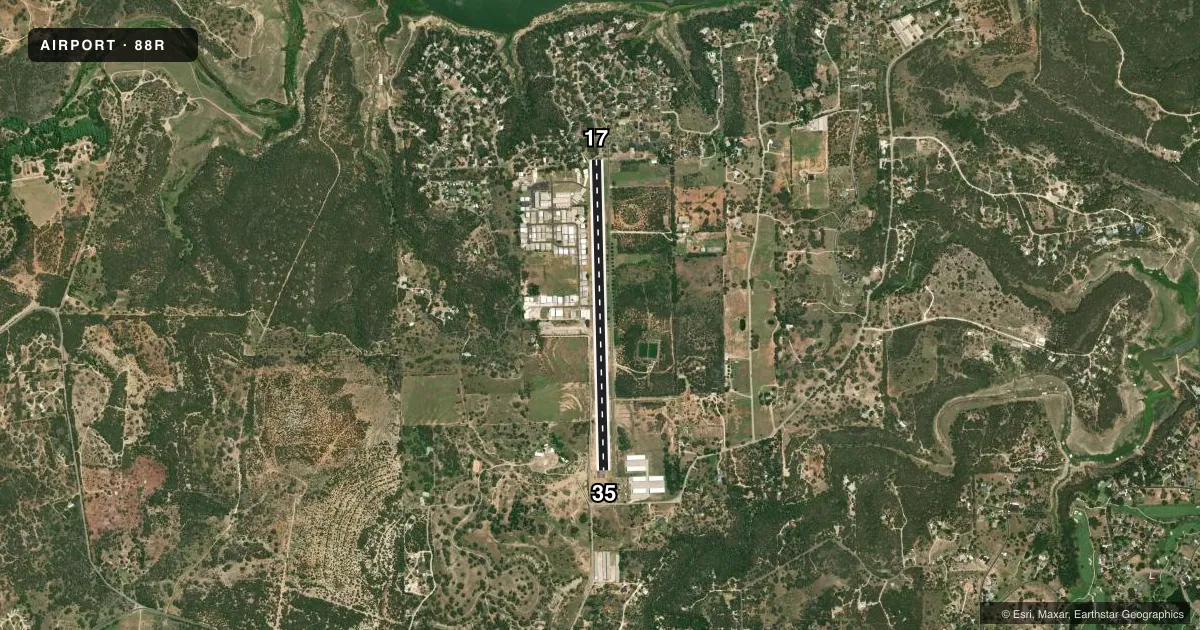
Airport sketch
Runways drawn to scale from FAA survey coordinates, rendered over satellite imagery. Not for navigation.
Approaches & charts
Services on the field
Fuel grades, oxygen, maintenance, ramp storage and lighting — as declared to the FAA by the airport operator.
Fuel & services
- Fuel
- 100LLA
- Airframe repair
- Not available
- Power plant repair
- Not available
- Other services
- INSTR,SURV
Ramp & ground
- Transient storage
- Tie-down
- Wind indicator
- Yes
- Segmented circle
- No
Fuel & FBOs
Cheapest 100LL and Jet A on the field and nearby. Always confirm with the FBO before taxi.
Airport notes
Surface conditions, obstructions, local procedures, lighting outages and other notes published with each FAA cycle.
General notes
- DEER ON & INVOF ARPT.
- ARPT CLSD AT NGT EXC FOR HEL, MEDEVAC & MIL FLTS.
- ARPT CLSD TO JET & TURBO JET ACFT, EXC FOR VERY LIGHT JETS.
- ARPT CLSD TO TGL, ULTRALIGHTS & HANG GLDRS.
- NO LINE OF SIGHT BTN RWY ENDS.
- RWY 17 - CALM WIND RWY
- ROTORCRAFT REMAIN ABV 500 AGL N OF RWY 17 TO AVOID RESIDENTIAL AREA.
- ROTORCRAFT PRACTICE & AUTOROTATION PROHIBITED.
- ROTORCRAFT ARR & DEP FLY DCTLY TO & FM PRKG TO AVOID UNNEC LOW-LEVEL TXG.
- FOR CD CTC AUSTIN APCH AT 512-369-7865.
Approach & departure obstructions
- 1725 FT TREES 0-199 FT DSTC ACRS APCH.
- 3510 FT RISING TRRN 35-125 FT LEFT OF CNTRLN AT THR.
- 17OBSTRUCTION CLEARANCE SLOPE 10:1 T0 DSPLCD THLD OVR 26 FT BLDG, 270 FT DSTC, 113 FT R.
VFR map & nearby airports
VFR sectional. Tap any ICAO chip to open that airport.
Key facts · 88R
Answer card- ICAO
- 88R
- Name
- SPICEWOOD
- Location
- SPICEWOOD, TEXAS
- Elevation
- 830 ft MSL
- Traffic pattern altitude
- 1,830 ft MSL (1,000 AGL)
- Control tower
- Non-towered (use CTAF)
- Total runways
- 1
- Longest runway
- 17/35 · 4,185 ft
- Published ILS approaches
- 0
- Published frequencies
- 2
- Magnetic variation
- 7°
- Current flight rules
- VFR
- Current wind
- 190° at 5 kt
- Favored runway now
- RWY 17
Spicewood Airport (88R) is in Spicewood, Texas. The field elevation is 830 ft MSL. It has one runway. Runway 17/35 is 4,185 ft long with an asphalt surface. There is no control tower, so use CTAF 122.8 for local traffic. UNICOM is also on 122.8 for airport traffic calls. No ILS approaches are published here.
The published pattern altitude is not listed. For light piston operations, use the standard 1,000 ft AGL pattern unless the current FAA Chart Supplement says otherwise. Spicewood Aviation is on the field. It carries 100LL. For clearance delivery, contact Austin Approach at 512-369-7865 before departure if you need IFR handling.
The remarks matter here. Runway 17 is the calm wind runway. The airport is closed at night except for helicopters, medevac and military flights. It is also closed to tailwheel, ultralights, hang gliders, jet aircraft and turbojets except very light jets. Watch the terrain and obstructions. There is rising terrain near the threshold of runway 35. There are trees and a building affecting the runway 17 approach path. Deer are reported on and near the airport. There is no line of sight between runway ends. A careful radio scan and good situational awareness help on the ground and in the pattern.