METAR & TAF 2KL
2KL does not publish a METAR.
Showing the nearest reporting station: KDZB (HORSESHOE BAY RESORT) · 5.1 NM away. Conditions at 2KL may differ.
METAR · KDZB
Observed 13:35Z
KDZB 271335Z AUTO 00000KT 7SM CLR 26/21 A3001 RMK AO2 T02590213
- Wind
- 000° @ 0 kt
- Visibility
- 7 SM
- Temp / Dew
- 26°C / 21°C
- Altimeter
- 30.01 inHg
- Clouds
- CLR
- Density alt
- 2,267 ft
- Ceiling
- Unlimited
- Rules
- VFR
Airport info & contacts
Manager on record, flight service, ARTCC, attendance schedule and pattern altitude — published by the FAA and refreshed every 28 days.
Location
- From city
- 1 NM NE
- VFR sectional
- SAN ANTONIO
- ARTCC
- ZHU · HOUSTON
- NOTAM facility
- SJT (NOTAM-D)
Airport manager
- Name
- SPENCER PIPPEN
- Phone
- 408-564-9954
- Address
- 101 DEER DR, SUNRISE BEACH TX 78643
Flight service · Hours
- FSS SJT
- SAN ANGELO1-800-WX-BRIEF
- Attendance
- Unattended
Frequencies
Tap any row to copy the frequency to your clipboard.
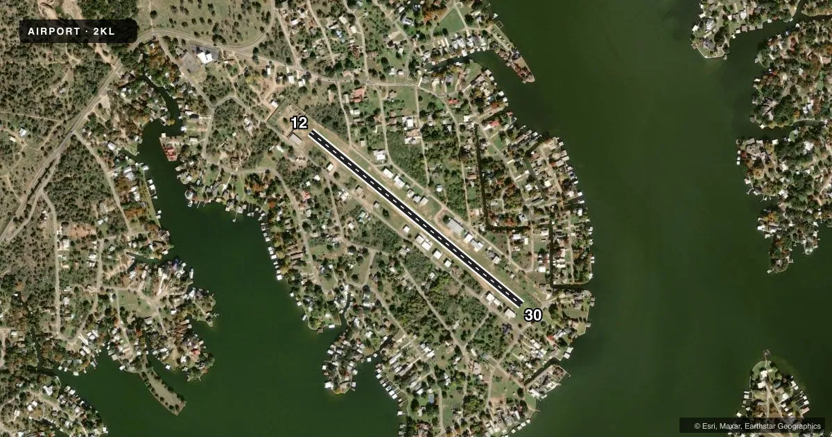
Runways & pattern
Full pagePattern entry · RWY 12
LEFT TRAFFICRunway end performance
| End | TORA | TODA | ASDA | LDA | VGSI | Approach lights | Obstruction |
|---|---|---|---|---|---|---|---|
| 12 | — | — | — | — | — | — | 23', tree, 330' from thr, 78' R of cntrln, slope 14 |
| 30 | — | — | — | — | — | — | 55', tree, 288' from thr, 150' R of cntrln, slope 5 |
Declared distances in feet. TORA = takeoff run available, TODA = takeoff distance, ASDA = accelerate-stop, LDA = landing distance.
Airport sketch
Runways drawn to scale from FAA survey coordinates, rendered over satellite imagery. Not for navigation.
Approaches & charts
Services on the field
Fuel grades, oxygen, maintenance, ramp storage and lighting — as declared to the FAA by the airport operator.
Fuel & services
- Fuel
- Not available
- Airframe repair
- Major
- Power plant repair
- Major
Ramp & ground
- Transient storage
- Tie-down
- Landing fee
- No fee published
- Customs
- Not available
- Lighting schedule
- SEE RMK
- Wind indicator
- Lighted
- Segmented circle
- Yes
Fuel & FBOs
Cheapest 100LL and Jet A on the field and nearby. Always confirm with the FBO before taxi.
Airport notes
Surface conditions, obstructions, local procedures, lighting outages and other notes published with each FAA cycle.
General notes
- 20-30 FT TREES ALG BOTH SIDES OF RWY 75 FT EACH SIDE OF RWY CNTRLN.
- TREES IN APCH AREA & HNGRS WI 60 FT OF RWY.
- NMRS DEER ON & INVOF RWY. NGT OPNS NOT RCMDD.
- NO TOUCH AND GO LDG OPS.
- TRANSIENT PRKG WEST END OF RWY BY OPEN HGR. PKG LMTD TO 72 HRS.
- EMERG HELIPAD LCTD EAST OF WIND SOCK & SEGMENTED CRC.
- RWY 12/30 IRRIGATED AFT 2230 NGTLY.
- FOR CD CTC HOUSTON ARTCC AT 281-230-5622.
Lighting notes
- DUSK-2230
Approach & departure obstructions
- 12THR MKD WITH WHITE TIRES.
- 30THLD MKD WITH RED LGTS.
Other notes
- FOR ACFT SVC CALL 512-755-0399.
- EXISTED PRIOR TO THE FAA ACT.
VFR map & nearby airports
VFR sectional. Tap any ICAO chip to open that airport.
Key facts · 2KL
Answer card- ICAO
- 2KL
- Name
- SUNRISE BEACH
- Location
- SUNRISE BEACH VILLAGE, TEXAS
- Elevation
- 854 ft MSL
- Traffic pattern altitude
- 1,854 ft MSL (1,000 AGL)
- Control tower
- Non-towered (use CTAF)
- Total runways
- 1
- Longest runway
- 12/30 · 2,649 ft
- Published ILS approaches
- 0
- Published frequencies
- 1
- Magnetic variation
- 7°
- Current flight rules
- VFR
- Current wind
- 000° at 0 kt
- Favored runway now
- –
Sunrise Beach Airport sits in Sunrise Beach Village, Texas. Field elevation is 854 ft MSL. The airport has one runway. Runway 12/30 is 2,649 ft of turf. There is no control tower. CTAF is 122.9. No ILS approaches are published.
Pattern altitude is not published. Use standard 1,000 ft AGL unless the current FAA Chart Supplement or the airport operator says otherwise. The field has no on-field FBOs listed. For aircraft service, the published number is 512-755-0399. Lighting is available from dusk to 2230. The runway 30 threshold is marked with red lights. The runway 12 threshold is marked with white tires.
This is a short turf strip with trees along both sides and more trees in the approach area. Hangars sit close to the runway. Deer are reported on and near the runway. Night operations are not recommended. No touch-and-go operations are permitted. Transient parking is at the west end of the runway by the open hangar. Parking is limited to 72 hours. For clearance delivery, contact Houston ARTCC at 281-230-5622. First-time pilots should plan a careful stabilized approach. Keep the tree line in mind. Verify current field conditions before departure.