METAR & TAF KBMQ
Current METAR
Observed 14:53Z
KBMQ 271453Z AUTO VRB05KT 10SM CLR 28/21 A3002 RMK AO2 SLP147 T02780206 51005
- Wind
- VAR @ 5 kt
- Visibility
- 10 SM
- Temp / Dew
- 28°C / 21°C
- Altimeter
- 30.02 inHg
- Clouds
- CLR
- Density alt
- 3,027 ft
- Ceiling
- Unlimited
- Rules
- VFR
Airport info & contacts
Manager on record, flight service, ARTCC, attendance schedule and pattern altitude — published by the FAA and refreshed every 28 days.
Location
- From city
- 1 NM SW
- VFR sectional
- SAN ANTONIO
- ARTCC
- ZHU · HOUSTON
- NOTAM facility
- BMQ (NOTAM-D)
Airport manager
- Name
- ADRIANNE FEILD
- Phone
- 512-756-6655
- Address
- PO BOX 1369, BURNET TX 78611
Flight service · Hours
- FSS SJT
- SAN ANGELO1-800-WX-BRIEF
- Attendance
- 0800-1800
Frequencies
Tap any row to copy the frequency to your clipboard.
Runways & pattern
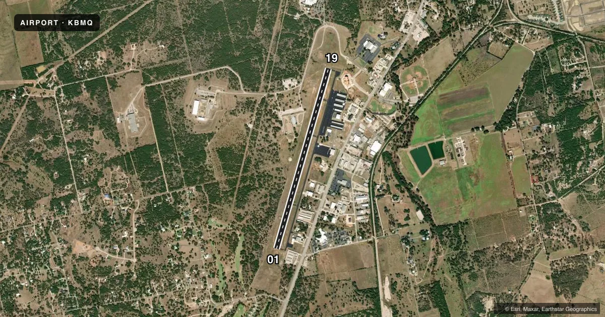
Full pagePattern entry · RWY 01
RIGHT TRAFFICRunway end performance
| End | TORA | TODA | ASDA | LDA | VGSI | Approach lights | Obstruction |
|---|---|---|---|---|---|---|---|
| 01 | — | — | — | — | PAPI 4-box left(3°) | — | 32', pline, 1300' from thr, 0' R of cntrln, slope 34 |
| 19 | — | — | — | — | PAPI 4-box left(3.03°) | — | 40', trees, 1225' from thr, 440' R of cntrln, slope 25 |
Declared distances in feet. TORA = takeoff run available, TODA = takeoff distance, ASDA = accelerate-stop, LDA = landing distance.
Airport sketch
Runways drawn to scale from FAA survey coordinates, rendered over satellite imagery. Not for navigation.
Approaches & charts
Services on the field
Fuel grades, oxygen, maintenance, ramp storage and lighting — as declared to the FAA by the airport operator.
Fuel & services
- Fuel
- 100LLA
- Oxygen (bottled)
- Not available
- Oxygen (bulk)
- Not available
- Airframe repair
- Major
- Power plant repair
- Major
- Other services
- AMB,AVNCS,INSTR,RNTL
Ramp & ground
- Transient storage
- Tie-down
- Landing fee
- No fee published
- Customs
- Not available
- Lighting schedule
- SEE RMK
- Beacon schedule
- SS-SR
- Beacon
- White / Green (civil land)(WG)
- Wind indicator
- Lighted
- Segmented circle
- Yes
Fuel & FBOs
Cheapest 100LL and Jet A on the field and nearby. Always confirm with the FBO before taxi.
Airport notes
Surface conditions, obstructions, local procedures, lighting outages and other notes published with each FAA cycle.
General notes
- DEER INVOF AIRPORT.
- RWY 19 PREFERRED CALM WIND RWY.
- FOR CD CTC HOUSTON ARTCC AT 281-230-5622.
Lighting notes
- DUSK-DAWN. REIL RWY 01 & 19; PAPI RWY 01 & 19; MIRL RWY 01/19 PRESET LOW INTST; TO INCR INTST & ACTVT - CTAF.
Other notes
- PRE-DATES THE ACT.
- 1FOR ARPT ATTENDANT CALL 512-756-6655.
- MANAGERADMIN SERVICES/AMGR 512-715-3214.
- MANAGERFBO.
VFR map & nearby airports
VFR sectional. Tap any ICAO chip to open that airport.
Key facts · KBMQ
Answer card- ICAO
- KBMQ
- Name
- BURNET MUNI/KATE CRADDOCK FLD
- Location
- BURNET, TEXAS
- Elevation
- 1,283.4 ft MSL
- Traffic pattern altitude
- 2,283.4 ft MSL (1,000 AGL)
- Control tower
- Non-towered (use CTAF)
- Total runways
- 1
- Longest runway
- 01/19 · 5,001 ft
- Published ILS approaches
- 0
- Published frequencies
- 2
- Magnetic variation
- 3°
- Current flight rules
- VFR
- Current wind
- 000° at 5 kt
- Favored runway now
- RWY 01
KBMQ sits in Burnet, Texas. The field elevation is 1,283.4 ft MSL. It has one runway. Runway 01/19 is 5,001 ft long with asphalt pavement. There is no control tower. CTAF and UNICOM are both 122.8. No ILS approaches are published here.
Pattern altitude is not published. Use the standard 1,000 ft AGL pattern for light piston traffic unless the current Chart Supplement says otherwise. Runway 19 is the preferred calm wind runway. Deer are reported in the vicinity of the airport. Keep a sharp scan on taxi, takeoff and final. Lighting is dusk to dawn. The runway end identifier lights are on both ends. PAPI is installed on runways 01 and 19. Medium intensity runway lights on 01/19 are preset to low intensity. Use the common traffic advisory frequency to increase intensity and activate the lights.
Crosby Flying Services is on the field. It carries 100LL and Jet A. For airport attendant service, call the number in the Chart Supplement or the FBO directly. If you need clearance delivery, Houston ARTCC handles that side of the operation. This is a non-towered field. Listen up early and make your calls clean on 122.8.