METAR & TAF 2TX
2TX does not publish a METAR.
Showing the nearest reporting station: KILE (SKYLARK FLD) · 12.5 NM away. Conditions at 2TX may differ.
METAR · KILE
Observed 11:56Z
KILE 271156Z AUTO 17005KT 10SM CLR 24/ A2999 RMK AO2 SLP144 T0239 10278 20239 53001
- Wind
- 170° @ 5 kt
- Visibility
- 10 SM
- Temp / Dew
- —
- Altimeter
- 29.99 inHg
- Clouds
- CLR
- Density alt
- —
- Ceiling
- Unlimited
- Rules
- VFR
Airport info & contacts
Manager on record, flight service, ARTCC, attendance schedule and pattern altitude — published by the FAA and refreshed every 28 days.
Location
- From city
- 2 NM S
- VFR sectional
- SAN ANTONIO
- ARTCC
- ZFW · FORT WORTH
- NOTAM facility
- SJT (NOTAM-D)
Airport manager
- Name
- JEREMY HINTZ
- Phone
- 512-222-8893
- Address
- 15771 SOUTH I-35, SALADO TX 76571
Flight service · Hours
- FSS SJT
- SAN ANGELO1-800-WX-BRIEF
- Attendance
- Unattended
Frequencies
Tap any row to copy the frequency to your clipboard.
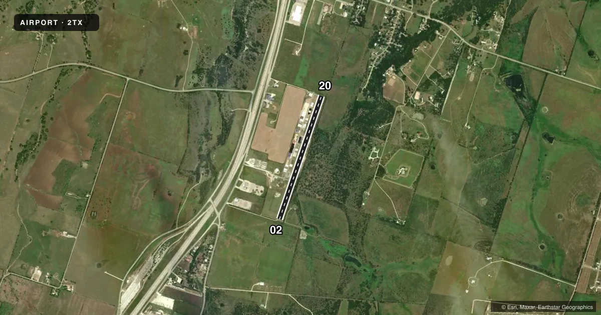
Runways & pattern
Full pagePattern entry · RWY 20
LEFT TRAFFICRunway end performance
| End | TORA | TODA | ASDA | LDA | VGSI | Approach lights | Obstruction |
|---|---|---|---|---|---|---|---|
| 02 | — | — | — | — | — | — | 10', pline, 338' from thr, 90' R of cntrln, slope 13 |
| 20 | — | — | — | — | — | — | 10', trees, 210' from thr, 125' R of cntrln, slope 1 |
Declared distances in feet. TORA = takeoff run available, TODA = takeoff distance, ASDA = accelerate-stop, LDA = landing distance.
Airport sketch
Runways drawn to scale from FAA survey coordinates, rendered over satellite imagery. Not for navigation.
Approaches & charts
Services on the field
Fuel grades, oxygen, maintenance, ramp storage and lighting — as declared to the FAA by the airport operator.
Fuel & services
- Fuel
- Not available
- Oxygen (bottled)
- Not available
- Oxygen (bulk)
- Not available
- Airframe repair
- Not available
- Power plant repair
- Not available
Ramp & ground
- Transient storage
- Not published
- Landing fee
- No fee published
- Wind indicator
- Yes
- Segmented circle
- No
Fuel & FBOs
Cheapest 100LL and Jet A on the field and nearby. Always confirm with the FBO before taxi.
Airport notes
Surface conditions, obstructions, local procedures, lighting outages and other notes published with each FAA cycle.
General notes
- FOR CD CTC FORT WORTH ARTCC AT 817-858-7584.
- TWO ANTENNAS 150 FT AGL & 250 AGL, 1/2 TO 3/4 MILE NE OF APCH END RWY 20.
Approach & departure obstructions
- 0230 FT TREES, 30 FT DSTC; 10 FT ROAD, 40 FT DSTC.
- 205 FT TREES, 35 FT DSTC, 120 FT R.
Other notes
- VFR ONLY
- MANAGERJERHINTZ@GMAIL.COM
VFR map & nearby airports
VFR sectional. Tap any ICAO chip to open that airport.
Key facts · 2TX
Answer card- ICAO
- 2TX
- Name
- SALADO
- Location
- SALADO, TEXAS
- Elevation
- 689 ft MSL
- Traffic pattern altitude
- 1,689 ft MSL (1,000 AGL)
- Control tower
- Non-towered (use CTAF)
- Total runways
- 1
- Longest runway
- 02/20 · 3,494 ft
- Published ILS approaches
- 0
- Published frequencies
- 1
- Magnetic variation
- 7°
- Current flight rules
- VFR
- Current wind
- 170° at 5 kt
- Favored runway now
- RWY 20
Salado Airport (2TX) sits in Salado, Texas. The field elevation is 689 ft MSL. It has one runway. Runway 02/20 is 3,494 ft long with an asphalt surface. There is no control tower. CTAF is 122.9. No ILS approaches are published here.
The pattern altitude is not published. Use the standard 1,000 ft AGL pattern unless the current Chart Supplement says otherwise. That puts the traffic pattern at 1,689 ft MSL based on the field elevation. Verify before you fly. The airport is VFR only. For clearance delivery, contact Fort Worth ARTCC at 817-858-7584.
There are no on-field FBOs listed in the facts. Contact the airport manager directly at jerhintz@gmail.com before arrival if you need current field details. Watch the ends of both runways. The published remarks call out trees near runway 02, trees near runway 20 and two antennas northeast of the approach end of runway 20. This is a small, non-towered field, so plan your self-announce calls early. Keep a close eye on traffic.