METAR & TAF KGRK
Current METAR
Observed 12:55Z
KGRK 271255Z AUTO 15007KT 10SM CLR 26/23 A2998 RMK AO2 SLP138 T02560229
- Wind
- 150° @ 7 kt
- Visibility
- 10 SM
- Temp / Dew
- 26°C / 23°C
- Altimeter
- 29.98 inHg
- Clouds
- CLR
- Density alt
- 2,504 ft
- Ceiling
- Unlimited
- Rules
- VFR
Airport info & contacts
Manager on record, flight service, ARTCC, attendance schedule and pattern altitude — published by the FAA and refreshed every 28 days.
Location
- From city
- 6 NM SW
- VFR sectional
- SAN ANTONIO
- ARTCC
- ZFW · FORT WORTH
- NOTAM facility
- GRK (NOTAM-D)
Airport manager
- Name
- MICHAEL WILSON
- Phone
- 254-501-8701
- Address
- 8101 S CLEAR CREEK RD, BOX C, KILLEEN TX 76549
Flight service · Hours
- FSS SJT
- SAN ANGELO1-800-WX-BRIEF
- Attendance
- ALL
Frequencies
Tap any row to copy the frequency to your clipboard.
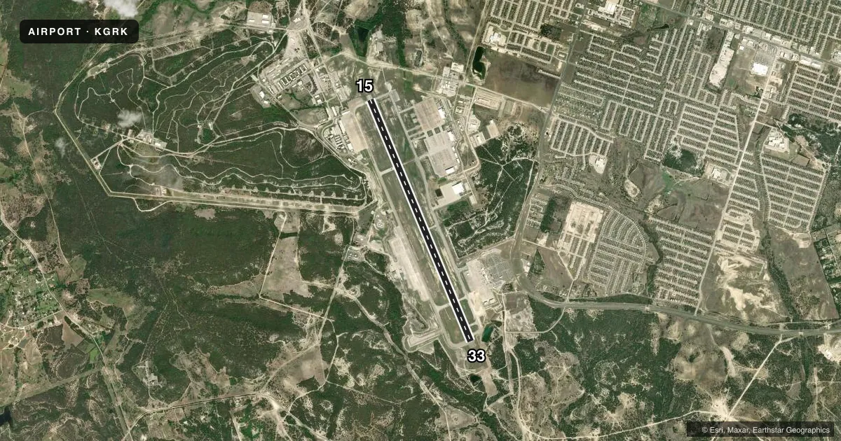
Runways & pattern
Full pagePattern entry · RWY 15
LEFT TRAFFICRunway end performance
| End | TORA | TODA | ASDA | LDA | VGSI | Approach lights | Obstruction |
|---|---|---|---|---|---|---|---|
| 15 | — | — | — | — | PAPI 4-box left(3°) | MALSR | — |
| 33 | — | — | — | — | PAPI 4-box left(3°) | MALSR | — |
Declared distances in feet. TORA = takeoff run available, TODA = takeoff distance, ASDA = accelerate-stop, LDA = landing distance.
Airport sketch
Runways drawn to scale from FAA survey coordinates, rendered over satellite imagery. Not for navigation.
Approaches & charts
ILS · 2
Services on the field
Fuel grades, oxygen, maintenance, ramp storage and lighting — as declared to the FAA by the airport operator.
Fuel & services
- Fuel
- A
Ramp & ground
- Transient storage
- Not published
- Customs
- Not available
- Lighting schedule
- SS-SR
- Beacon schedule
- SS-SR
- Beacon
- Split White / Green (military)(SWG)
- Wind indicator
- Yes
- Segmented circle
- No
Fuel & FBOs
Cheapest 100LL and Jet A on the field and nearby. Always confirm with the FBO before taxi.
Airport notes
Surface conditions, obstructions, local procedures, lighting outages and other notes published with each FAA cycle.
General notes
- CAUTION: EXTV COPTER OPR VCNTY FORT HOOD, SOME WO CONSPICUOUS MRK AND BLEND WITH TERRAIN.
- MIL-MISC: LTD PRK.
- MISC: WX VIS OBST RSTD S THRU NW.
- BEARING STRENGTH RWY 15/33: ST175 SBTT593 TRT840 TRT585.
- MIL-JASU: 1(AM32-95) LASS 1(TUG TMD-250) 1(ESSEX B809).
- MIL-FUEL: A++ PPR ONLY.
- TFC PAT: TFC PAT ALT LEFT AND RGT. ROTARY WING 1500 FT, UAS 2000 FT WEST TFC ONLY, FIXED WING 2500 FT, PURE JET/OVERHEAD 3000 FT.
- MISC: CLSD CIRCUIT TV OPR.
- MIL-MISC: ALL INBD PPR ACFT CTC PTD 20 MIN PRIOR TO LDG. BASE OPS FAX DSN 738-1930, C254-288-1930.
- CIV: PPR ALL CIVIL ACFT CTC AMGR.
- MIL-RSTD: PPR MIL RAMP DSN 738-9200/9209, C254-288-9200/9209, CIV RAMP (KFHRA) C254-501-8750.
- RSTD: TWY B FR TWY C TO E RSTD TO ACFT WITH WINGSPAN 200' OR LESS.
- MIL-MISC: PAR NOT AVBL (EXC EMERGENCY) FROM 0500-1300Z++.
- MIL-MISC: BASE OPS APVL FOR RAMP ACCESS.
- MIL-CSTMS/AG/IMG: CSTMS AVBL 72 HR PN RQR. DUR NML DUTY HR CTC PMO CSTMS DSN 737-3535/3508, C254-287-3535/3508, OT CTC BASE OPS DSN 738-9200, C254-288-9200.
- CAUTION: EXTV COPTER SOD OPS.
- MIL-CSTMS/AG/IMG: USDA AG INSPECTION NOT AVBL.
- MIL-RSTD: TWY B FROM TWY C TO AER 15 RSTD TO ACFT WITH AN ACN OF 24 OR LESS.
- MIL-MISC: 24 HR NOTICE RQR FOR LAV AND WATER SVC.
- MIL: BASE OPS FX DSN 738-1930, COM 254-288-1930.
- CIV: ARPT UNICOM FREQ 122.825 (KILLEEN RADIO).
- MIL-MISC: SPACE A PAX OPS PROHIBITED, INBOUND AND OUTBOUND.
- MIL-MISC: NO OFF AFLD TRANSIENT AIRCREW TRANSPORTATION AVBL.
- MIL-MISC: 50 FT FUEL SERVICE SAFETY ZONE ENFORCED DURING ALL REFUEL OPS.
- RSTD: TWY D AND TWY B FR C TO APCH END RWY 33 NOT AUTH FOR DOD ACFT RQR CLASS B RWY.
- CAUTION: EXTV UAS ACFT WITHIN CLASS D AIRSPACE AND BTN CLASS D AIRSPACE AND R6302.
- TFC PAT: UAS 2000' (WEST TFC ONLY).
- MISC - 50' FUEL SVC SAFETY ZONE ENFORCED DURING ALL REFUEL OPS. SPACE A PAX OPS PROH, INBD AND OUTBD. NO OFF AFLD TRAN AIRCREW TRANSPORTATION AVBL. WIDE BODY ACFT 180 DEG TURNS PROH ON RWY 15/33. WIDE BODY ACFT MOVEMENT ON THE SOUTH RAMP AUTH ONLY UNDER CONTROL OF FOLLOW-ME AND GROUND MARSHAL PERS.
- WIDE BODY ACFT 180 DEG TURNS ALLOWED ONLY ON CONC AREAS AT EACH EOR 15/33. WIDE BODY AIRCRAFT MOVEMENT ON THE SOUTH RAMP AUTHORIZED ONLY UNDER CONTROL OF FOLLOW-ME AND GROUND MARSHAL PERSONNEL.
- WATER TOWER 1182 FT E SIDE OF AIRFIELD.
- MIL-MISC: NO DE-ICE CAPABILITY.
Fuel notes
- ACIV: JET A AVBL 0400-2030. FOR SVC AFT HRS CALL 254-501-8750.
Runway surface & condition
- 15/33PCN NUMBER TAKEN FROM RGAAF AIRFIELD PAVEMENT ATIIP AAF-19-02 REPORT DATED 5 SEPTEMBER 2019
Other notes
- MANAGERCIVILIAN ARPT MANAGER. MIL CTC AFLD MGR, VERNON MCDANIEL, CELL-254-289-5628/ OFFICE-254-287-5102.
- MANAGERAIRFIELD MANAGER- BASE OPERATIONS. MWILSON@KILLEENTEXAS.GOV
- 15/33RWY 33 FIRST 1000 FT PEM REMAINING 8997 FT GRVD.
VFR map & nearby airports
VFR sectional. Tap any ICAO chip to open that airport.
Key facts · KGRK
Answer card- ICAO
- KGRK
- Name
- ROBERT GRAY AAF
- Location
- FORT HOOD (KILLEEN), TEXAS
- Elevation
- 1,015.2 ft MSL
- Traffic pattern altitude
- 2,015.2 ft MSL (1,000 AGL)
- Control tower
- Towered · 24
- Total runways
- 1
- Longest runway
- 15/33 · 9,997 ft
- Published ILS approaches
- 2
- Published frequencies
- 16
- Magnetic variation
- 4°
- Current flight rules
- VFR
- Current wind
- 150° at 7 kt
- Favored runway now
- RWY 15
Robert Gray AAF sits at Fort Hood near Killeen, Texas. Field elevation is 1,015.2 ft MSL. The airport has one runway, 15/33, which is 9,997 ft long. The tower is open 24 hours. There are 2 ILS approaches, one for runway 15 and one for runway 33. Pattern altitude is not published in the facts, so use the current Chart Supplement for the published pattern information before you go.
This is a military field with limited parking. Space available passenger operations are prohibited inbound and outbound. The field also has extensive helicopter activity in the area. Some aircraft blend into the terrain, so keep your scan active on arrival and departure. Visibility can be restricted from south through northwest. Precision approach radar is not available except for emergencies from 0500 to 1300 Zulu and beyond. If you are planning a civilian stop, the on-field FBO is Killeen Regional Airport. It carries JET_A.
For ground handling and ramp access, verify the current procedures with the airport operator or the FBO directly by phone before arrival. The military ramp requires prior permission. Taxiway restrictions also apply for some Department of Defense aircraft. This is a field where you want the latest briefing in hand before you launch.