METAR & TAF KRCK
KRCK does not publish a METAR.
Showing the nearest reporting station: KRWV (CALDWELL MUNI) · 16.3 NM away. Conditions at KRCK may differ.
METAR · KRWV
Observed 23:55Z
KRWV 262355Z AUTO 19009KT 10SM CLR 34/20 A2997 RMK AO2
- Wind
- 190° @ 9 kt
- Visibility
- 10 SM
- Temp / Dew
- 34°C / 20°C
- Altimeter
- 29.97 inHg
- Clouds
- CLR
- Density alt
- 2,806 ft
- Ceiling
- Unlimited
- Rules
- VFR
Airport info & contacts
Manager on record, flight service, ARTCC, attendance schedule and pattern altitude — published by the FAA and refreshed every 28 days.
Location
- From city
- 2 NM SE
- VFR sectional
- HOUSTON
- ARTCC
- ZHU · HOUSTON
- NOTAM facility
- CXO (NOTAM-D)
Airport manager
- Name
- JERALD BRUNSON
- Phone
- 512-760-6991
- Address
- 505 W. CAMERON, ROCKDALE TX 76567
Flight service · Hours
- FSS CXO
- MONTGOMERY COUNTY1-800-WX-BRIEF
- Attendance
- Unattended
Frequencies
Tap any row to copy the frequency to your clipboard.
Runways & pattern
Full pagePattern entry · RWY 17
LEFT TRAFFICRunway end performance
| End | TORA | TODA | ASDA | LDA | VGSI | Approach lights | Obstruction |
|---|---|---|---|---|---|---|---|
| 17 | — | — | — | — | — | — | 17', road, 201' from thr, 80' R of cntrln, slope 0 |
| 35 | — | — | — | — | — | — | 50', trees, 201' from thr, 112' R of cntrln, slope 0 |
Declared distances in feet. TORA = takeoff run available, TODA = takeoff distance, ASDA = accelerate-stop, LDA = landing distance.
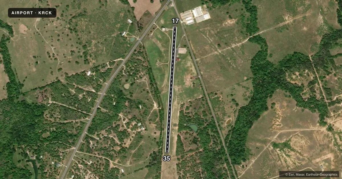
Airport sketch
Runways drawn to scale from FAA survey coordinates, rendered over satellite imagery. Not for navigation.
Approaches & charts
Services on the field
Fuel grades, oxygen, maintenance, ramp storage and lighting — as declared to the FAA by the airport operator.
Fuel & services
- Fuel
- 100LL
- Airframe repair
- Not available
- Power plant repair
- Not available
Ramp & ground
- Transient storage
- Tie-down
- Lighting schedule
- SS-SR
- Beacon schedule
- SS-SR
- Beacon
- White / Green (civil land)(WG)
- Wind indicator
- Lighted
- Segmented circle
- Yes
Fuel & FBOs
Cheapest 100LL and Jet A on the field and nearby. Always confirm with the FBO before taxi.
Airport notes
Surface conditions, obstructions, local procedures, lighting outages and other notes published with each FAA cycle.
General notes
- +40 FT ANT ON HGR E SIDE OF RWY.
- FOR CD CTC HOUSTON APCH AT 281-443-5844 TO CNL IFR CALL 281-443-5888.
Lighting notes
- ROTG BCN OTS INDEFLY.
Runway surface & condition
- 17/35NSTD LIRL - HOUSEHOLD TYPE FIXTURES, OPRG STATUS OF LGT UNKN. NSTD SPACING.
Approach & departure obstructions
- 174 FT FENCE, 0-199 FT DSTC, 125-50 FT L.
- 3550 FT TREES, 0-199 FT DSTC, 112 FT L.
- 17APCH SLOPE IS GTR THAN 45 DEG ANGLE.
Other notes
- MANAGERDIRECTOR OF PUBLIC WORKS/AMGR
VFR map & nearby airports
VFR sectional. Tap any ICAO chip to open that airport.
Key facts · KRCK
Answer card- ICAO
- KRCK
- Name
- H H COFFIELD RGNL
- Location
- ROCKDALE, TEXAS
- Elevation
- 474 ft MSL
- Traffic pattern altitude
- 1,474 ft MSL (1,000 AGL)
- Control tower
- Non-towered (use CTAF)
- Total runways
- 1
- Longest runway
- 17/35 · 2,962 ft
- Published ILS approaches
- 0
- Published frequencies
- 1
- Magnetic variation
- 6°
- Current flight rules
- VFR
- Current wind
- 190° at 9 kt
- Favored runway now
- RWY 17
H H Coffield Rgnl is in Rockdale, Texas. Field elevation is 474 ft MSL. The airport has one runway. Runway 17/35 is 2,962 ft long and asphalt. There is no control tower. CTAF is 122.9. No ILS approaches are published here.
The published pattern altitude is not listed, so use the standard 1,000 ft AGL pattern unless the current Chart Supplement says otherwise. That puts the traffic pattern at 1,474 ft MSL based on the field elevation. Coffield Regional Airport is the on-field FBO. It carries 100LL. Call ahead at (512) 446-2511 for current service details.
A few remarks matter here. The runway has nonstandard low-intensity lights with household-type fixtures. Their operating status is unknown. The rotating beacon is out of service indefinitely. There is also a fence near the 17 end and trees near the 35 end. A 40-foot antenna sits on the east side of the runway. The airport manager is the Director of Public Works and Airport Manager. For IFR coordination, Houston Approach handles clearance delivery. Verify current procedures before you go. This is a non-towered field, so plan your self-announce calls carefully and keep an eye on the runway ends.