METAR & TAF KRWV
Current METAR
Observed 13:15Z
KRWV 271315Z AUTO 22007KT 10SM BKN007 26/24 A3001 RMK AO2
- Wind
- 220° @ 7 kt
- Visibility
- 10 SM
- Temp / Dew
- 26°C / 24°C
- Altimeter
- 30.01 inHg
- Clouds
- BKN
- Density alt
- 1,693 ft
- Ceiling
- 700 ft AGL
- Rules
- IFR
Airport info & contacts
Manager on record, flight service, ARTCC, attendance schedule and pattern altitude — published by the FAA and refreshed every 28 days.
Location
- From city
- 1 NM SW
- VFR sectional
- HOUSTON
- ARTCC
- ZHU · HOUSTON
- NOTAM facility
- RWV (NOTAM-D)
Airport manager
- Name
- THOMAS TRNKA
- Phone
- 979-599-4639
- Address
- 107 S HILL, CALDWELL TX 77836
Flight service · Hours
- FSS CXO
- MONTGOMERY COUNTY1-800-WX-BRIEF
- Attendance
- Unattended
Frequencies
Tap any row to copy the frequency to your clipboard.
Runways & pattern
Full pagePattern entry · RWY 15
LEFT TRAFFICRunway end performance
| End | TORA | TODA | ASDA | LDA | VGSI | Approach lights | Obstruction |
|---|---|---|---|---|---|---|---|
| 15 | — | — | — | — | PAPI 2-box left(3°) | — | 35', trees, 201' from thr, 190' R of cntrln, slope 0 |
| 33 | — | — | — | — | — | — | 50', trees, 585' from thr, 100' R of cntrln, slope 7 |
Declared distances in feet. TORA = takeoff run available, TODA = takeoff distance, ASDA = accelerate-stop, LDA = landing distance.
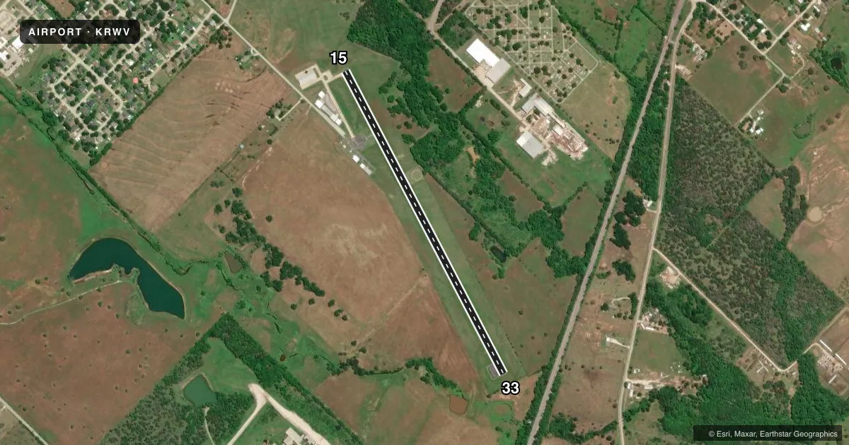
Airport sketch
Runways drawn to scale from FAA survey coordinates, rendered over satellite imagery. Not for navigation.
Approaches & charts
Services on the field
Fuel grades, oxygen, maintenance, ramp storage and lighting — as declared to the FAA by the airport operator.
Fuel & services
- Fuel
- 100LL
- Oxygen (bottled)
- Not available
- Oxygen (bulk)
- Not available
- Airframe repair
- Not available
- Power plant repair
- Not available
Ramp & ground
- Transient storage
- Tie-down
- Landing fee
- No fee published
- Customs
- Not available
- Lighting schedule
- SEE RMK
- Beacon schedule
- SS-SR
- Beacon
- White / Green (civil land)(WG)
- Wind indicator
- Lighted
- Segmented circle
- Yes
Fuel & FBOs
Cheapest 100LL and Jet A on the field and nearby. Always confirm with the FBO before taxi.
Airport notes
Surface conditions, obstructions, local procedures, lighting outages and other notes published with each FAA cycle.
General notes
- FOR CD CTC HOUSTON APCH AT 281-443-5844 TO CNL IFR CALL 281-443-5888.
- RWY 15, 17 FT BLDG. PENETRATES TRSN SFC, 104 FT FM RWY END, 260 FT R.
Lighting notes
- DUSK-DAWN, MIRL RWY 15/33 PRESET LOW INTST; TO INCR INTST AND ACTVT PAPI RWY 15 - CTAF.
Runway surface & condition
- 15/33PHOTOCELL SENSOR.
Approach & departure obstructions
- 1530 FT TREES, 131-201 FT DSTC, 189-250 FT L.
- 3320 FT TREES, 120 FT DSTC, 200 FT L.
- 15CTLG OBSTN EXCEEDS A 45 DEG SLOPE.
- 33APCH SLOPE 16:1 TO DSPLCD THR.
Other notes
- THIS AIRPORT HAS BEEN SURVEYED BY THE NATIONAL GEODETIC SURVEY.
- MANAGERCITY MANAGER.
- MANAGEREXT 102. MGR CELL 979-406-0465
VFR map & nearby airports
VFR sectional. Tap any ICAO chip to open that airport.
Key facts · KRWV
Answer card- ICAO
- KRWV
- Name
- CALDWELL MUNI
- Location
- CALDWELL, TEXAS
- Elevation
- 390.6 ft MSL
- Traffic pattern altitude
- 1,390.6 ft MSL (1,000 AGL)
- Control tower
- Non-towered (use CTAF)
- Total runways
- 1
- Longest runway
- 15/33 · 3,252 ft
- Published ILS approaches
- 0
- Published frequencies
- 3
- Magnetic variation
- 6°
- Current flight rules
- IFR
- Current wind
- 220° at 7 kt
- Favored runway now
- RWY 15
Caldwell Muni sits in Caldwell, Texas. Field elevation is 390.6 ft MSL. The airport has one runway. Runway 15/33 is 3,252 ft long and asphalt. There is no control tower. CTAF is 122.9. No ILS approaches are published here.
Pattern altitude is not published. Use the standard 1,000 ft AGL pattern unless the current Chart Supplement says otherwise. The airport is in the Houston approach area for IFR handling. Published remarks also call out several obstructions near both runway ends. There is a 17 ft building near the runway 15 side. Trees are also listed near runway 15 and runway 33. That makes a close look at departure and arrival paths a good idea, especially if you are coming in low or heavy.
On the field, Aviators Plus is the listed FBO. It carries 100LL. Runway lighting is controlled by a photocell sensor. From dusk to dawn, the lights are preset to low intensity. Use CTAF to increase intensity and to activate the PAPI for runway 15. For IFR work, Houston Approach handles clearance delivery and IFR cancellation by phone per the published remarks. If you are new to the field, plan for a small non-towered airport with a single short runway and nearby obstructions. Check the current Chart Supplement before you go.