METAR & TAF 11R
Current METAR
Observed 06:55Z
K11R 270655Z AUTO 19004KT 10SM CLR 26/23 A2998 RMK AO2 T02560233
- Wind
- 190° @ 4 kt
- Visibility
- 10 SM
- Temp / Dew
- 26°C / 23°C
- Altimeter
- 29.98 inHg
- Clouds
- CLR
- Density alt
- 1,640 ft
- Ceiling
- Unlimited
- Rules
- VFR
Airport info & contacts
Manager on record, flight service, ARTCC, attendance schedule and pattern altitude — published by the FAA and refreshed every 28 days.
Location
- From city
- 3 NM NE
- VFR sectional
- HOUSTON
- ARTCC
- ZHU · HOUSTON
- NOTAM facility
- 11R (NOTAM-D)
Airport manager
- Name
- MEGAN MAINER
- Phone
- 979-337-7232
- Address
- 3001 AVIATION WAY, BRENHAM TX 77833
Flight service · Hours
- FSS CXO
- MONTGOMERY COUNTY1-800-WX-BRIEF
- Attendance
- MON - FRI · 0800-1700
Frequencies
Tap any row to copy the frequency to your clipboard.
Runways & pattern
Full pagePattern entry · RWY 16
LEFT TRAFFICRunway end performance
| End | TORA | TODA | ASDA | LDA | VGSI | Approach lights | Obstruction |
|---|---|---|---|---|---|---|---|
| 16 | — | — | — | — | PAPI 2-box left(3°) | — | 35', tree, 800' from thr, 225' R of cntrln, slope 17 |
| 34 | — | — | — | — | PAPI 4-box left(3.5°) | — | 37', trees, 760' from thr, 220' R of cntrln, slope 15 |
Declared distances in feet. TORA = takeoff run available, TODA = takeoff distance, ASDA = accelerate-stop, LDA = landing distance.
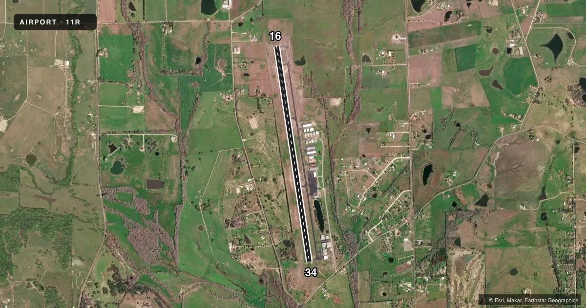
Airport sketch
Runways drawn to scale from FAA survey coordinates, rendered over satellite imagery. Not for navigation.
Approaches & charts
Services on the field
Fuel grades, oxygen, maintenance, ramp storage and lighting — as declared to the FAA by the airport operator.
Fuel & services
- Fuel
- 100LLA+
- Oxygen (bottled)
- Low pressure
- Airframe repair
- Major
- Power plant repair
- Major
- Other services
- CHTR
Ramp & ground
- Transient storage
- Tie-down
- Landing fee
- No fee published
- Customs
- Not available
- Lighting schedule
- SEE RMK
- Beacon schedule
- SS-SR
- Beacon
- White / Green (civil land)(WG)
- Wind indicator
- Lighted
- Segmented circle
- Yes
Fuel & FBOs
Cheapest 100LL and Jet A on the field and nearby. Always confirm with the FBO before taxi.
Airport notes
Surface conditions, obstructions, local procedures, lighting outages and other notes published with each FAA cycle.
General notes
- FOR CD CTC HOUSTON APCH AT 281-443-5844 TO CNL IFR CALL 281-443-5888.
- 94 FT LGTD RADAR ANT, 1060 FT WEST OF RWY 16 END.
Lighting notes
- MIRL RWY 16/34 PRESET MED SS-SR. TO ACTVT & INCR INTST - CTAF.
Fuel notes
- 100LLFUEL 24 HR SELF-SERV. FULL SVC AVBL DURG ATNDD HRS. FOR AFT HRS SVC 979-337-7245, CALL-IN FEE.
VFR map & nearby airports
VFR sectional. Tap any ICAO chip to open that airport.
Key facts · 11R
Answer card- ICAO
- 11R
- Name
- BRENHAM MUNI
- Location
- BRENHAM, TEXAS
- Elevation
- 317.7 ft MSL
- Traffic pattern altitude
- 1,317.7 ft MSL (1,000 AGL)
- Control tower
- Non-towered (use CTAF)
- Total runways
- 1
- Longest runway
- 16/34 · 6,003 ft
- Published ILS approaches
- 0
- Published frequencies
- 4
- Magnetic variation
- 6°
- Current flight rules
- VFR
- Current wind
- 190° at 4 kt
- Favored runway now
- RWY 16
Brenham Muni sits in Brenham, Texas. The field elevation is 317.7 ft MSL. It has one asphalt runway, 16/34, which is 6,003 ft long. That is the longest runway on the field. The airport is non-towered. Pattern altitude is not published, so use the standard 1,000 ft AGL for light piston traffic unless the current Chart Supplement or local procedures say otherwise.
No ILS approaches are published here. The airport uses CTAF 123.075 and UNICOM 123.075. Houston Approach handles IFR services on 134.3 and 360.85. The published remarks also note a 94-foot lighted radar antenna about 1,060 ft west of the runway 16 end. That is worth keeping in mind on departure and arrival, especially if you are working close to the runway environment.
Two on-field FBOs are listed. Brenham Aviation carries 100LL and Jet A. Aviators Plus carries 100LL and Jet A. Published remarks say 100LL is available 24 hours self-serve. Full-service fuel is available during attended hours. After-hours fuel is available by phone, with a call-in fee. Runway edge lights on 16/34 are preset from sunset to sunrise. Use the CTAF to turn them on or raise intensity. For IFR arrivals or departures, contact Houston Approach for clearance delivery and IFR cancellation details.