METAR & TAF KTME
Current METAR
Observed 08:35Z
KTME 270835Z AUTO 00000KT 10SM 25/25 A3000 RMK AO2
- Wind
- 000° @ 0 kt
- Visibility
- 10 SM
- Temp / Dew
- 25°C / 25°C
- Altimeter
- 30.00 inHg
- Clouds
- Clear
- Density alt
- 1,307 ft
- Ceiling
- Unlimited
- Rules
- VFR
Airport info & contacts
Manager on record, flight service, ARTCC, attendance schedule and pattern altitude — published by the FAA and refreshed every 28 days.
Location
- From city
- 28 NM W
- VFR sectional
- HOUSTON
- ARTCC
- ZHU · HOUSTON
- NOTAM facility
- CXO (NOTAM-D)
Airport manager
- Name
- ANDREW PERRY
- Phone
- 281-945-5000
- Address
- 1900 CARDIFF ROAD, BROOKSHIRE TX 77423
Flight service · Hours
- FSS CXO
- MONTGOMERY COUNTY1-800-WX-BRIEF
- Attendance
- ALL
Frequencies
Tap any row to copy the frequency to your clipboard.
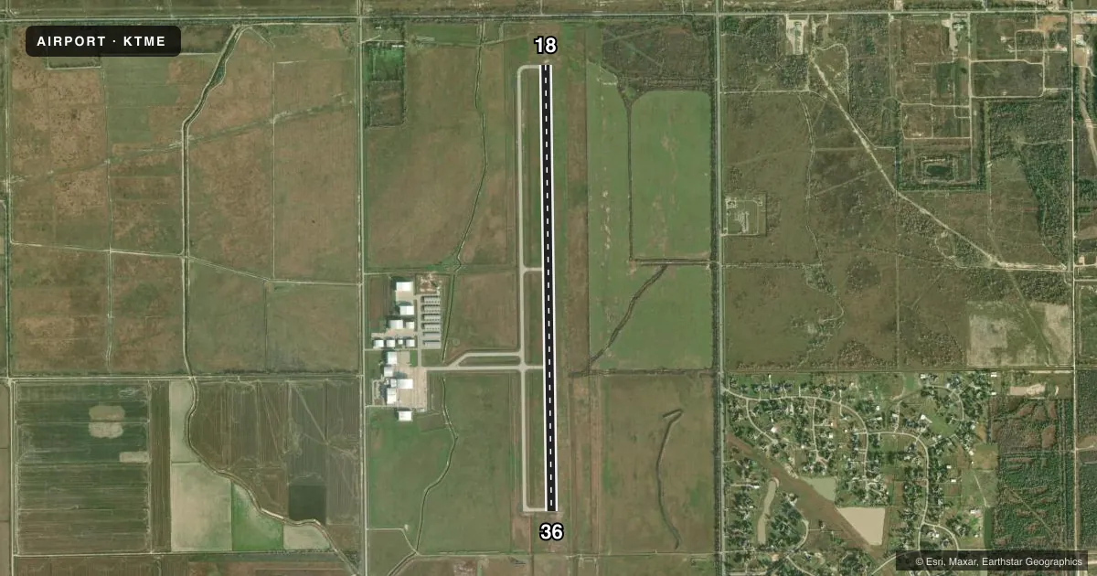
Runways & pattern
Full pagePattern entry · RWY 18
LEFT TRAFFICRunway end performance
| End | TORA | TODA | ASDA | LDA | VGSI | Approach lights | Obstruction |
|---|---|---|---|---|---|---|---|
| 18 | — | — | — | — | PAPI 4-box left(3°) | — | 17', pline, 765' from thr, 620' R of cntrln, slope 33 |
| 36 | — | — | — | — | PAPI 4-box left(3°) | — | — |
Declared distances in feet. TORA = takeoff run available, TODA = takeoff distance, ASDA = accelerate-stop, LDA = landing distance.
Airport sketch
Runways drawn to scale from FAA survey coordinates, rendered over satellite imagery. Not for navigation.
Approaches & charts
Services on the field
Fuel grades, oxygen, maintenance, ramp storage and lighting — as declared to the FAA by the airport operator.
Fuel & services
- Fuel
- 100LLA+
- Oxygen (bottled)
- HIGH/LOW
- Airframe repair
- Major
- Power plant repair
- Major
- Other services
- AFRT,AMB,CARGO,CHTR,INSTR
Ramp & ground
- Transient storage
- Tie-down
- Hangar
- Landing fee
- No fee published
- Lighting schedule
- SEE RMK
- Beacon schedule
- SS-SR
- Beacon
- White / Green (civil land)(WG)
- Wind indicator
- Lighted
- Segmented circle
- Yes
Fuel & FBOs
Cheapest 100LL and Jet A on the field and nearby. Always confirm with the FBO before taxi.
Airport notes
Surface conditions, obstructions, local procedures, lighting outages and other notes published with each FAA cycle.
General notes
- NOISE SENSITIVE AREA EAST OF ARPT IN EFFECT: AVOID HOUSING AREA.
- BIRDS ON & INVOF ARPT.
- FOR CD WHEN ATCT IS CLSD CTC HOUSTON APCH AT 281-443-5844 TO CNL IFR AT 281-443-5888.
Lighting notes
- ACTVT REIL RWYS 18 & 36; MIRL RWY 18/36 - CTAF.
Other notes
- PRVDD TFC PATTERN RESTRICTED TO EAST SIDE OF ARPT; TFC PATTERN ALTITUDE AT LEAST 800 FT AGL; AND A WILDLIFE HAZARD MGMT PLAN IS DEVELOPED AND IMPLEMENTED.
VFR map & nearby airports
VFR sectional. Tap any ICAO chip to open that airport.
Key facts · KTME
Answer card- ICAO
- KTME
- Name
- HOUSTON EXEC
- Location
- HOUSTON, TEXAS
- Elevation
- 165.9 ft MSL
- Traffic pattern altitude
- 1,165.9 ft MSL (1,000 AGL)
- Control tower
- Towered · 0700-2100
- Total runways
- 1
- Longest runway
- 18/36 · 6,610 ft
- Published ILS approaches
- 0
- Published frequencies
- 8
- Magnetic variation
- 4°
- Current flight rules
- VFR
- Current wind
- 000° at 0 kt
- Favored runway now
- –
Houston Executive Airport sits in Houston, Texas. Field elevation is 165.9 ft MSL. The airport has one runway, 18/36, which is 6,610 ft long. The tower is open daily from 0700 to 2100. No ILS approaches are published here, so plan your IFR work with that in mind. Check the current FAA Chart Supplement for approach details before you go.
The published pattern altitude is not standard in the data block. The Chart Supplement notes traffic pattern work is restricted to the east side of the airport. It also says pattern altitude is at least 800 ft AGL. That is the number to brief for this field. The airport has a noise sensitive area east of the airport. Avoid the housing area on that side. Birds are also reported on and near the airport. Keep a sharp lookout on arrival and departure.
Henriksen Jet Center is on the field. It carries 100LL, Jet A and Jet A Prist. Runway end identifier lights are active on 18 and 36. Medium intensity runway lights are on 18/36 and are controlled by CTAF. If you are arriving after tower hours, Houston Approach handles clearance delivery. Verify the current procedures with the airport operator or the FBO directly by phone before departure.