METAR & TAF T54
T54 does not publish a METAR.
Showing the nearest reporting station: KSGR (SUGAR LAND RGNL) · 8.8 NM away. Conditions at T54 may differ.
METAR · KSGR
Observed 06:53Z
KSGR 270653Z AUTO 21003KT 10SM FEW013 26/24 A2998 RMK AO2 SLP153 T02560244 $
- Wind
- 210° @ 3 kt
- Visibility
- 10 SM
- Temp / Dew
- 26°C / 24°C
- Altimeter
- 29.98 inHg
- Clouds
- FEW
- Density alt
- 1,362 ft
- Ceiling
- Unlimited
- Rules
- VFR
Airport info & contacts
Manager on record, flight service, ARTCC, attendance schedule and pattern altitude — published by the FAA and refreshed every 28 days.
Location
- From city
- 3 NM SE
- VFR sectional
- HOUSTON
- ARTCC
- ZHU · HOUSTON
- NOTAM facility
- CXO (NOTAM-D)
Airport manager
- Name
- LOGAN LANE
- Phone
- 281-342-5451
- Address
- PO BOX 432, ROSENBERG TX 77471
Flight service · Hours
- FSS CXO
- MONTGOMERY COUNTY1-800-WX-BRIEF
- Attendance
- MON-FRI · 0800-1600
Frequencies
Tap any row to copy the frequency to your clipboard.
Runways & pattern
Full pagePattern entry · RWY 13
LEFT TRAFFICRunway end performance
| End | TORA | TODA | ASDA | LDA | VGSI | Approach lights | Obstruction |
|---|---|---|---|---|---|---|---|
| 13 | — | — | — | — | — | — | 23', hangar, 201' from thr, 135' R of cntrln, slope 0 |
| 31 | — | — | — | — | — | — | 20', tree, 201' from thr, 230' R of cntrln, slope 0 |
Declared distances in feet. TORA = takeoff run available, TODA = takeoff distance, ASDA = accelerate-stop, LDA = landing distance.
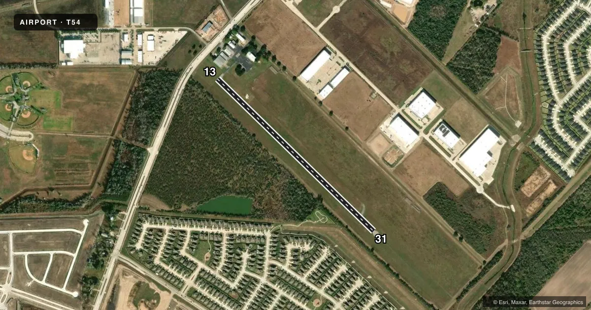
Airport sketch
Runways drawn to scale from FAA survey coordinates, rendered over satellite imagery. Not for navigation.
Approaches & charts
Services on the field
Fuel grades, oxygen, maintenance, ramp storage and lighting — as declared to the FAA by the airport operator.
Fuel & services
- Fuel
- 100LLA+
- Airframe repair
- Minor
- Power plant repair
- Minor
- Other services
- AGRI
Ramp & ground
- Transient storage
- Not published
- Landing fee
- No fee published
- Customs
- Not available
- Wind indicator
- Yes
- Segmented circle
- No
Fuel & FBOs
Cheapest 100LL and Jet A on the field and nearby. Always confirm with the FBO before taxi.
Airport notes
Surface conditions, obstructions, local procedures, lighting outages and other notes published with each FAA cycle.
General notes
- FOR CD CTC HOUSTON APCH AT 281-443-5844 TO CNL IFR CALL 281-443-5888.
- AGRICULTURAL AERIAL APPLICATION OPN.
Fuel notes
- 100LLFUEL AVBL MON-FRI 0800-1600.
Approach & departure obstructions
- 1323 FT HGR, 93 FT DSTC, 129-250 L.
- 3150 FT TREE, 80 FT DSTC, 230 FT L.
- 133 FT WHITE LINE 130 FT FM RWY END.
- 13CONTROLLING OBSTRUCTION EXCEEDS A 45 DEGREE SLOPE
- 13ALSO 50 FT PLINE, 428 FT DSTC, 160 FT L.
Other notes
- 1ACES GATES LOCKED NGTS & WKENDS.
- OWNERPHYSICAL ADDRESS: 3205 FM 2218, ROSENBERG, TX 77471
- MANAGERLOGAN@LANEAV.COM
VFR map & nearby airports
VFR sectional. Tap any ICAO chip to open that airport.
Key facts · T54
Answer card- ICAO
- T54
- Name
- LANE AIRPARK
- Location
- ROSENBERG, TEXAS
- Elevation
- 94.1 ft MSL
- Traffic pattern altitude
- 1,094.1 ft MSL (1,000 AGL)
- Control tower
- Non-towered (use CTAF)
- Total runways
- 1
- Longest runway
- 13/31 · 3,013 ft
- Published ILS approaches
- 0
- Published frequencies
- 1
- Magnetic variation
- 2°
- Current flight rules
- VFR
- Current wind
- 210° at 3 kt
- Favored runway now
- RWY 13
Lane Airpark sits in Rosenberg, Texas. The field elevation is 94.1 ft MSL. It has one runway, 13/31, which is 3,013 ft long and asphalt. This is a non-towered field, so plan to self-announce on CTAF 122.9 and keep your scan tight in the pattern.
No ILS approaches are published here. The pattern altitude is not published in the facts, so use the current FAA Chart Supplement for the published pattern. If no special pattern is published, plan on the standard 1,000 ft AGL for light piston operations. With the runway length and low field elevation, the airport works well for light aircraft. Still, check performance if you are heavy or if the summer heat is up. Houston Approach handles IFR clearance delivery here. The published remarks also note that agricultural aerial application is open.
Lane Aviation is on the field. It carries 100LL and Jet A. Fuel is published as available Monday through Friday from 0800 to 1700. Access gates are locked at night and on weekends, so plan ground transport and arrival timing with that in mind. If you need current operating details before departure, call the airport operator or the FBO directly by phone.