METAR & TAF X09
X09 does not publish a METAR.
Showing the nearest reporting station: KTME (HOUSTON EXEC) · 7.5 NM away. Conditions at X09 may differ.
METAR · KTME
Observed 06:15Z
KTME 270615Z AUTO 20004KT 10SM CLR 26/25 A3001 RMK AO2
- Wind
- 200° @ 4 kt
- Visibility
- 10 SM
- Temp / Dew
- 26°C / 25°C
- Altimeter
- 30.01 inHg
- Clouds
- CLR
- Density alt
- 1,370 ft
- Ceiling
- Unlimited
- Rules
- VFR
Airport info & contacts
Manager on record, flight service, ARTCC, attendance schedule and pattern altitude — published by the FAA and refreshed every 28 days.
Location
- From city
- 3 NM E
- VFR sectional
- HOUSTON
- ARTCC
- ZHU · HOUSTON
- NOTAM facility
- CXO (NOTAM-D)
Airport manager
- Name
- GRANVILLE LASSETER II
- Phone
- 281-685-7540
- Address
- 10 WEST KITTY HAWK, RICHMOND TX 77406
Flight service · Hours
- FSS CXO
- MONTGOMERY COUNTY1-800-WX-BRIEF
- Attendance
- Unattended
Frequencies
Tap any row to copy the frequency to your clipboard.
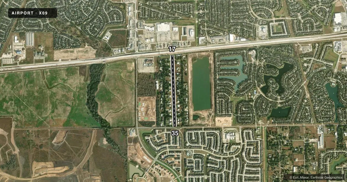
Runways & pattern
Full pagePattern entry · RWY 17
LEFT TRAFFICRunway end performance
| End | TORA | TODA | ASDA | LDA | VGSI | Approach lights | Obstruction |
|---|---|---|---|---|---|---|---|
| 17 | — | — | — | — | VASI 2-box left | — | 45', tree, 0' from thr, 100' R of cntrln, slope 0 |
| 35 | — | — | — | — | — | — | 33', tree, 0' from thr, 95' R of cntrln, slope 0 |
Declared distances in feet. TORA = takeoff run available, TODA = takeoff distance, ASDA = accelerate-stop, LDA = landing distance.
Airport sketch
Runways drawn to scale from FAA survey coordinates, rendered over satellite imagery. Not for navigation.
Approaches & charts
Services on the field
Fuel grades, oxygen, maintenance, ramp storage and lighting — as declared to the FAA by the airport operator.
Fuel & services
- Fuel
- Not available
Ramp & ground
- Transient storage
- Not published
- Landing fee
- Yes
- Lighting schedule
- SEE RMK
- Beacon schedule
- SEE RMK
- Beacon
- White / Green (civil land)(WG)
- Wind indicator
- Lighted
- Segmented circle
- No
Fuel & FBOs
Cheapest 100LL and Jet A on the field and nearby. Always confirm with the FBO before taxi.
Airport notes
Surface conditions, obstructions, local procedures, lighting outages and other notes published with each FAA cycle.
General notes
- BASE LEGS AND TURNS TO FINAL APCH MUST BE WITHIN .75 NM OF THE RWY ENDS.
- FOR CD CTC HOUSTON APCH AT 281-443-5844 TO CNL IFR CALL 281-443-5888.
- CELL TWR, 1.5 MILES SOUTH OF RWY 17 END.
- STUDENT TNG PROHIBITED.
Lighting notes
- RTG BCN DUSK-2200.
- DUSK-2200. ACTVT LIRL RWY 17/35 AFT 2200 - CTAF.
Runway surface & condition
- 17/35NSTD LIRL; 2800 FT OF RWY LGTD AT NIGHT BTN DSPLCD THLDS.
Approach & departure obstructions
- 17APCH SLOPE 7:1 TO DSPLCD THR OVR 33 FT TREE 115 FT FM DSPLCD THR 96 FT LEFT.
- 35APCH SLOPE 7:1 TO DSPLCD THR.
Other notes
- PRVDD ARPT TFC PAT MUST MAINTAIN BASE LEGS AND TURNS TO FINAL APCH WITHIN 0.75 NM OF THE RWY ENDS, AND THE SPECIAL SIAP WILL REMAIN UNTIL THE REIMBURSABLE AGREEMENT IS CANCELLED OR FTW FPO IS REQUESTED TO PUBLISH IT.
- MANAGERADD'L CONTACT LISA HAAG, 832-654-4224, MSPILOT2000@MAC.COM.
- OWNERCHRIS MALLORY, PRESIDENT, COVEY TRAILS CIVIC CLUB.
- 17/35SOFT AREAS, UNRETRACTED SPRINKLER HEADS ON RWY.
VFR map & nearby airports
VFR sectional. Tap any ICAO chip to open that airport.
Key facts · X09
Answer card- ICAO
- X09
- Name
- COVEY TRAILS
- Location
- FULSHEAR, TEXAS
- Elevation
- 130 ft MSL
- Traffic pattern altitude
- 1,130 ft MSL (1,000 AGL)
- Control tower
- Non-towered (use CTAF)
- Total runways
- 1
- Longest runway
- 17/35 · 3,352 ft
- Published ILS approaches
- 0
- Published frequencies
- 2
- Magnetic variation
- 6°
- Current flight rules
- VFR
- Current wind
- 200° at 4 kt
- Favored runway now
- RWY 17
Covey Trails is in Fulshear, Texas. Field elevation is 130 ft MSL. The airport has one runway. Runway 17/35 is 3,352 ft of turf. No tower is published here, so use CTAF 122.725 for traffic calls and monitor the field closely. No ILS approaches are published.
Pattern altitude is not published. Use the standard 1,000 ft AGL pattern unless the current FAA Chart Supplement says otherwise. That puts the pattern at about 1,130 ft MSL based on the field elevation. The published remarks matter here. Base legs and turns to final must stay within 0.75 NM of the runway ends. There are also tree obstructions near both ends. Runway 17 has a visual approach slope indicator that operates continuously. Lights run from dusk to 2200. After 2200, low intensity runway lights on 17/35 are activated on CTAF.
There are no on-field FBOs listed. Plan on self-sufficiency and verify services before you go. The field also has soft areas and unretracted sprinkler heads on the runway. That makes surface condition and braking worth checking before landing. Houston Approach handles IFR clearance delivery at the published phone numbers in the Chart Supplement. The airport sits in the Houston area, so expect local traffic and stay sharp on pattern discipline.