METAR & TAF T51
T51 does not publish a METAR.
Showing the nearest reporting station: KDWH (DAVID WAYNE HOOKS MEML) · 6.1 NM away. Conditions at T51 may differ.
METAR · KDWH
Observed 04:53Z
KDWH 270453Z AUTO 20008KT 10SM CLR 28/23 A3000 RMK AO2 SLP155 T02780233 $
- Wind
- 200° @ 8 kt
- Visibility
- 10 SM
- Temp / Dew
- 28°C / 23°C
- Altimeter
- 30.00 inHg
- Clouds
- CLR
- Density alt
- 1,667 ft
- Ceiling
- Unlimited
- Rules
- VFR
Airport info & contacts
Manager on record, flight service, ARTCC, attendance schedule and pattern altitude — published by the FAA and refreshed every 28 days.
Location
- From city
- 22 NM NW
- VFR sectional
- HOUSTON
- ARTCC
- ZHU · HOUSTON
- NOTAM facility
- CXO (NOTAM-D)
Airport manager
- Name
- DANIEL JONES
- Phone
- 936-521-9887
- Address
- 16434 KITZMAN, CYPRESS TX 77429
Flight service · Hours
- FSS CXO
- MONTGOMERY COUNTY1-800-WX-BRIEF
- Attendance
- DAWN-0000
Frequencies
Tap any row to copy the frequency to your clipboard.
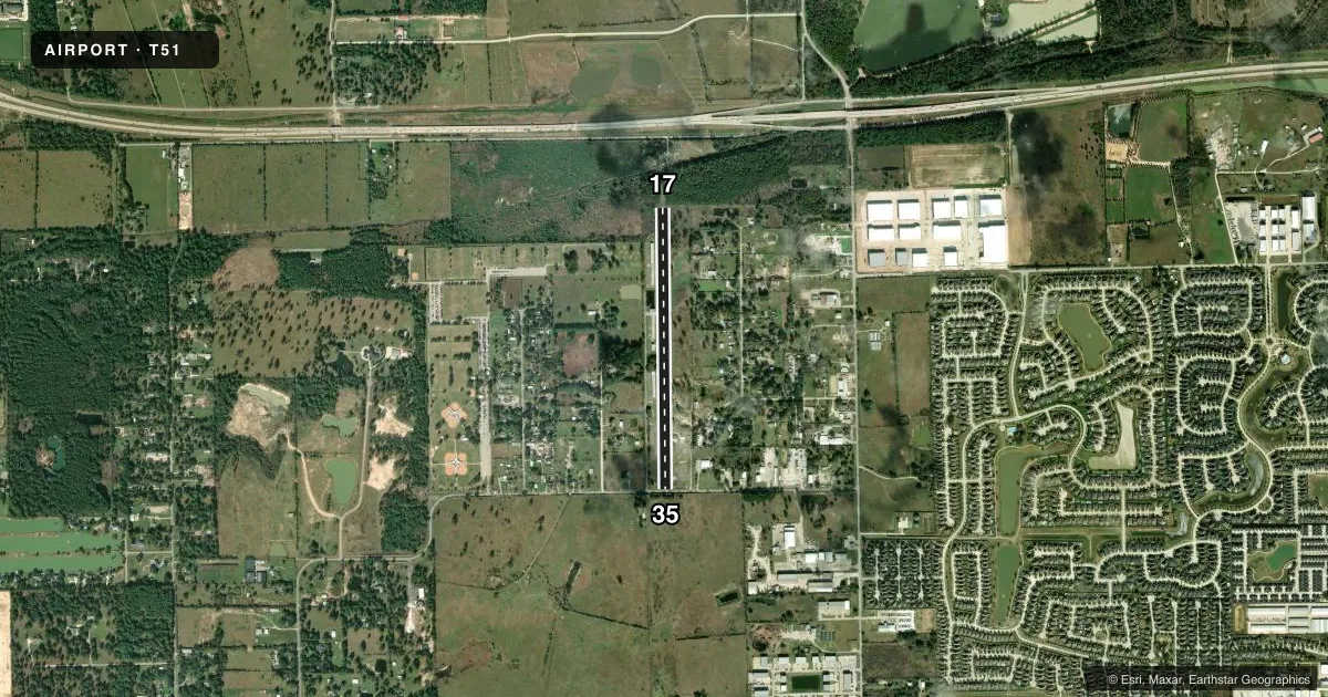
Runways & pattern
Full pagePattern entry · RWY 17
LEFT TRAFFICRunway end performance
| End | TORA | TODA | ASDA | LDA | VGSI | Approach lights | Obstruction |
|---|---|---|---|---|---|---|---|
| 17 | — | — | — | — | — | — | 35', trees, 201' from thr, 125' R of cntrln, slope 0 |
| 35 | — | — | — | — | — | — | 21', pline, 10' from thr, 0' R of cntrln, slope 0 |
Declared distances in feet. TORA = takeoff run available, TODA = takeoff distance, ASDA = accelerate-stop, LDA = landing distance.
Airport sketch
Runways drawn to scale from FAA survey coordinates, rendered over satellite imagery. Not for navigation.
Approaches & charts
Services on the field
Fuel grades, oxygen, maintenance, ramp storage and lighting — as declared to the FAA by the airport operator.
Fuel & services
- Fuel
- 100LL
- Airframe repair
- Major
- Power plant repair
- Major
- Other services
- AMB
Ramp & ground
- Transient storage
- Tie-down
- Landing fee
- Yes
- Lighting schedule
- SEE RMK
- Beacon schedule
- SEE RMK
- Beacon
- White / Green (civil land)(WG)
- Wind indicator
- Yes
- Segmented circle
- No
Fuel & FBOs
Cheapest 100LL and Jet A on the field and nearby. Always confirm with the FBO before taxi.
Airport notes
Surface conditions, obstructions, local procedures, lighting outages and other notes published with each FAA cycle.
General notes
- RWY 17/35 4 FT FENCE 53 FT EAST OF CNTRLN.
- DEER ON RWYS.
- NORTH-SOUTH TRANSITIONAL ACFT WEST OF FIELD.
- LEFT HAND TFC 500 FT & 1000 FT MSL.
- CATTLE INVOF RWY.
- ARPT CLSD MIDNIGHT TO DAWN.
- PPR FOR ROTOR WING ACFT.
- FOR CD CTC HOUSTON APCH AT 281-443-5844 TO CNL IFR CALL 281-443-5888.
Lighting notes
- FOR ROTG BCN CALL 936-521-9887.
- SS-SR, ACTVT LIRL RWY 17/35- CTAF.
Runway surface & condition
- 17/35RWY 17/35 2365 FT X 30 FT ASPH ON N END.
- 17/35RWY 17/35 NSTD LIRL; NSTD COLORS, SINGLE THR LGT EACH RWY END. 2240 FT OF RWY USBL FOR NGT OPNS. RWY 17 THR RELCTD 300 FT FOR NGT OPNS; RWY 35 THR RELCTD 900 FT FOR NGT OPNS.
Approach & departure obstructions
- 1750 FT TREES, 0-199 DSTC, 125 FT L/R.
- 17THR DSPLCD 255 FT DAYS ONLY.
- 35THR DSPLCD 400 FT DAYS ONLY.
- 35SOUTH 1000 FT OF RWY TURF, NO MKGS.
- 17THR BAR 2 FT WIDE.
- 17APCH RATIO 0:1 AT DSPLCD THR, 50 FT TREES 100 FT L.
- 35APCH RATIO 0:1 AT DAY DSPLCD THR; +4 FT FENCES 53 FT R.
Other notes
- THIS AIRPORT HAS BEEN SURVEYED BY THE NATIONAL GEODETIC SURVEY.
- PRVDD RWY 36 THR LCTD AT OR DSPLCD TO A POINT LCTD FAR ENOUGH FROM PLINE TO PRVD 20:1 APCH.
- MANAGER936-494-8909 ASST. MGR.
- 17/35NORTH END 2365 FT X 30 FT ASPH.
VFR map & nearby airports
VFR sectional. Tap any ICAO chip to open that airport.
Key facts · T51
Answer card- ICAO
- T51
- Name
- DAN JONES INTL
- Location
- HOUSTON, TEXAS
- Elevation
- 166 ft MSL
- Traffic pattern altitude
- 1,166 ft MSL (1,000 AGL)
- Control tower
- Non-towered (use CTAF)
- Total runways
- 1
- Longest runway
- 17/35 · 3,440 ft
- Published ILS approaches
- 0
- Published frequencies
- 2
- Magnetic variation
- 5°
- Current flight rules
- VFR
- Current wind
- 200° at 8 kt
- Favored runway now
- RWY 17
Dan Jones Intl (T51) sits in Houston, Texas at 166 ft MSL. It has one runway, 17/35, which is 3,440 ft long and surfaced with asphalt-turf. The field is non-towered. CTAF and UNICOM are both 122.8. No ILS approaches are published here.
The pattern is left-hand. Pattern altitude is 500 ft AGL, which is 1,000 ft MSL. That is the number to brief, not a standard 1,000 ft AGL guess. The runway lighting is low-intensity and is activated by CTAF from sunset to sunrise. The airport also has a displaced threshold on runway 17 during the day. The threshold is moved 255 ft in daytime use.
Dan Jones International Airport is the on-field FBO. Fuel grades are not reported in the facts, so verify current fuel options with the FBO directly before you go. The remarks also note deer on the runways, cattle near the runway and north-south transitional aircraft west of the field. Rotor wing aircraft need prior permission. For IFR clearance delivery, contact Houston Approach. If you need to cancel IFR, use the published Houston Approach number. If you are planning a first visit, brief the displaced threshold, the animal hazard and the mixed surface runway before departure.