METAR & TAF 60R
Current METAR
Observed 05:55Z
K60R 270555Z AUTO 18007KT 10SM CLR 26/25 A2998 RMK AO2 SLP071 60000 T02590254 10332 20259 403480219 51009 $
- Wind
- 180° @ 7 kt
- Visibility
- 10 SM
- Temp / Dew
- 26°C / 25°C
- Altimeter
- 29.98 inHg
- Clouds
- CLR
- Density alt
- 1,530 ft
- Ceiling
- Unlimited
- Rules
- VFR
Airport info & contacts
Manager on record, flight service, ARTCC, attendance schedule and pattern altitude — published by the FAA and refreshed every 28 days.
Location
- From city
- 2 NM SW
- VFR sectional
- HOUSTON
- ARTCC
- ZHU · HOUSTON
- NOTAM facility
- CXO (NOTAM-D)
Airport manager
- Name
- JENNIFER REYNA
- Phone
- 936-825-6450
- Address
- PO BOX 910, NAVASOTA TX 77868
Flight service · Hours
- FSS CXO
- MONTGOMERY COUNTY1-800-WX-BRIEF
- Attendance
- Unattended
Frequencies
Tap any row to copy the frequency to your clipboard.
Runways & pattern
Full pagePattern entry · RWY 17
LEFT TRAFFICRunway end performance
| End | TORA | TODA | ASDA | LDA | VGSI | Approach lights | Obstruction |
|---|---|---|---|---|---|---|---|
| 17 | — | — | — | — | PAPI 2-box left(3°) | — | 35', tree, 930' from thr, 263' R of cntrln, slope 20 |
| 35 | — | — | — | — | PAPI 2-box left(3°) | — | 95', trees, 2100' from thr, 535' R of cntrln, slope 20 |
Declared distances in feet. TORA = takeoff run available, TODA = takeoff distance, ASDA = accelerate-stop, LDA = landing distance.
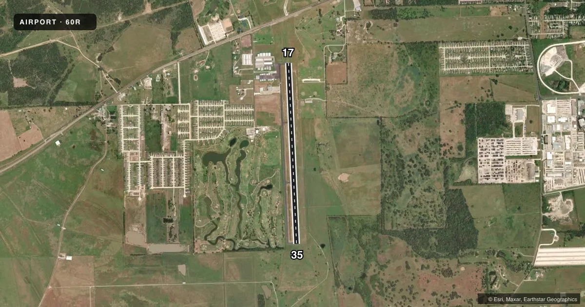
Airport sketch
Runways drawn to scale from FAA survey coordinates, rendered over satellite imagery. Not for navigation.
Approaches & charts
Services on the field
Fuel grades, oxygen, maintenance, ramp storage and lighting — as declared to the FAA by the airport operator.
Fuel & services
- Fuel
- 100LLA
- Oxygen (bottled)
- Not available
- Oxygen (bulk)
- Not available
- Airframe repair
- Major
- Power plant repair
- Major
Ramp & ground
- Transient storage
- Tie-down
- Landing fee
- No fee published
- Customs
- Not available
- Lighting schedule
- SEE RMK
- Beacon schedule
- SS-SR
- Beacon
- White / Green (civil land)(WG)
- Wind indicator
- Lighted
- Segmented circle
- Yes
Fuel & FBOs
Cheapest 100LL and Jet A on the field and nearby. Always confirm with the FBO before taxi.
Airport notes
Surface conditions, obstructions, local procedures, lighting outages and other notes published with each FAA cycle.
General notes
- 16 FT MKD PWR LINE RWY 17, 1300 FT DSTC; 50 FT PWR LINE, 2500 FT DSTC.
- FOR CD CTC HOUSTON APCH AT 281-443-5844 TO CNL IFR CALL 281-443-5888.
Lighting notes
- ACTVT PAPI RWY 17 & 35; MIRL RWY 17/35 - 123.3
Other notes
- PRE DATES THE ACT.
VFR map & nearby airports
VFR sectional. Tap any ICAO chip to open that airport.
Key facts · 60R
Answer card- ICAO
- 60R
- Name
- NAVASOTA MUNI
- Location
- NAVASOTA, TEXAS
- Elevation
- 229 ft MSL
- Traffic pattern altitude
- 1,229 ft MSL (1,000 AGL)
- Control tower
- Non-towered (use CTAF)
- Total runways
- 1
- Longest runway
- 17/35 · 5,003 ft
- Published ILS approaches
- 0
- Published frequencies
- 3
- Magnetic variation
- 3°
- Current flight rules
- VFR
- Current wind
- 180° at 7 kt
- Favored runway now
- RWY 17
Navasota Muni sits in Navasota, Texas at 229 ft MSL. It has one runway, 17/35 and the longest runway is 5,003 ft of asphalt. There is no control tower. Pattern altitude is not published, so use the standard 1,000 ft AGL for light piston operations unless the current Chart Supplement says otherwise. No ILS approaches are published here.
Spinner Aviation is on the field. It carries 100LL and Jet A. Call (979) 314-4771 before you go if you need current service details. For IFR work, Houston Approach handles clearance delivery and approach or departure services. The published remarks also note PAPI on runways 17 and 35. Medium intensity runway lights are available on both ends. There are marked power lines near runway 17. One is 16 ft and sits 1,300 ft from the threshold. Another is 50 ft and sits 2,500 ft out. That is worth keeping in mind on departure and arrival.
This is an uncontrolled field with published IFR support from Houston. Check the current Chart Supplement for any changes before flight. If you are planning a night arrival or a low-visibility approach, verify the lighting and IFR procedures with the airport operator or the FBO directly by phone.