METAR & TAF KUTS
Current METAR
Observed 10:53Z
KUTS 271053Z AUTO 21003KT 10SM CLR 24/23 A2999 RMK AO1 SLP150 T02440233
- Wind
- 210° @ 3 kt
- Visibility
- 10 SM
- Temp / Dew
- 24°C / 23°C
- Altimeter
- 29.99 inHg
- Clouds
- CLR
- Density alt
- 1,443 ft
- Ceiling
- Unlimited
- Rules
- VFR
Airport info & contacts
Manager on record, flight service, ARTCC, attendance schedule and pattern altitude — published by the FAA and refreshed every 28 days.
Location
- From city
- 2 NM NW
- VFR sectional
- HOUSTON
- ARTCC
- ZHU · HOUSTON
- NOTAM facility
- UTS (NOTAM-D)
Airport manager
- Name
- LAYNE YEAGER
- Phone
- 936-295-8136
- Address
- 1212 AVENUE M, HUNTSVILLE TX 77340
Flight service · Hours
- FSS CXO
- MONTGOMERY COUNTY1-800-WX-BRIEF
- Attendance
- DAWN-DUSK
Frequencies
Tap any row to copy the frequency to your clipboard.
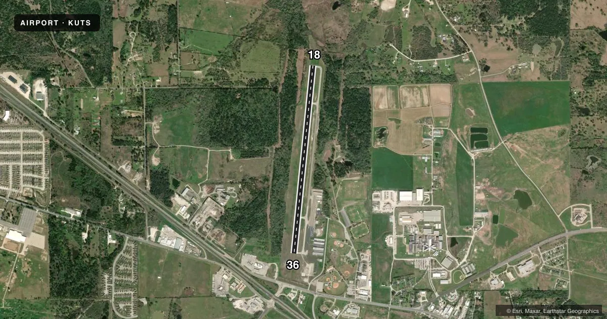
Runways & pattern
Full pagePattern entry · RWY 18
LEFT TRAFFICRunway end performance
| End | TORA | TODA | ASDA | LDA | VGSI | Approach lights | Obstruction |
|---|---|---|---|---|---|---|---|
| 18 | — | — | — | — | PAPI 4-box left(3°) | — | 30', trees, 201' from thr, 175' R of cntrln, slope 0 |
| 36 | — | — | — | — | PAPI 4-box left(3°) | — | 45', pole, 1135' from thr, 195' R of cntrln, slope 20 |
Declared distances in feet. TORA = takeoff run available, TODA = takeoff distance, ASDA = accelerate-stop, LDA = landing distance.
Airport sketch
Runways drawn to scale from FAA survey coordinates, rendered over satellite imagery. Not for navigation.
Approaches & charts
Services on the field
Fuel grades, oxygen, maintenance, ramp storage and lighting — as declared to the FAA by the airport operator.
Fuel & services
- Fuel
- 100LLA+
- Oxygen (bottled)
- Not available
- Oxygen (bulk)
- High pressure
- Airframe repair
- Major
- Power plant repair
- Major
- Other services
- INSTR,RNTL
Ramp & ground
- Transient storage
- Tie-down
- Hangar
- Landing fee
- No fee published
- Customs
- Not available
- Lighting schedule
- SEE RMK
- Beacon schedule
- SS-SR
- Beacon
- White / Green (civil land)(WG)
- Wind indicator
- Lighted
- Segmented circle
- Yes
Fuel & FBOs
Cheapest 100LL and Jet A on the field and nearby. Always confirm with the FBO before taxi.
Airport notes
Surface conditions, obstructions, local procedures, lighting outages and other notes published with each FAA cycle.
General notes
- FOR CD IF UNA TO CTC ON FSS FREQ, CTC HOUSTON ARTCC AT 281-230-5622.
Lighting notes
- DUSK-DAWN. MIRL RWY 18/36 PRESET LOW INTST; TO INCR INTST & ACTVT REIL RWYS 18 & 36 - CTAF.
Approach & departure obstructions
- 1832 FT TREES 0-199 FT DSTC, 165FT RIGHT.
Other notes
- THIS AIRPORT HAS BEEN SURVEYED BY THE NATIONAL GEODETIC SURVEY.
- MANAGERCITY/AIRPORT MANAGER
- MANAGERFBO/ON SITE ATTENDANT, WADE GILASPIE.
VFR map & nearby airports
VFR sectional. Tap any ICAO chip to open that airport.
Key facts · KUTS
Answer card- ICAO
- KUTS
- Name
- HUNTSVILLE MUNI
- Location
- HUNTSVILLE, TEXAS
- Elevation
- 362.9 ft MSL
- Traffic pattern altitude
- 1,362.9 ft MSL (1,000 AGL)
- Control tower
- Non-towered (use CTAF)
- Total runways
- 1
- Longest runway
- 18/36 · 5,005 ft
- Published ILS approaches
- 0
- Published frequencies
- 2
- Magnetic variation
- 6°
- Current flight rules
- VFR
- Current wind
- 210° at 3 kt
- Favored runway now
- RWY 18
Huntsville Muni sits in Huntsville, Texas at 362.9 ft MSL. It has one runway, 18/36, which is 5,005 ft long and paved with asphalt. The field is non-towered. CTAF and UNICOM are both 122.8. No ILS approaches are published here.
The pattern altitude is not published. Use the standard 1,000 ft AGL for light piston traffic unless the current Chart Supplement says otherwise. That puts the pattern at about 1,363 ft MSL based on field elevation, but verify before you fly. Huntsville Aviation is on the field. It carries 100LL and Jet A. The on-site attendant is Wade Gilaspie.
A few operational items matter here. Runway 18/36 has medium intensity lights that default to low intensity from dusk to dawn. Use CTAF to raise the intensity and turn on the runway end identifier lights for runways 18 and 36. There are trees near the right side of runway 18. They sit close in, so plan your approach and rollout with that in mind. If you need clearance delivery and cannot raise flight service, contact Houston ARTCC at the number listed in the Chart Supplement. This is a good field to brief carefully before arrival, especially for night use or if you are new to the airport.