METAR & TAF 33R
33R does not publish a METAR.
Showing the nearest reporting station: KDKR (HOUSTON COUNTY) · 18.2 NM away. Conditions at 33R may differ.
METAR · KDKR
Observed 14:35Z
KDKR 101435Z AUTO 00000KT 29/25 A3006 RMK AO2
- Wind
- 000° @ 0 kt
- Visibility
- —
- Temp / Dew
- 29°C / 25°C
- Altimeter
- 30.06 inHg
- Clouds
- Clear
- Density alt
- 1,928 ft
- Ceiling
- Unlimited
- Rules
- VFR
Airport info & contacts
Manager on record, flight service, ARTCC, attendance schedule and pattern altitude — published by the FAA and refreshed every 28 days.
Location
- From city
- 3 NM NW
- VFR sectional
- HOUSTON
- ARTCC
- ZHU · HOUSTON
- NOTAM facility
- CXO (NOTAM-D)
Airport manager
- Name
- JUDGE DANNY MARTIN
- Phone
- 936-642-1746
- Address
- TRINITY COUNTY COURTHOUSE, 162 WEST FIRST STREET, GROVETON TX 75845
Flight service · Hours
- FSS CXO
- MONTGOMERY COUNTY1-800-WX-BRIEF
- Attendance
- Unattended
Frequencies
Tap any row to copy the frequency to your clipboard.
Runways & pattern
Full pagePattern entry · RWY 16
LEFT TRAFFICRunway end performance
| End | TORA | TODA | ASDA | LDA | VGSI | Approach lights | Obstruction |
|---|---|---|---|---|---|---|---|
| 16 | — | — | — | — | — | — | 100', trees, 2260' from thr, 330' R of cntrln, slope 20 |
| 34 | — | — | — | — | — | — | 75', trees, 1415' from thr, 270' R of cntrln, slope 16 |
Declared distances in feet. TORA = takeoff run available, TODA = takeoff distance, ASDA = accelerate-stop, LDA = landing distance.
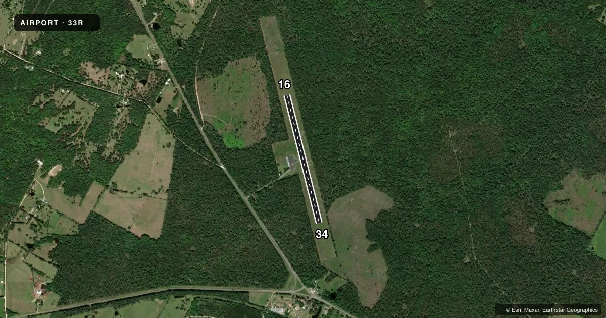
Airport sketch
Runways drawn to scale from FAA survey coordinates, rendered over satellite imagery. Not for navigation.
Approaches & charts
Services on the field
Fuel grades, oxygen, maintenance, ramp storage and lighting — as declared to the FAA by the airport operator.
Fuel & services
- Fuel
- Not available
- Oxygen (bottled)
- Not available
- Oxygen (bulk)
- Not available
- Airframe repair
- Not available
- Power plant repair
- Not available
Ramp & ground
- Transient storage
- Tie-down
- Landing fee
- No fee published
- Customs
- Not available
- Lighting schedule
- SEE RMK
- Beacon schedule
- SS-SR
- Beacon
- White / Green (civil land)(WG)
- Wind indicator
- Lighted
- Segmented circle
- Yes
Fuel & FBOs
Cheapest 100LL and Jet A on the field and nearby. Always confirm with the FBO before taxi.
Airport notes
Surface conditions, obstructions, local procedures, lighting outages and other notes published with each FAA cycle.
General notes
- DEER AND FERAL HOGS ON & INVOF ARPT.
- FOR CD CTC HOUSTON ARTCC AT 281-230-5622.
Lighting notes
- ACTVT LIRL RY 16/34 - CTAF.
Other notes
- OWNERCITY OF GROVETON, 115 W FRONT ST, GROVETON, TX, 936-642-1122.
- MANAGERFACILITIES MGR BECKY DAVIS 936-707-7164, FACILITIES@CO.TRINITY.TX.US.
VFR map & nearby airports
VFR sectional. Tap any ICAO chip to open that airport.
Key facts · 33R
Answer card- ICAO
- 33R
- Name
- GROVETON/TRINITY COUNTY
- Location
- GROVETON, TEXAS
- Elevation
- 340 ft MSL
- Traffic pattern altitude
- 1,340 ft MSL (1,000 AGL)
- Control tower
- Non-towered (use CTAF)
- Total runways
- 1
- Longest runway
- 16/34 · 3,500 ft
- Published ILS approaches
- 0
- Published frequencies
- 1
- Magnetic variation
- 6°
- Current flight rules
- VFR
- Current wind
- 000° at 0 kt
- Favored runway now
- –
Groveton/Trinity County Airport sits in Groveton, Texas. The field elevation is 340 ft MSL. It has one runway. Runway 16/34 is 3,500 ft of asphalt. There is no control tower. CTAF is 122.9.
No ILS approaches are published here. Pattern altitude is not published in the facts, so use the standard 1,000 ft AGL for light piston traffic unless the current Chart Supplement says otherwise. The runway lights on 16/34 are low intensity. They are activated through the CTAF. That is useful after dark if you are planning a night arrival.
There are no on-field FBOs listed in the facts. Contact the airport operator directly before arrival if you need fuel, parking, or ramp details. The published remarks also note deer and feral hogs on and near the airport. That is a real operational issue for taxi, takeoff and landing. Clearance delivery is handled through Houston ARTCC at the number in the Chart Supplement. First-time visitors should also verify any local traffic or lighting notes before they depart.