METAR & TAF KOCH
Current METAR
Observed 05:56Z
KOCH 270556Z AUTO 18004KT CLR 27/24 A3000 RMK AO2 SLP157 T02670239 10339 20244 403560228 50005 PWINO TSNO RVRNO $
- Wind
- 180° @ 4 kt
- Visibility
- —
- Temp / Dew
- 27°C / 24°C
- Altimeter
- 30.00 inHg
- Clouds
- CLR
- Density alt
- 1,766 ft
- Ceiling
- Unlimited
- Rules
- VFR
Airport info & contacts
Manager on record, flight service, ARTCC, attendance schedule and pattern altitude — published by the FAA and refreshed every 28 days.
Location
- From city
- 3 NM SW
- VFR sectional
- HOUSTON
- ARTCC
- ZHU · HOUSTON
- NOTAM facility
- OCH (NOTAM-D)
Airport manager
- Name
- COLIN SMITH
- Phone
- 936-560-9567
- Address
- 556 TERRY CRAWFORD, OFC, NACOGDOCHES TX 75964
Flight service · Hours
- FSS CXO
- MONTGOMERY COUNTY1-800-WX-BRIEF
- Attendance
- MON-FRI · 0800-1700
- SAT-SUN · 0800-1600
Frequencies
Tap any row to copy the frequency to your clipboard.
Runways & pattern
Full pagePattern entry · RWY 18
LEFT TRAFFICRunway end performance
| End | TORA | TODA | ASDA | LDA | VGSI | Approach lights | Obstruction |
|---|---|---|---|---|---|---|---|
| 18 | — | — | — | — | PAPI 2-box left(3°) | — | 60', trees, 201' from thr, 495' R of cntrln, slope 0 |
| 36 | — | — | — | — | PAPI 2-box left(3°) | MALSR | 115', trees, 2500' from thr, 490' R of cntrln, slope 20 |
Declared distances in feet. TORA = takeoff run available, TODA = takeoff distance, ASDA = accelerate-stop, LDA = landing distance.
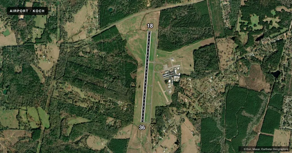
Airport sketch
Runways drawn to scale from FAA survey coordinates, rendered over satellite imagery. Not for navigation.
Approaches & charts
ILS · 1
Services on the field
Fuel grades, oxygen, maintenance, ramp storage and lighting — as declared to the FAA by the airport operator.
Fuel & services
- Fuel
- 100LLA+
- Oxygen (bottled)
- Not available
- Oxygen (bulk)
- Not available
- Airframe repair
- Major
- Power plant repair
- Major
- Other services
- INSTR,RNTL
Ramp & ground
- Transient storage
- Tie-down
- Landing fee
- No fee published
- Customs
- Not available
- Lighting schedule
- SEE RMK
- Beacon schedule
- SS-SR
- Beacon
- White / Green (civil land)(WG)
- Wind indicator
- Lighted
- Segmented circle
- Yes
Fuel & FBOs
Cheapest 100LL and Jet A on the field and nearby. Always confirm with the FBO before taxi.
Airport notes
Surface conditions, obstructions, local procedures, lighting outages and other notes published with each FAA cycle.
General notes
- 35 FT AGL AWOS ANT 400 FT WEST OF RWY 18/36 CNTRLN.
- BIRDS ON AND INVOF ARPT.
- FOR CD CTC HOUSTON ARTCC AT 281-230-5622.
- HIGH INTST STUDENT PILOT TRNG ON AND INVOF ARPT. MNT 122.75 FOR STUDENT AREAS OF ACTVTY.
Lighting notes
- DUSK-DAWN, MIRL RWY 18/36 PRESET LOW INTST. TO INCR INTST & ACTVT MALSR RWY 36; REIL RWY 18 - CTAF.
Fuel notes
- 100LL24 HR SELF SERVE 100LL & JET A+; ALSO AVBL FULL SVC DRG ATNDD HRS. FOR AFT HRS SVC CALL 936-560-9567. CALL-OUT FEE.
Runway surface & condition
- 18/36NO LINE OF SIGHT BTN RWY ENDS.
Approach & departure obstructions
- 18CONTROLLING OBSTRUCTION EXCEEDS A 45 DEGREE SLOPE
Other notes
- MANAGERARPT ATTENDANT/FBO/AMGR OFC 936-560-9567.
VFR map & nearby airports
VFR sectional. Tap any ICAO chip to open that airport.
Key facts · KOCH
Answer card- ICAO
- KOCH
- Name
- NACOGDOCHES A L MANGHAM JR RGNL
- Location
- NACOGDOCHES, TEXAS
- Elevation
- 343.2 ft MSL
- Traffic pattern altitude
- 1,343.2 ft MSL (1,000 AGL)
- Control tower
- Non-towered (use CTAF)
- Total runways
- 1
- Longest runway
- 18/36 · 5,001 ft
- Published ILS approaches
- 1
- Published frequencies
- 2
- Magnetic variation
- 1°
- Current flight rules
- VFR
- Current wind
- 180° at 4 kt
- Favored runway now
- RWY 18
Nacogdoches A L Mangham Jr Rgnl sits in Nacogdoches, Texas. Field elevation is 343.2 ft MSL. The airport has one runway. Runway 18/36 is 5,001 ft long with asphalt pavement. There is no control tower. CTAF and UNICOM are both 123.0. The field has one ILS approach to runway 36.
Pattern altitude is not published. Use 1,000 ft AGL for light piston traffic unless the current Chart Supplement says otherwise. The airport is in a training environment. Published remarks say high-intensity student pilot activity is on and in the vicinity of the airport. Monitor 122.75 for student areas of activity. Birds are also reported on and near the field.
On-field fuel and services are at A.L. Mangham Jr. Regional Airport. They carry 100LL and Jet A Prist. The remarks also say 24-hour self-serve 100LL and Jet A are available. Full service is available during attended hours. Call the airport at 936-560-9567 for after-hours service. A call-out fee applies. For clearance delivery, contact Houston ARTCC at 281-230-5622. Be ready for runway 18 obstruction notes. The controlling obstruction exceeds a 45 degree slope at runway 18. There is also no line of sight between runway ends.