METAR & TAF F17
Current METAR
Observed 13:15Z
KF17 271315Z AUTO 24004KT 10SM CLR 28/25 A3001 RMK AO2
- Wind
- 240° @ 4 kt
- Visibility
- 10 SM
- Temp / Dew
- 28°C / 25°C
- Altimeter
- 30.01 inHg
- Clouds
- CLR
- Density alt
- 1,844 ft
- Ceiling
- Unlimited
- Rules
- VFR
Airport info & contacts
Manager on record, flight service, ARTCC, attendance schedule and pattern altitude — published by the FAA and refreshed every 28 days.
Location
- From city
- 3 NM NE
- VFR sectional
- HOUSTON
- ARTCC
- ZFW · FORT WORTH
- NOTAM facility
- F17 (NOTAM-D)
Airport manager
- Name
- JOHN SOLICE
- Phone
- 936-598-8119
- Address
- 617 TENAHA ST, PO BOX 1744, CENTER TX 75935
Flight service · Hours
- FSS CXO
- MONTGOMERY COUNTY1-800-WX-BRIEF
- Attendance
- INTMNT
Frequencies
Tap any row to copy the frequency to your clipboard.
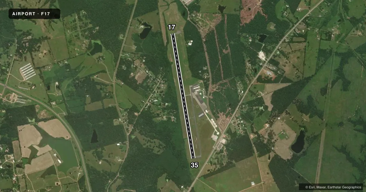
Runways & pattern
Full pagePattern entry · RWY 17
LEFT TRAFFICRunway end performance
| End | TORA | TODA | ASDA | LDA | VGSI | Approach lights | Obstruction |
|---|---|---|---|---|---|---|---|
| 17 | — | — | — | — | PAPI 2-box left(3°) | — | 26', trees, 201' from thr, 266' R of cntrln, slope 0 |
| 35 | — | — | — | — | PAPI 2-box left(3°) | — | 40', trees, 201' from thr, 355' R of cntrln, slope 0 |
Declared distances in feet. TORA = takeoff run available, TODA = takeoff distance, ASDA = accelerate-stop, LDA = landing distance.
Airport sketch
Runways drawn to scale from FAA survey coordinates, rendered over satellite imagery. Not for navigation.
Approaches & charts
Services on the field
Fuel grades, oxygen, maintenance, ramp storage and lighting — as declared to the FAA by the airport operator.
Fuel & services
- Fuel
- 100LLA+
- Oxygen (bottled)
- Not available
- Oxygen (bulk)
- Not available
- Airframe repair
- Minor
- Power plant repair
- Major
Ramp & ground
- Transient storage
- Tie-down
- Landing fee
- No fee published
- Customs
- Not available
- Lighting schedule
- SEE RMK
- Beacon schedule
- SS-SR
- Beacon
- White / Green (civil land)(WG)
- Wind indicator
- Lighted
- Segmented circle
- Yes
Fuel & FBOs
Cheapest 100LL and Jet A on the field and nearby. Always confirm with the FBO before taxi.
Airport notes
Surface conditions, obstructions, local procedures, lighting outages and other notes published with each FAA cycle.
General notes
- DEER ON & INVOF ARPT.
- FOR CD IF UNA TO CTC ON FSS FREQ, CTC FORT WORTH ARTCC AT 817-858-7584.
Lighting notes
- MIRL RWY 17/35 PRESET LOW INTST; TO INCR INTST ACTVT - CTAF.
Fuel notes
- 100LLSELF SVC FUEL.
Approach & departure obstructions
- 1740 FT TREES, 0-199 FT DSTC, 200 FT R.
- 3540 FT TREES, 199 FT DSTC, 244 FT R.
- 17CONTROLLING OBSTRUCTION EXCEEDS A 45 DEGREE SLOPE.
Other notes
- 1ON CALL 936-229-8105
- MANAGERARPT PHYS ADS 397 FM 1656.
- MANAGERJSOLICE@CENTERTEXAS.ORG, WAREHOUSE@CENTERTEXAS.ORG
VFR map & nearby airports
VFR sectional. Tap any ICAO chip to open that airport.
Key facts · F17
Answer card- ICAO
- F17
- Name
- CENTER MUNI
- Location
- CENTER, TEXAS
- Elevation
- 318.7 ft MSL
- Traffic pattern altitude
- 1,318.7 ft MSL (1,000 AGL)
- Control tower
- Non-towered (use CTAF)
- Total runways
- 1
- Longest runway
- 17/35 · 5,501 ft
- Published ILS approaches
- 0
- Published frequencies
- 2
- Magnetic variation
- 4°
- Current flight rules
- VFR
- Current wind
- 240° at 4 kt
- Favored runway now
- RWY 17
Center Muni is in Center, Texas. The field elevation is 318.7 ft MSL. It has one runway, 17/35, which is 5,501 ft of asphalt. There is no control tower. CTAF and UNICOM are both 122.8. No ILS approaches are published here.
Pattern altitude is not published. Use the standard 1,000 ft AGL pattern for light piston traffic unless the current Chart Supplement says otherwise. The on-field FBO is Center Municipal Airport. It carries AVGAS 100LL and Jet A. Self-serve 100LL is available. Airport services are on call by phone. The airport manager can also be reached by email.
A first-time pilot should pay attention to the published runway lighting note. The medium intensity lights on 17/35 start at low intensity. You can increase them by keying the CTAF. Deer are reported on and near the airport. A careful scan on taxi, takeoff and landing is smart. Runway 17 has tree obstructions near the departure end. Runway 35 also has trees near the approach path. Check the current FAA Chart Supplement before you go for any updated notes or local procedures.