METAR & TAF 3R4
3R4 does not publish a METAR.
Showing the nearest reporting station: KIER (NATCHITOCHES RGNL) · 22.8 NM away. Conditions at 3R4 may differ.
METAR · KIER
Observed 13:15Z
KIER 271315Z AUTO 00000KT 10SM CLR 27/25 A3001 RMK AO2 T02700248
- Wind
- 000° @ 0 kt
- Visibility
- 10 SM
- Temp / Dew
- 27°C / 25°C
- Altimeter
- 30.01 inHg
- Clouds
- CLR
- Density alt
- 1,723 ft
- Ceiling
- Unlimited
- Rules
- VFR
Airport info & contacts
Manager on record, flight service, ARTCC, attendance schedule and pattern altitude — published by the FAA and refreshed every 28 days.
Location
- From city
- 2 NM SW
- VFR sectional
- HOUSTON
- ARTCC
- ZHU · HOUSTON
- NOTAM facility
- DRI (NOTAM-D)
Airport manager
- Name
- MILES GREER
- Phone
- 318-256-5857
- Address
- 950 AIRPORT RD, MANY LA 71449
Flight service · Hours
- FSS DRI
- DE RIDDER1-800-WX-BRIEF
- Attendance
- Unattended
Frequencies
Tap any row to copy the frequency to your clipboard.
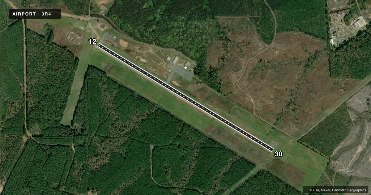
Runways & pattern
Full pagePattern entry · RWY 12
LEFT TRAFFICRunway end performance
| End | TORA | TODA | ASDA | LDA | VGSI | Approach lights | Obstruction |
|---|---|---|---|---|---|---|---|
| 12 | — | — | — | — | PAPI 2-box left(3°) | — | 38', trees, 1681' from thr, 227' R of cntrln, slope 38 |
| 30 | — | — | — | — | PAPI 2-box left(3.5°) | — | 78', trees, 1830' from thr, 0' R of cntrln, slope 20 |
Declared distances in feet. TORA = takeoff run available, TODA = takeoff distance, ASDA = accelerate-stop, LDA = landing distance.
Airport sketch
Runways drawn to scale from FAA survey coordinates, rendered over satellite imagery. Not for navigation.
Approaches & charts
Services on the field
Fuel grades, oxygen, maintenance, ramp storage and lighting — as declared to the FAA by the airport operator.
Fuel & services
- Fuel
- 100LL
- Oxygen (bottled)
- Not available
- Oxygen (bulk)
- Not available
- Airframe repair
- Not available
- Power plant repair
- Not available
- Other services
- INSTR
Ramp & ground
- Transient storage
- Tie-down
- Landing fee
- No fee published
- Customs
- Not available
- Lighting schedule
- SEE RMK
- Beacon schedule
- SS-SR
- Beacon
- White / Green (civil land)(WG)
- Wind indicator
- Lighted
- Segmented circle
- No
Fuel & FBOs
Cheapest 100LL and Jet A on the field and nearby. Always confirm with the FBO before taxi.
Airport notes
Surface conditions, obstructions, local procedures, lighting outages and other notes published with each FAA cycle.
General notes
- GCO AVBL ON FREQ 135.075 THRU MAKS APCH AND DE RIDDER FSS.
- FOR CD CTC IF UNA VIA GCO CTC MAKS APCH AT 726-780-0456.
- CTC APRT MGR FOR DSGND RAMP SPACE FOR PUB USE.
Lighting notes
- BCN LCTD .44 MI FM APCH END RWY 12.
- DUSK-DAWN. MIRL RY 12/30, REIL RYS 12 & 30 PRESET LOW INTST DUSK-DAWN; TO INCR INTST ACTVT - CTAF.
Fuel notes
- 100LLSELF SERVICE FUEL AVBL AFT HRS WITH CREDIT CARD.
Other notes
- PRE-DATES ACT.
VFR map & nearby airports
VFR sectional. Tap any ICAO chip to open that airport.
Key facts · 3R4
Answer card- ICAO
- 3R4
- Name
- HART
- Location
- MANY, LOUISIANA
- Elevation
- 318.5 ft MSL
- Traffic pattern altitude
- 1,318.5 ft MSL (1,000 AGL)
- Control tower
- Non-towered (use CTAF)
- Total runways
- 1
- Longest runway
- 12/30 · 4,402 ft
- Published ILS approaches
- 0
- Published frequencies
- 4
- Magnetic variation
- 4°
- Current flight rules
- VFR
- Current wind
- 000° at 0 kt
- Favored runway now
- –
HART is in Many, Louisiana. The field elevation is 318.5 ft MSL. It has one runway. The longest runway is 12/30 at 4,402 ft of asphalt. There is no control tower. No ILS approaches are published here. The pattern altitude is not published, so use the standard 1,000 ft AGL for light piston traffic unless the current Chart Supplement says otherwise.
This is a non-towered field with CTAF and UNICOM on 122.8. MAKS Approach is listed on 123.7 and 261.3. Published remarks say runway 12/30 has medium intensity lighting. The runway end identifier lights on 12 and 30 are preset to low intensity from dusk to dawn. Use 122.8 to increase light intensity. Self-service 100LL is available after hours with a credit card. There is also a ground communications outlet on 135.075 through MAKS Approach and De Ridder Flight Service Station.
If you need clearance delivery and cannot get it through the ground communications outlet, contact MAKS Approach. The airport manager handles designated ramp space for public use. Pilots should plan for a non-towered environment and verify any current procedures in the current FAA Chart Supplement before arrival.