METAR & TAF KIER
Current METAR
Observed 13:35Z
KIER 271335Z AUTO 00000KT 10SM CLR 28/25 A3001 RMK AO2 T02780247
- Wind
- 000° @ 0 kt
- Visibility
- 10 SM
- Temp / Dew
- 28°C / 25°C
- Altimeter
- 30.01 inHg
- Clouds
- CLR
- Density alt
- 1,598 ft
- Ceiling
- Unlimited
- Rules
- VFR
Airport info & contacts
Manager on record, flight service, ARTCC, attendance schedule and pattern altitude — published by the FAA and refreshed every 28 days.
Location
- From city
- 2 NM S
- VFR sectional
- HOUSTON
- ARTCC
- ZHU · HOUSTON
- NOTAM facility
- IER (NOTAM-D)
Airport manager
- Name
- JUSTIN FOSHEE
- Phone
- 318-352-0994
- Address
- 450 WALLENBERG DRIVE, NATCHITOCHES LA 71457
Flight service · Hours
- FSS DRI
- DE RIDDER1-800-WX-BRIEF
- Attendance
- DAWN-DUSK
Frequencies
Tap any row to copy the frequency to your clipboard.
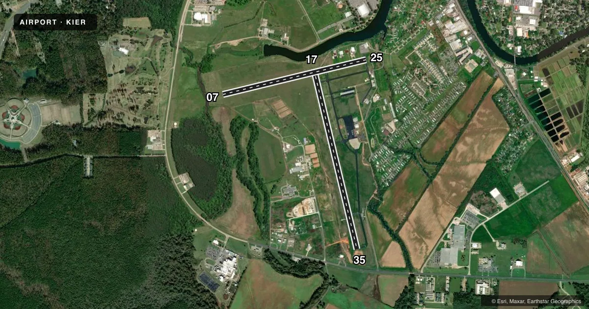
Runways & pattern
Full pagePattern entry · RWY 17
LEFT TRAFFIC| Runway | Heading (°M) | Length | Surface | Traffic |
|---|---|---|---|---|
| 17/35 | 162° / 342° | 5,003 ft | ASPH | Standard L |
| 07/25 | 72° / 252° | 4,000 ft | ASPH | Standard L |
Runway end performance
| End | TORA | TODA | ASDA | LDA | VGSI | Approach lights | Obstruction |
|---|---|---|---|---|---|---|---|
| 17 | — | — | — | — | PAPI 4-box left(3°) | — | 82', tree, 3600' from thr, slope 41 |
| 35 | — | — | — | — | PAPI 4-box left(3°) | ODALS | 106', trees, 3612' from thr, 0' R of cntrln, slope 32 |
| 07 | — | — | — | — | PAPI 2-box left(3°) | — | 98', trees, 2049' from thr, 142' R of cntrln, slope 18 |
| 25 | — | — | — | — | PAPI 2-box left(3°) | — | 82', tree, 2091' from thr, 0' R of cntrln, slope 23 |
Declared distances in feet. TORA = takeoff run available, TODA = takeoff distance, ASDA = accelerate-stop, LDA = landing distance.
Airport sketch
Runways drawn to scale from FAA survey coordinates, rendered over satellite imagery. Not for navigation.
Approaches & charts
ILS · 1
Services on the field
Fuel grades, oxygen, maintenance, ramp storage and lighting — as declared to the FAA by the airport operator.
Fuel & services
- Fuel
- 100LLA1+
- Oxygen (bottled)
- Not available
- Oxygen (bulk)
- Not available
- Airframe repair
- Major
- Power plant repair
- Major
- Other services
- AGRI,AMB,CHTR,INSTR,SURV
Ramp & ground
- Transient storage
- Tie-down
- Hangar
- Landing fee
- No fee published
- Customs
- Not available
- Lighting schedule
- SEE RMK
- Beacon schedule
- SS-SR
- Beacon
- White / Green (civil land)(WG)
- Wind indicator
- Lighted
- Segmented circle
- No
Fuel & FBOs
Cheapest 100LL and Jet A on the field and nearby. Always confirm with the FBO before taxi.
Airport notes
Surface conditions, obstructions, local procedures, lighting outages and other notes published with each FAA cycle.
General notes
- GCO AVBL ON FREQ 135.075 THRU MAKS APCH - 4 CLICKS; AND FSS - 6 CLICKS.
- FOR CD IF UNA VIA GCO CTC MAKS APCH AT 726-780-0456.
- CTC ARPT MGR FOR DSNGD RAMP SPACE FOR PUB USE AT ARPT
Lighting notes
- ODALS RWY 35; REIL RWY 07 AND RWY 17 PRESET LOW INTST CONSLY, TO INCR INTST ACTVT - CTAF. MIRL RWY 17/35 AND RWY 7/25 PRESET LOW INTST DUSK TO DAWN, TO INCR INTST ACTVT - CTAF
Fuel notes
- 100LLFUEL AVBL 24/7 WITH CC.
Other notes
- 1FOR ARPT ATTENDANT AFT HRS CALL 318-471-2106.
VFR map & nearby airports
VFR sectional. Tap any ICAO chip to open that airport.
Key facts · KIER
Answer card- ICAO
- KIER
- Name
- NATCHITOCHES RGNL
- Location
- NATCHITOCHES, LOUISIANA
- Elevation
- 121 ft MSL
- Traffic pattern altitude
- 1,121 ft MSL (1,000 AGL)
- Control tower
- Non-towered (use CTAF)
- Total runways
- 2
- Longest runway
- 17/35 · 5,003 ft
- Published ILS approaches
- 1
- Published frequencies
- 4
- Magnetic variation
- 4°
- Current flight rules
- VFR
- Current wind
- 000° at 0 kt
- Favored runway now
- –
Natchitoches Regional Airport sits in Natchitoches, Louisiana. Field elevation is 121 ft MSL. The airport has two asphalt runways. Runway 17/35 is the longest at 5,003 ft. Runway 07/25 is 4,000 ft. The field is untowered, so expect self-announce traffic on CTAF 122.8. Pattern altitude is not published. Use the standard 1,000 ft AGL for light piston operations unless the current Chart Supplement says otherwise.
One ILS approach is published for runway 35. That matters here because runway 35 also has an omnidirectional approach lighting system. Runway end identifier lights are installed on runways 07 and 17. The runway lights on both runways are preset to low intensity from dusk to dawn. Use CTAF 122.8 to increase intensity when needed. A ground communications outlet is available through Maks Approach on 135.075 with 4 clicks. If that is not available, clearance delivery can be reached through Maks Approach by phone.
Natchitoches Regional Airport has one on-field FBO. Natchitoches Regional Airport carries 100LL and Jet A Prist. Fuel is available 24 hours a day with a credit card. For ramp space, contact the airport manager. First-time arrivals should plan for an untowered environment and verify current procedures in the FAA Chart Supplement before flying in.