METAR & TAF L39
L39 does not publish a METAR.
Showing the nearest reporting station: KDRI (BEAUREGARD RGNL) · 20.2 NM away. Conditions at L39 may differ.
METAR · KDRI
Observed 06:35Z
KDRI 270635Z AUTO 23004KT 10SM CLR 26/26 A3000 RMK AO2 T02640256 $
- Wind
- 230° @ 4 kt
- Visibility
- 10 SM
- Temp / Dew
- 26°C / 26°C
- Altimeter
- 30.00 inHg
- Clouds
- CLR
- Density alt
- 1,570 ft
- Ceiling
- Unlimited
- Rules
- VFR
Airport info & contacts
Manager on record, flight service, ARTCC, attendance schedule and pattern altitude — published by the FAA and refreshed every 28 days.
Location
- From city
- 4 NM W
- VFR sectional
- HOUSTON
- ARTCC
- ZHU · HOUSTON
- NOTAM facility
- DRI (NOTAM-D)
Airport manager
- Name
- PAUL JACKSON
- Phone
- 337-238-5968
- Address
- 424 AIRPORT ROAD, LEESVILLE LA 71446
Flight service · Hours
- FSS DRI
- DE RIDDER1-800-WX-BRIEF
- Attendance
- ALL
Frequencies
Tap any row to copy the frequency to your clipboard.
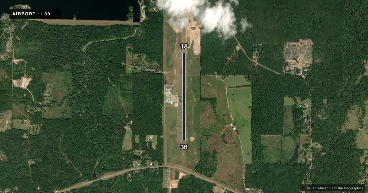
Runways & pattern
Full pagePattern entry · RWY 18
LEFT TRAFFICRunway end performance
| End | TORA | TODA | ASDA | LDA | VGSI | Approach lights | Obstruction |
|---|---|---|---|---|---|---|---|
| 18 | — | — | — | — | PAPI 2-box left(3°) | — | 58', trees, 872' from thr, slope 50 |
| 36 | — | — | — | — | PAPI 2-box left(3°) | — | 39', trees, 1596' from thr, 493' R of cntrln, slope 36 |
Declared distances in feet. TORA = takeoff run available, TODA = takeoff distance, ASDA = accelerate-stop, LDA = landing distance.
Airport sketch
Runways drawn to scale from FAA survey coordinates, rendered over satellite imagery. Not for navigation.
Approaches & charts
Services on the field
Fuel grades, oxygen, maintenance, ramp storage and lighting — as declared to the FAA by the airport operator.
Fuel & services
- Fuel
- 100LLA
- Oxygen (bottled)
- Not available
- Oxygen (bulk)
- Not available
- Other services
- INSTR
Ramp & ground
- Transient storage
- Tie-down
- Hangar
- Landing fee
- No fee published
- Customs
- Not available
- Lighting schedule
- SEE RMK
- Beacon schedule
- SS-SR
- Beacon
- White / Green (civil land)(WG)
- Wind indicator
- Lighted
- Segmented circle
- No
Fuel & FBOs
Cheapest 100LL and Jet A on the field and nearby. Always confirm with the FBO before taxi.
Airport notes
Surface conditions, obstructions, local procedures, lighting outages and other notes published with each FAA cycle.
General notes
- RWY 18/36 15 FT TERRAIN DROP EAST SIDE OF RWY.
- WILDLIFE ON & INVOF ARPT.
- USE RWY END TURNABOUTS TO AVOID LOCKED WHEEL AND SHARP TURNS ON RWY SFC.
- FOR CD CTC MAKS APCH AT 726-780-0456.
- CTC ARPT MGR FOR DSNGD RAMP SPACE FOR PUB USE AT ARPT
Lighting notes
- DUSK-DAWN. MIRL RWY 18/36, REIL RYS 18 & 36 PRESET LOW INTST DUSK-DAWN; TO INCR INTST ACTVT - CTAF 122.8.
Fuel notes
- 100LLFUEL AVBL 24 HRS WITH CREDIT CARD.
Other notes
- 1FUEL, RESTROOM & TERMINAL LOBBY AVAILABLE 24/7. MANAGER HOURS PART-TIME ON CALL.
VFR map & nearby airports
VFR sectional. Tap any ICAO chip to open that airport.
Key facts · L39
Answer card- ICAO
- L39
- Name
- LEESVILLE
- Location
- LEESVILLE, LOUISIANA
- Elevation
- 281.5 ft MSL
- Traffic pattern altitude
- 1,281.5 ft MSL (1,000 AGL)
- Control tower
- Non-towered (use CTAF)
- Total runways
- 1
- Longest runway
- 18/36 · 3,807 ft
- Published ILS approaches
- 0
- Published frequencies
- 4
- Magnetic variation
- 2°
- Current flight rules
- VFR
- Current wind
- 230° at 4 kt
- Favored runway now
- RWY 18
Leesville Airport is in Leesville, Louisiana. The field elevation is 281.5 ft MSL. It has one runway, 18/36, which is 3,807 ft long. There is no control tower. No ILS approaches are published. The pattern altitude is not published, so use the standard 1,000 ft AGL for light piston traffic unless local guidance says otherwise.
The on-field FBO is Leesville Airport. It carries 100LL, Jet A and Jet A Prist. Fuel is available 24 hours with a credit card. The terminal lobby and restroom are also available 24 hours a day. Manager hours are part-time and on call. For clearance delivery, contact MAKS Approach at 726-780-0456.
A few operational notes matter here. Runway lights are dusk to dawn. Medium intensity lights are on runway 18/36. Runway end identifier lights are preset to low intensity at night. Use CTAF 122.8 if you need to increase lighting intensity. The FAA remarks also call out wildlife on and near the airport. Runway 18/36 has a 15 ft terrain drop on the east side. Use the runway end turnabouts to avoid locked wheel and sharp turns on the surface. If you need ramp space for public use, contact the airport manager first.