METAR & TAF 61R
61R does not publish a METAR.
Showing the nearest reporting station: KJAS (JASPER COUNTY/BELL FLD) · 15.1 NM away. Conditions at 61R may differ.
METAR · KJAS
Observed 21:35Z
KJAS 262135Z AUTO 20005KT 10SM CLR 34/24 A2999 RMK AO2
- Wind
- 200° @ 5 kt
- Visibility
- 10 SM
- Temp / Dew
- 34°C / 24°C
- Altimeter
- 29.99 inHg
- Clouds
- CLR
- Density alt
- 2,592 ft
- Ceiling
- Unlimited
- Rules
- VFR
Airport info & contacts
Manager on record, flight service, ARTCC, attendance schedule and pattern altitude — published by the FAA and refreshed every 28 days.
Location
- From city
- 3 NM NE
- VFR sectional
- HOUSTON
- ARTCC
- ZHU · HOUSTON
- NOTAM facility
- CXO (NOTAM-D)
Airport manager
- Name
- RONALD J. COCHRAN
- Phone
- 409-379-5691
- Address
- PO BOX 1380, NEWTON TX 75966
Flight service · Hours
- FSS CXO
- MONTGOMERY COUNTY1-800-WX-BRIEF
- Attendance
- Unattended
Frequencies
Tap any row to copy the frequency to your clipboard.
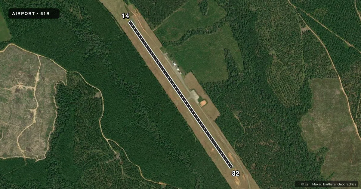
Runways & pattern
Full pagePattern entry · RWY 14
LEFT TRAFFICRunway end performance
| End | TORA | TODA | ASDA | LDA | VGSI | Approach lights | Obstruction |
|---|---|---|---|---|---|---|---|
| 14 | — | — | — | — | — | — | 65', trees, 1650' from thr, 315' R of cntrln, slope 22 |
| 32 | — | — | — | — | — | — | 75', trees, 675' from thr, 175' R of cntrln, slope 6 |
Declared distances in feet. TORA = takeoff run available, TODA = takeoff distance, ASDA = accelerate-stop, LDA = landing distance.
Airport sketch
Runways drawn to scale from FAA survey coordinates, rendered over satellite imagery. Not for navigation.
Approaches & charts
Services on the field
Fuel grades, oxygen, maintenance, ramp storage and lighting — as declared to the FAA by the airport operator.
Fuel & services
- Fuel
- Not available
- Oxygen (bottled)
- Not available
- Oxygen (bulk)
- Not available
Ramp & ground
- Transient storage
- Not published
- Landing fee
- No fee published
- Customs
- Not available
- Lighting schedule
- SS-SR
- Beacon schedule
- SS-SR
- Beacon
- White / Green (civil land)(WG)
- Wind indicator
- Lighted
- Segmented circle
- Yes
Fuel & FBOs
Cheapest 100LL and Jet A on the field and nearby. Always confirm with the FBO before taxi.
Airport notes
Surface conditions, obstructions, local procedures, lighting outages and other notes published with each FAA cycle.
General notes
- FOR CD CTC MAKS APCH AT 726-780-0456.
Other notes
- MANAGERCOUNTY JUDGE/AMGR
VFR map & nearby airports
VFR sectional. Tap any ICAO chip to open that airport.
Key facts · 61R
Answer card- ICAO
- 61R
- Name
- NEWTON MUNI
- Location
- NEWTON, TEXAS
- Elevation
- 322 ft MSL
- Traffic pattern altitude
- 1,322 ft MSL (1,000 AGL)
- Control tower
- Non-towered (use CTAF)
- Total runways
- 1
- Longest runway
- 14/32 · 4,000 ft
- Published ILS approaches
- 0
- Published frequencies
- 2
- Magnetic variation
- 5°
- Current flight rules
- VFR
- Current wind
- 200° at 5 kt
- Favored runway now
- RWY 14
Newton Muni is in Newton, Texas. The field elevation is 322 ft MSL. It has one runway. Runway 14/32 is 4,000 ft long with asphalt pavement. The airport is not towered. CTAF and UNICOM are both 122.8. No ILS approaches are published here.
The pattern altitude is not published in the facts, so use the standard 1,000 ft AGL pattern for light piston traffic unless the current FAA Chart Supplement says otherwise. For this field, that puts the pattern at about 1,322 ft MSL. The published remarks also say the county judge is the airport manager. For clearance delivery, contact MAKS Approach at 726-780-0456. After hours airport manager contact is 409-384-0722.
There are no on-field FBOs listed in the facts. Contact the airport operator directly before arrival. You can also call the field on CTAF or UNICOM for current FBO availability. If you are planning a first visit, treat this as a non-towered airport with a single 4,000 ft runway. Verify current local procedures, traffic flow and any airport-specific restrictions in the current FAA Chart Supplement before you go.