METAR & TAF T12
T12 does not publish a METAR.
Showing the nearest reporting station: KJAS (JASPER COUNTY/BELL FLD) · 15.6 NM away. Conditions at T12 may differ.
METAR · KJAS
Observed 10:15Z
KJAS 271015Z AUTO 00000KT 4SM BR CLR 24/24 A2998 RMK AO2
- Wind
- 000° @ 0 kt
- Visibility
- 4 SM
- Temp / Dew
- 24°C / 24°C
- Altimeter
- 29.98 inHg
- Clouds
- CLR
- Density alt
- 1,156 ft
- Ceiling
- Unlimited
- Rules
- MVFR
Airport info & contacts
Manager on record, flight service, ARTCC, attendance schedule and pattern altitude — published by the FAA and refreshed every 28 days.
Location
- From city
- 2 NM SW
- VFR sectional
- HOUSTON
- ARTCC
- ZHU · HOUSTON
- NOTAM facility
- CXO (NOTAM-D)
Airport manager
- Name
- CHRIS RUIZ
- Phone
- 409-384-5343
- Address
- JASPER COUNTY COURTHOUSE, 121 N AUSTIN ST, JASPER TX 75951
Flight service · Hours
- FSS CXO
- MONTGOMERY COUNTY1-800-WX-BRIEF
- Attendance
- Unattended
Frequencies
Tap any row to copy the frequency to your clipboard.
Runways & pattern
Full pagePattern entry · RWY 13
LEFT TRAFFIC| Runway | Heading (°M) | Length | Surface | Traffic |
|---|---|---|---|---|
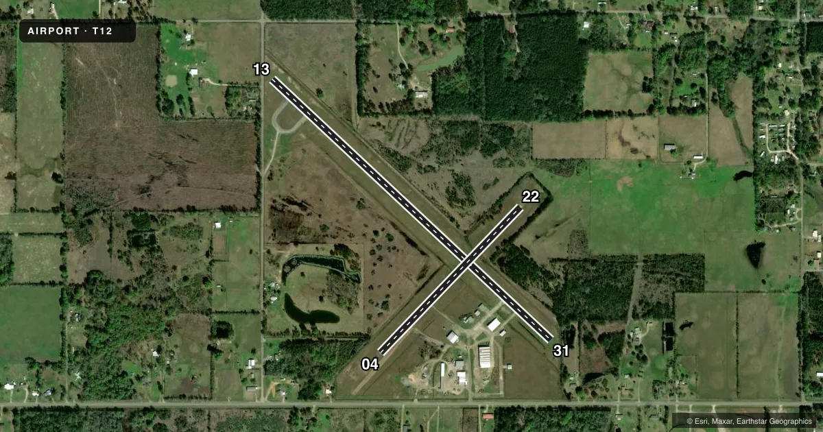
| 13/31 | 128° / 307° | 3,746 ft | ASPH | Standard L |
| 04/22 | 39° / 219° | 1,983 ft | ASPH | Standard L |
Runway end performance
| End | TORA | TODA | ASDA | LDA | VGSI | Approach lights | Obstruction |
|---|---|---|---|---|---|---|---|
| 13 | — | — | — | — | — | — | 5', fence, 201' from thr, 125' R of cntrln, slope 0 |
| 31 | — | — | — | — | — | — | 34', trees, 213' from thr, 65' R of cntrln, slope 0 |
| 04 | — | — | — | — | — | — | 50', trees, 570' from thr, 105' R of cntrln, slope 7 |
| 22 | — | — | — | — | — | — | 60', trees, 275' from thr, 145' R of cntrln, slope 1 |
Declared distances in feet. TORA = takeoff run available, TODA = takeoff distance, ASDA = accelerate-stop, LDA = landing distance.
Airport sketch
Runways drawn to scale from FAA survey coordinates, rendered over satellite imagery. Not for navigation.
Approaches & charts
Services on the field
Fuel grades, oxygen, maintenance, ramp storage and lighting — as declared to the FAA by the airport operator.
Fuel & services
- Fuel
- Not available
- Airframe repair
- Not available
- Power plant repair
- Not available
Ramp & ground
- Transient storage
- Not published
- Landing fee
- No fee published
- Customs
- Not available
- Wind indicator
- Yes
- Segmented circle
- No
Fuel & FBOs
Cheapest 100LL and Jet A on the field and nearby. Always confirm with the FBO before taxi.
Airport notes
Surface conditions, obstructions, local procedures, lighting outages and other notes published with each FAA cycle.
General notes
- PAEW DURG DALGT.
- DEER ON AND INVOF ARPT.
- FOR CD CTC HOUSTON ARTCC AT 281-230-5622.
- RWY 4/21 MKD W/ LARGE YELLOW X AT EACH END.
- RWY 4, 8 FT DIRT PILE ON RWY END.
Runway surface & condition
- 04/22RWY 04/22 CLSD INDEFLY.
Approach & departure obstructions
- 045 FT FENCE, 0 FT DSTC, 100 FT L.
- 134 FT FENCE, 0 FT DSTC AT 97 FT R.
- 3110-30 FT TREES 50-199 FT DSTC.
- 13OBSTN CLNC SLOPE 5:1 TO DSPLCD THLD OVR 57 FT TREE, 337 F DSTC, 157 FT R.
- 31OBSTN CLNC SLOPE 5:1 TO DSPLCD THLD OVR 50 FT TREES, 275 FT DSTC, 107 FT R.
Other notes
- THIS AIRPORT HAS BEEN SURVEYED BY THE NATIONAL GEODETIC SURVEY.
- PRE DATES THE ACT.
- 04/22RWY NOT SUITABLE FOR ACFT, ROUGH & UNEVEN, LOOSE STONES ON RWY, VEGETATION GROWING. DIRT PILES ADJACENT.
VFR map & nearby airports
VFR sectional. Tap any ICAO chip to open that airport.
Key facts · T12
Answer card- ICAO
- T12
- Name
- KIRBYVILLE
- Location
- KIRBYVILLE, TEXAS
- Elevation
- 121 ft MSL
- Traffic pattern altitude
- 1,121 ft MSL (1,000 AGL)
- Control tower
- Non-towered (use CTAF)
- Total runways
- 2
- Longest runway
- 13/31 · 3,746 ft
- Published ILS approaches
- 0
- Published frequencies
- 1
- Magnetic variation
- 5°
- Current flight rules
- MVFR
- Current wind
- 000° at 0 kt
- Favored runway now
- –
KIRBYVILLE (T12) sits in Kirbyville, Texas. Field elevation is 121 ft MSL. The airport has two runways. The longest is runway 13/31 at 3,746 ft. Runway 04/22 is 1,983 ft. The published remarks say it is closed indefinitely and not suitable for aircraft. The field is non-towered. CTAF is 122.9. No ILS approaches are published.
Pattern altitude is not published. Use the standard 1,000 ft AGL for light piston operations unless the current Chart Supplement says otherwise. That puts the traffic pattern at about 1,121 ft MSL here. The published remarks also call out deer on and near the airport. There are obstructions near both ends of the runways. Runway 31 has trees near the departure end. Runway 04 has a fence near the end. Runway 13 has a fence near the end.
There are no on-field FBOs listed. Plan on verifying services before you go. If you need clearance delivery, the published remark says to contact Houston ARTCC at 281-230-5622. For a first-time arrival, treat this as a small non-towered field with limited published instrument support. Check the current Chart Supplement for any updated runway status or local operating notes before you fly in.