METAR & TAF KJAS
Current METAR
Observed 08:35Z
KJAS 270835Z AUTO 00000KT 7SM CLR 24/24 A2997 RMK AO2
- Wind
- 000° @ 0 kt
- Visibility
- 7 SM
- Temp / Dew
- 24°C / 24°C
- Altimeter
- 29.97 inHg
- Clouds
- CLR
- Density alt
- 1,282 ft
- Ceiling
- Unlimited
- Rules
- VFR
Airport info & contacts
Manager on record, flight service, ARTCC, attendance schedule and pattern altitude — published by the FAA and refreshed every 28 days.
Location
- From city
- 4 NM SW
- VFR sectional
- HOUSTON
- ARTCC
- ZHU · HOUSTON
- NOTAM facility
- JAS (NOTAM-D)
Airport manager
- Name
- CHRIS RUIZ
- Phone
- 409-384-5343
- Address
- 193 CARNES B MANNING DR, JASPER TX 75951
Flight service · Hours
- FSS CXO
- MONTGOMERY COUNTY1-800-WX-BRIEF
- Attendance
- 0800-1700
Frequencies
Tap any row to copy the frequency to your clipboard.
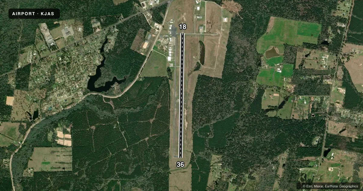
Runways & pattern
Full pagePattern entry · RWY 18
LEFT TRAFFICRunway end performance
| End | TORA | TODA | ASDA | LDA | VGSI | Approach lights | Obstruction |
|---|---|---|---|---|---|---|---|
| 18 | — | — | — | — | PAPI 2-box left(3.5°) | — | 90', trees, 2550' from thr, 1265' R of cntrln, slope 26 |
| 36 | — | — | — | — | PAPI 2-box left(3.5°) | — | 80', trees, 1980' from thr, 550' R of cntrln, slope 24 |
Declared distances in feet. TORA = takeoff run available, TODA = takeoff distance, ASDA = accelerate-stop, LDA = landing distance.
Airport sketch
Runways drawn to scale from FAA survey coordinates, rendered over satellite imagery. Not for navigation.
Approaches & charts
Services on the field
Fuel grades, oxygen, maintenance, ramp storage and lighting — as declared to the FAA by the airport operator.
Fuel & services
- Fuel
- 100LLA
- Oxygen (bottled)
- Not available
- Oxygen (bulk)
- Not available
- Airframe repair
- Major
- Power plant repair
- Major
- Other services
- INSTR,RNTL
Ramp & ground
- Transient storage
- Tie-down
- Hangar
- Landing fee
- No fee published
- Customs
- Not available
- Lighting schedule
- SEE RMK
- Beacon schedule
- SS-SR
- Beacon
- White / Green (civil land)(WG)
- Wind indicator
- Lighted
- Segmented circle
- Yes
Fuel & FBOs
Cheapest 100LL and Jet A on the field and nearby. Always confirm with the FBO before taxi.
Airport notes
Surface conditions, obstructions, local procedures, lighting outages and other notes published with each FAA cycle.
General notes
- FOR CD IF UNA TO CTC ON FSS FREQ, CTC HOUSTON ARTCC AT 281-230-5622.
Lighting notes
- MIRL RWY 18/36 PRESET LOW INTST; TO INCR INTST ACTVT - CTAF.
Other notes
- THIS AIRPORT HAS BEEN SURVEYED BY THE NATIONAL GEODETIC SURVEY.
- MANAGEREMER AFT HRS 409-382-2835
VFR map & nearby airports
VFR sectional. Tap any ICAO chip to open that airport.
Key facts · KJAS
Answer card- ICAO
- KJAS
- Name
- JASPER COUNTY/BELL FLD
- Location
- JASPER, TEXAS
- Elevation
- 212.6 ft MSL
- Traffic pattern altitude
- 1,212.6 ft MSL (1,000 AGL)
- Control tower
- Non-towered (use CTAF)
- Total runways
- 1
- Longest runway
- 18/36 · 5,500 ft
- Published ILS approaches
- 0
- Published frequencies
- 2
- Magnetic variation
- 4°
- Current flight rules
- VFR
- Current wind
- 000° at 0 kt
- Favored runway now
- –
Jasper County/Bell Fld is in Jasper, Texas. The field elevation is 212.6 ft MSL. It has one runway, 18/36, which is 5,500 ft long with asphalt pavement. There is no control tower. CTAF and UNICOM are both 122.8.
No ILS approaches are published here. Pattern altitude is not published, so plan on the standard 1,000 ft AGL for light piston operations unless the current FAA Chart Supplement says otherwise. The runway lighting on 18/36 is medium intensity. It comes up preset to low intensity. Use the CTAF to increase it.
Bravo Aviation is on the field. It carries 100LL and Jet A. If you need local help after hours, the published emergency number is in the Chart Supplement remarks. For clearance delivery issues, the published note points pilots to Houston ARTCC if Flight Service cannot be reached on the usual frequency.
This is an uncontrolled field, so keep your radio work tight and watch for local traffic. The airport has been surveyed by the National Geodetic Survey. Check the current FAA Chart Supplement for any changes before you go.