METAR & TAF 5R8
Current METAR
Observed 06:35Z
K5R8 270635Z AUTO 00000KT 10SM CLR A3000 RMK AO2
- Wind
- 000° @ 0 kt
- Visibility
- 10 SM
- Temp / Dew
- —
- Altimeter
- 30.00 inHg
- Clouds
- CLR
- Density alt
- —
- Ceiling
- Unlimited
- Rules
- VFR
Airport info & contacts
Manager on record, flight service, ARTCC, attendance schedule and pattern altitude — published by the FAA and refreshed every 28 days.
Location
- From city
- 2 NM SW
- VFR sectional
- HOUSTON
- ARTCC
- ZHU · HOUSTON
- NOTAM facility
- 5R8 (NOTAM-D)
Airport manager
- Name
- KYLE RAINWATER
- Phone
- 337-660-3488
- Address
- PO BOX 968, DE QUINCY LA 70633
Flight service · Hours
- FSS DRI
- DE RIDDER1-800-WX-BRIEF
- Attendance
- MON-THURS · 0700-1600
- FRI · 0700-1100
Frequencies
Tap any row to copy the frequency to your clipboard.
Runways & pattern
Full pagePattern entry · RWY 16
LEFT TRAFFICRunway end performance
| End | TORA | TODA | ASDA | LDA | VGSI | Approach lights | Obstruction |
|---|---|---|---|---|---|---|---|
| 16 | — | — | — | — | PAPI 2-box left(3°) | — | 59', tree, 1468' from thr, 0' R of cntrln, slope 21 |
| 34 | — | — | — | — | PAPI 2-box left(3°) | — | 43', trees, 1573' from thr, 280' R of cntrln, slope 31 |
Declared distances in feet. TORA = takeoff run available, TODA = takeoff distance, ASDA = accelerate-stop, LDA = landing distance.
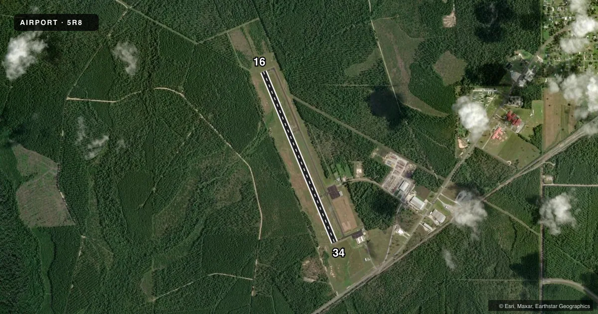
Airport sketch
Runways drawn to scale from FAA survey coordinates, rendered over satellite imagery. Not for navigation.
Approaches & charts
Services on the field
Fuel grades, oxygen, maintenance, ramp storage and lighting — as declared to the FAA by the airport operator.
Fuel & services
- Fuel
- 100LL
- Oxygen (bottled)
- Not available
- Oxygen (bulk)
- Not available
- Airframe repair
- Minor
- Power plant repair
- Minor
- Other services
- AGRI
Ramp & ground
- Transient storage
- Tie-down
- Hangar
- Landing fee
- No fee published
- Customs
- Not available
- Lighting schedule
- SEE RMK
- Beacon schedule
- SS-SR
- Beacon
- White / Green (civil land)(WG)
- Wind indicator
- Lighted
- Segmented circle
- Yes
Fuel & FBOs
Cheapest 100LL and Jet A on the field and nearby. Always confirm with the FBO before taxi.
Airport notes
Surface conditions, obstructions, local procedures, lighting outages and other notes published with each FAA cycle.
General notes
- FOR CD CTC LAKE CHARLES APCH AT 337-480-3103, WHEN APCH CLSD CTC HOUSTON ARTCC AT 281-230-5622.
- COURTESY CAR AND PILOTS LOUNGE AVBL.
- CTC APRT MGR FOR DSGND RAMP SPACE FOR PUB USE.
Lighting notes
- MIRL RY 16/34, REIL RYS 16 & 34 PRESET LOW INTST DUSK-DAWN; TO INCR INTST ACTVT - CTAF.
Fuel notes
- 100LLSELF SERVICE FUEL WITH CREDIT CARD.
Other notes
- EMERG AIRFRAME RPR AVBL CALL ARPT MGR FOR DETAILS.
- EMERG PWR PLANT RPR AVBL CALL ARPT MGR FOR DETAILS.
- MUST PRVD ROPE AND CAULKS
VFR map & nearby airports
VFR sectional. Tap any ICAO chip to open that airport.
Key facts · 5R8
Answer card- ICAO
- 5R8
- Name
- DE QUINCY INDUSTRIAL AIRPARK
- Location
- DE QUINCY, LOUISIANA
- Elevation
- 82.8 ft MSL
- Traffic pattern altitude
- 1,082.8 ft MSL (1,000 AGL)
- Control tower
- Non-towered (use CTAF)
- Total runways
- 1
- Longest runway
- 16/34 · 4,997 ft
- Published ILS approaches
- 0
- Published frequencies
- 4
- Magnetic variation
- 2°
- Current flight rules
- VFR
- Current wind
- 000° at 0 kt
- Favored runway now
- –
De Quincy Industrial Airpark sits in DeQuincy, Louisiana. Field elevation is 82.8 ft MSL. The airport has one asphalt runway, 16/34, at 4,997 ft. It is an untowered field. Pattern altitude is not published, so use 1,000 ft AGL for light piston operations unless local guidance says otherwise.
No ILS approaches are published here. CTAF and UNICOM are both 122.8. Lake Charles Approach handles clearance delivery and approach or departure services on 119.35 and 282.3. If Approach is closed, contact Houston ARTCC for clearance delivery. The field has medium intensity runway lights on 16/34. The runway end identifier lights on 16 and 34 are preset to low intensity from dusk to dawn. Use CTAF to increase lighting intensity.
The on-field FBO is DeQuincy Industrial Airpark. It carries AVGAS 100LL. Self-serve fuel with credit card is available. The published remarks also note that you must provide rope and caulks. A courtesy car and pilots lounge are available. Contact the airport manager for designated ramp space for public use. For a first visit, plan ahead for ramp handling and lighting setup. This is a small untowered field with a single runway, so standard self-announce discipline matters.