METAR & TAF KUXL
Current METAR
Observed 06:35Z
KUXL 270635Z AUTO 22004KT 10SM CLR 26/25 A2998 RMK AO2 T02640252 $
- Wind
- 220° @ 4 kt
- Visibility
- 10 SM
- Temp / Dew
- 26°C / 25°C
- Altimeter
- 29.98 inHg
- Clouds
- CLR
- Density alt
- 1,258 ft
- Ceiling
- Unlimited
- Rules
- VFR
Airport info & contacts
Manager on record, flight service, ARTCC, attendance schedule and pattern altitude — published by the FAA and refreshed every 28 days.
Location
- From city
- 5 NM S
- VFR sectional
- HOUSTON
- ARTCC
- ZHU · HOUSTON
- NOTAM facility
- UXL (NOTAM-D)
Airport manager
- Name
- TIM LAFLEUR
- Phone
- 337-607-4550
- Address
- 7000 SOUTHLAND FIELD ROAD, SULPHUR LA 70665
Flight service · Hours
- FSS DRI
- DE RIDDER1-800-WX-BRIEF
- Attendance
- 0600-2000
Frequencies
Tap any row to copy the frequency to your clipboard.
Runways & pattern
Full pagePattern entry · RWY 15
LEFT TRAFFICRunway end performance
| End | TORA | TODA | ASDA | LDA | VGSI | Approach lights | Obstruction |
|---|---|---|---|---|---|---|---|
| 15 | — | — | — | — | PAPI 4-box left(3°) | ODALS | 33', tree, 991' from thr, 322' R of cntrln, slope 23 |
| 33 | — | — | — | — | PAPI 4-box left(3°) | — | 45', tree, 1758' from thr, 0' R of cntrln, slope 34 |
Declared distances in feet. TORA = takeoff run available, TODA = takeoff distance, ASDA = accelerate-stop, LDA = landing distance.
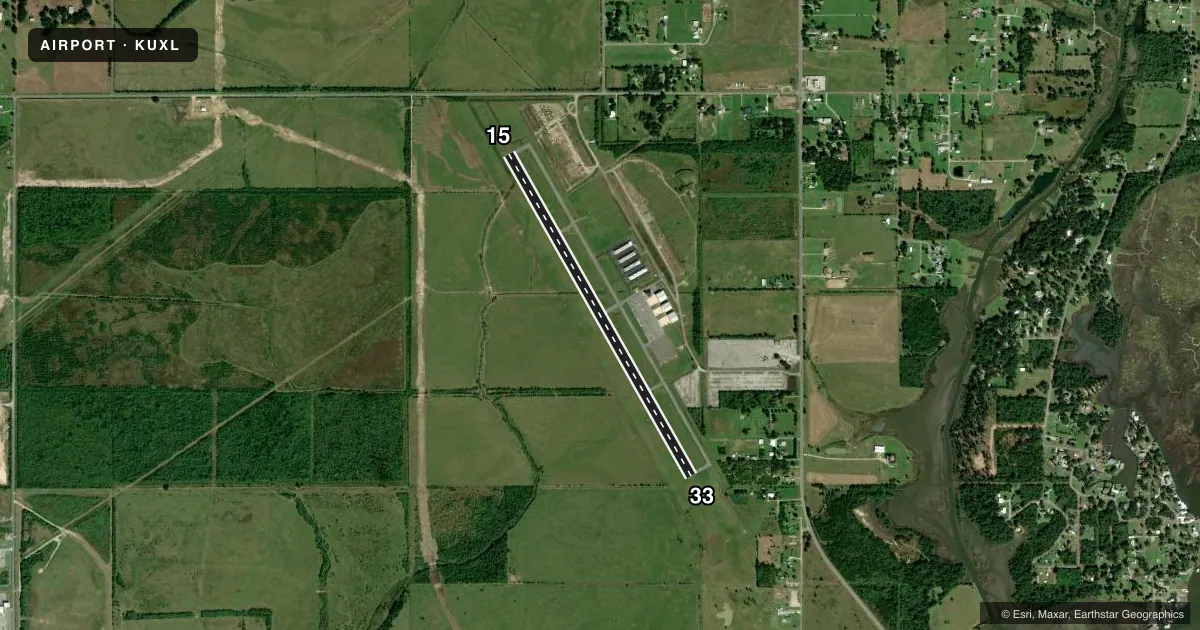
Airport sketch
Runways drawn to scale from FAA survey coordinates, rendered over satellite imagery. Not for navigation.
Approaches & charts
ILS · 1
Services on the field
Fuel grades, oxygen, maintenance, ramp storage and lighting — as declared to the FAA by the airport operator.
Fuel & services
- Fuel
- 100LLA
- Airframe repair
- Major
- Power plant repair
- Major
- Other services
- AGRI,INSTR,RNTL,SALES
Ramp & ground
- Transient storage
- Tie-down
- Hangar
- Lighting schedule
- SEE RMK
- Beacon schedule
- SS-SR
- Beacon
- White / Green (civil land)(WG)
- Wind indicator
- Lighted
- Segmented circle
- Yes
Fuel & FBOs
Cheapest 100LL and Jet A on the field and nearby. Always confirm with the FBO before taxi.
Airport notes
Surface conditions, obstructions, local procedures, lighting outages and other notes published with each FAA cycle.
General notes
- FOR CD CTC LAKE CHARLES APCH AT 337-480-3103, WHEN APCH CLSD CTC HOUSTON ARTCC AT 281-230-5622.
- CTC ARPT MGR FOR DSNGD RAMP SPACE FOR PUB USE AT ARPT
Lighting notes
- ODALS RWY 15; REIL RWY 33; MIRL RWY 15/33 PRESET LOW INTST DUSK-DAWN. TO INCR INTST - CTAF. PAPI RWY 15 & 33 OPR CONSLY.
Fuel notes
- 100LLFOR FUEL AFT HRS CALL 337-302-4280; FEE CHARGED.
Other notes
- THIS AIRPORT HAS BEEN SURVEYED BY THE NATIONAL GEODETIC SURVEY.
VFR map & nearby airports
VFR sectional. Tap any ICAO chip to open that airport.
Key facts · KUXL
Answer card- ICAO
- KUXL
- Name
- SOUTHLAND FLD
- Location
- SULPHUR, LOUISIANA
- Elevation
- 10.2 ft MSL
- Traffic pattern altitude
- 1,010.2 ft MSL (1,000 AGL)
- Control tower
- Non-towered (use CTAF)
- Total runways
- 1
- Longest runway
- 15/33 · 5,001 ft
- Published ILS approaches
- 1
- Published frequencies
- 4
- Magnetic variation
- 4°
- Current flight rules
- VFR
- Current wind
- 220° at 4 kt
- Favored runway now
- RWY 15
Southland Fld sits in Sulphur, Louisiana at 10.2 ft MSL. It has one runway. Runway 15/33 is 5,001 ft long with asphalt pavement. There is no control tower. Pattern altitude is not published, so plan on the standard 1,000 ft AGL for light piston traffic unless the current Chart Supplement says otherwise.
An ILS is published for runway 15. The field also has approach lighting for 15, runway end identifier lights for 33 and PAPI on both runway ends. The runway lights are medium intensity and are preset to low from dusk to dawn. Use CTAF if you need to increase intensity. Southland Aviation is on the field. It carries 100LL, Jet A and Jet A Prist. After-hours 100LL is available by phone call. A fee is charged.
For a first-time arrival, the main things to plan for are the low field elevation, the single runway layout and the published lighting setup. Clearance delivery is handled through Lake Charles Approach when it is open. If approach is closed, contact Houston ARTCC. Contact the airport manager for designated ramp space for public use before you go. Check the current FAA Chart Supplement for any noise or curfew restrictions before flying into the field.