METAR & TAF 3R7
Current METAR
Observed 05:35Z
K3R7 270535Z AUTO 00000KT 10SM CLR 27/25 A3001 RMK AO2 T02660249
- Wind
- 000° @ 0 kt
- Visibility
- 10 SM
- Temp / Dew
- 27°C / 25°C
- Altimeter
- 30.01 inHg
- Clouds
- CLR
- Density alt
- 1,357 ft
- Ceiling
- Unlimited
- Rules
- VFR
Airport info & contacts
Manager on record, flight service, ARTCC, attendance schedule and pattern altitude — published by the FAA and refreshed every 28 days.
Location
- From city
- 1 NM NW
- VFR sectional
- HOUSTON
- ARTCC
- ZHU · HOUSTON
- NOTAM facility
- DRI (NOTAM-D)
Airport manager
- Name
- DWAYNE BEBEE
- Phone
- 337-616-2370
- Address
- P.O.BOX 877, JENNINGS LA 70546
Flight service · Hours
- FSS DRI
- DE RIDDER1-800-WX-BRIEF
- Attendance
- MON-FRI · 0600-1600
Frequencies
Tap any row to copy the frequency to your clipboard.
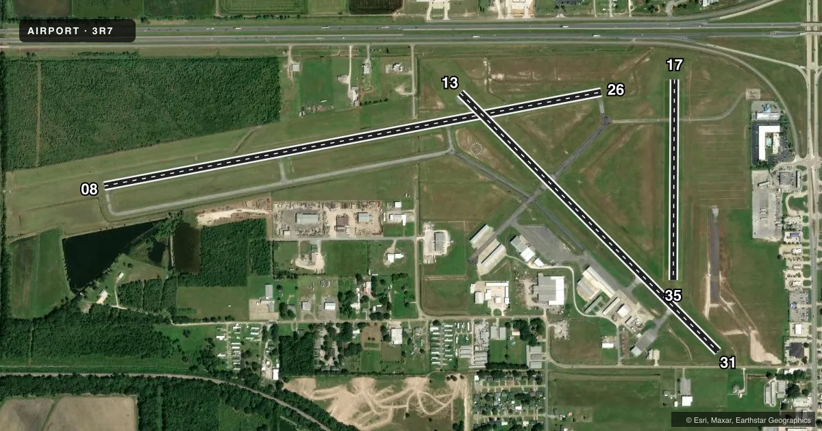
Runways & pattern
Full pagePattern entry · RWY 08
LEFT TRAFFIC| Runway | Heading (°M) | Length | Surface | Traffic |
|---|---|---|---|---|
| 08/26 | 77° / 257° | 5,002 ft | ASPH | 26 R |
| 13/31 | 133° / 313° | 3,601 ft | ASPH | 13 R |
| 17/35 | 178° / 358° | 1,977 ft | TURF | 17 R |
Runway end performance
| End | TORA | TODA | ASDA | LDA | VGSI | Approach lights | Obstruction |
|---|---|---|---|---|---|---|---|
| 08 | — | — | — | — | PAPI 2-box left(3°) | — | 36', trees, 1256' from thr, 1246' R of cntrln, slope 29 |
| 26 | — | — | — | — | PAPI 2-box left(3°) | — | 37', pole, 1407' from thr, 0' R of cntrln, slope 32 |
| 13 | — | — | — | — | PAPI 2-box left(3°) | — | 30', sign, 827' from thr, 110' R of cntrln, slope 21 |
| 31 | — | — | — | — | PAPI 2-box left(3°) | — | 17', bldg, 396' from thr, 109' R of cntrln, slope 11 |
| 17 | — | — | — | — | — | — | 35', pole, 682' from thr, 0' R of cntrln, slope 19 |
| 35 | — | — | — | — | — | — | 40', pline, 1200' from thr, 0' R of cntrln, slope 30 |
Declared distances in feet. TORA = takeoff run available, TODA = takeoff distance, ASDA = accelerate-stop, LDA = landing distance.
Airport sketch
Runways drawn to scale from FAA survey coordinates, rendered over satellite imagery. Not for navigation.
Approaches & charts
Services on the field
Fuel grades, oxygen, maintenance, ramp storage and lighting — as declared to the FAA by the airport operator.
Fuel & services
- Fuel
- 100LLA
- Oxygen (bottled)
- Not available
- Oxygen (bulk)
- Not available
- Other services
- AGRI,INSTR
Ramp & ground
- Transient storage
- Tie-down
- Hangar
- Landing fee
- No fee published
- Customs
- Not available
- Lighting schedule
- SEE RMK
- Beacon schedule
- SS-SR
- Beacon
- White / Green (civil land)(WG)
- Wind indicator
- Lighted
- Segmented circle
- No
Fuel & FBOs
Cheapest 100LL and Jet A on the field and nearby. Always confirm with the FBO before taxi.
Airport notes
Surface conditions, obstructions, local procedures, lighting outages and other notes published with each FAA cycle.
General notes
- 20 FT UNLGTD TWR 150 FT FM AER 35.
- ULTRALIGHT ACTVTY INVOF ARPT.
- NMRS AGRICULTURAL ACFT INVOF ARPT.
- FOR CD CTC HOUSTON ARTCC AT 281-230-5622.
- CTC ARPT MGR FOR RAMP SPACE DSNGD FOR PUB USE AT ARPT
Lighting notes
- ACTVT MIRL RWY 08/26, RWY 13/31 - CTAF.
Fuel notes
- 100LLSELF SERVICE FUEL AVBL AFT HRS WITH CREDIT CARD.
Approach & departure obstructions
- 315 FT FENCE & +15 FT ROAD 140 FT FM EOR.
- 17RWY 17/35 AND THLD OUTLINED WITH ORANGE CONES.
- 31APCH RATIO 21:1 FM DSPLCD THLD.
VFR map & nearby airports
VFR sectional. Tap any ICAO chip to open that airport.
Key facts · 3R7
Answer card- ICAO
- 3R7
- Name
- JENNINGS
- Location
- JENNINGS, LOUISIANA
- Elevation
- 22.8 ft MSL
- Traffic pattern altitude
- 1,022.8 ft MSL (1,000 AGL)
- Control tower
- Non-towered (use CTAF)
- Total runways
- 3
- Longest runway
- 08/26 · 5,002 ft
- Published ILS approaches
- 0
- Published frequencies
- 4
- Magnetic variation
- 2°
- Current flight rules
- VFR
- Current wind
- 000° at 0 kt
- Favored runway now
- –
Jennings Airport sits in Jennings, Louisiana. Field elevation is 22.8 ft MSL. The airport has three runways. The longest is runway 08/26 at 5,002 ft. There is no control tower, so use CTAF 122.8 for local traffic and lighting activation. No ILS approaches are published here.
Pattern altitude is not published. For light piston aircraft, plan on the standard 1,000 ft AGL unless the current Chart Supplement says otherwise. That puts the pattern at about 1,023 ft MSL based on the field elevation. Verify before you fly. The field uses CTAF activation for medium intensity lights on runways 08/26 and 13/31. Runway 17/35 is marked with orange cones. There is also a 5-foot fence and a road near the departure end of runway 31. The approach to 31 has a 21:1 ratio from the displaced threshold.
Two on-field FBOs are listed. Gulf Air carries 100LL and Jet A Prist. Riceland Aviation carries 100LL and Jet A. Self-serve fuel is available after hours with a credit card. Expect agricultural aircraft and ultralight activity in the area. For ramp space, contact the airport manager before arrival. Clearance delivery is handled through Houston ARTCC. The field is low elevation, so density altitude is usually not the main issue. Traffic and runway condition deserve more attention here.