METAR & TAF KIYA
Current METAR
Observed 03:35Z
KIYA 270335Z AUTO 22004KT 10SM CLR 28/26 A3000 RMK AO2 T02750262 $
- Wind
- 220° @ 4 kt
- Visibility
- 10 SM
- Temp / Dew
- 28°C / 26°C
- Altimeter
- 30.00 inHg
- Clouds
- CLR
- Density alt
- 1,481 ft
- Ceiling
- Unlimited
- Rules
- VFR
Airport info & contacts
Manager on record, flight service, ARTCC, attendance schedule and pattern altitude — published by the FAA and refreshed every 28 days.
Location
- From city
- 3 NM E
- VFR sectional
- HOUSTON
- Pattern altitude
- 336 ft AGL · 352 ft MSL
- ARTCC
- ZHU · HOUSTON
- NOTAM facility
- DRI (NOTAM-D)
Airport manager
- Name
- MAYOR ROSLYN WHITE
- Phone
- (337) 898-4206
- Address
- BOX 1170, ABBEVILLE LA 70510
Flight service · Hours
- FSS DRI
- DE RIDDER1-800-WX-BRIEF
- Attendance
- DALGT
Frequencies
Tap any row to copy the frequency to your clipboard.
Runways & pattern
Full pagePattern entry · RWY 16
LEFT TRAFFICRunway end performance
| End | TORA | TODA | ASDA | LDA | VGSI | Approach lights | Obstruction |
|---|---|---|---|---|---|---|---|
| 16 | — | — | — | — | PAPI 2-box left(3°) | — | 7', fence, 360' from thr, 0' R of cntrln, slope 22 |
| 34 | — | — | — | — | PAPI 2-box left(3°) | — | 47', trees, 1315' from thr, 183' R of cntrln, slope 23 |
Declared distances in feet. TORA = takeoff run available, TODA = takeoff distance, ASDA = accelerate-stop, LDA = landing distance.
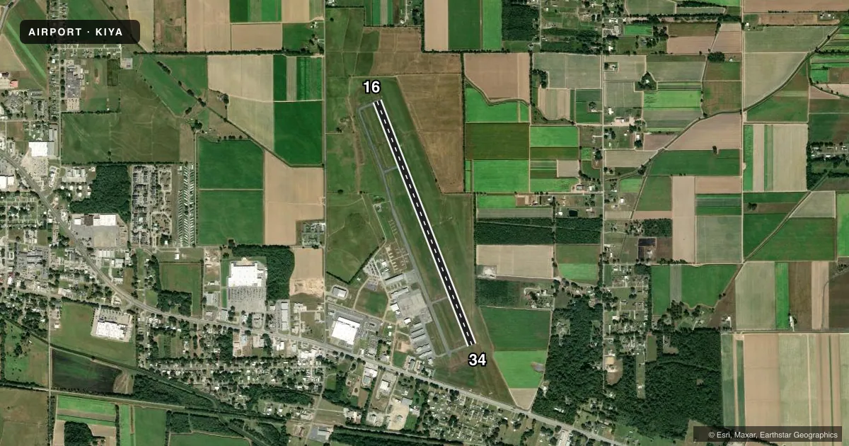
Airport sketch
Runways drawn to scale from FAA survey coordinates, rendered over satellite imagery. Not for navigation.
Approaches & charts
ILS · 1
Services on the field
Fuel grades, oxygen, maintenance, ramp storage and lighting — as declared to the FAA by the airport operator.
Fuel & services
- Fuel
- 100LLA
- Oxygen (bottled)
- Not available
- Oxygen (bulk)
- Not available
- Airframe repair
- Major
- Power plant repair
- Major
- Other services
- AGRI,CHTR,INSTR,SALES
Ramp & ground
- Transient storage
- Tie-down
- Hangar
- Landing fee
- No fee published
- Customs
- Not available
- Lighting schedule
- SEE RMK
- Beacon schedule
- SS-SR
- Beacon
- White / Green (civil land)(WG)
- Wind indicator
- Lighted
- Segmented circle
- No
Fuel & FBOs
Cheapest 100LL and Jet A on the field and nearby. Always confirm with the FBO before taxi.
Airport notes
Surface conditions, obstructions, local procedures, lighting outages and other notes published with each FAA cycle.
General notes
- GCO AVBL ON FREQ 135.075 THRU LAFAYETTE APCH & DE RIDDER FSS.
- FOR CD CTC LAFAYETTE APCH AT 337-262-2729, WHEN APCH CLSD CTC HOUSTON ARTCC AT 281-230-5622.
- CTC ARPT MGR FOR DSNGD RAMP SPACE FOR PUB USE AT ARPT
Lighting notes
- DUSK-DAWN. MIRL RY 16/34 & REIL RYS 16 & 34 PRESET LOW INTST DUSK-DAWN; TO INCR INTST ACTVT - CTAF.
Other notes
- THIS AIRPORT HAS BEEN SURVEYED BY THE NATIONAL GEODETIC SURVEY.
- TPA 336 FT AGL ULTRLIGHT WI 3 MILES OF ARPT.
VFR map & nearby airports
VFR sectional. Tap any ICAO chip to open that airport.
Key facts · KIYA
Answer card- ICAO
- KIYA
- Name
- ABBEVILLE CHRIS CRUSTA MEML
- Location
- ABBEVILLE, LOUISIANA
- Elevation
- 15.9 ft MSL
- Traffic pattern altitude
- 351.9 ft MSL (336 AGL)
- Control tower
- Non-towered (use CTAF)
- Total runways
- 1
- Longest runway
- 16/34 · 5,000 ft
- Published ILS approaches
- 1
- Published frequencies
- 4
- Magnetic variation
- 2°
- Current flight rules
- VFR
- Current wind
- 220° at 4 kt
- Favored runway now
- RWY 16
Abbeville Chris Crusta Meml sits in Abbeville, Louisiana. The field elevation is 15.9 ft MSL. It has one runway, 16/34, which is 5,000 ft long and asphalt. The airport is not towered. Pattern altitude is 336 ft AGL, which is 351.9 ft MSL. The runway has one ILS approach on runway 16.
Vector Aviation is on the field. It carries AVGAS 100LL and Jet A Prist. If you need clearance delivery, contact Lafayette Approach. When approach is closed, use Houston ARTCC. The airport also has a ground communications outlet on 135.075 through Lafayette Approach and De Ridder Flight Service Station.
For a first-time arrival, pay attention to the low field elevation and the fact that this is a non-towered airport with published pattern altitude for ultralights within 3 miles of the airport. From dusk to dawn, medium intensity runway lights are on runway 16/34. The runway end identifier lights on 16 and 34 start at low intensity. You can increase intensity by activating the CTAF. Contact the airport manager if you need designated ramp space for public use. Check the current FAA Chart Supplement for any current operational notes before you go.