METAR & TAF 2R1
2R1 does not publish a METAR.
Showing the nearest reporting station: KARA (ACADIANA RGNL) · 14.1 NM away. Conditions at 2R1 may differ.
METAR · KARA
Observed 04:53Z
KARA 270453Z AUTO 24003KT 10SM CLR 26/24 A3001 RMK AO2 SLP161 T02610244
- Wind
- 240° @ 3 kt
- Visibility
- 10 SM
- Temp / Dew
- 26°C / 24°C
- Altimeter
- 30.01 inHg
- Clouds
- CLR
- Density alt
- 1,226 ft
- Ceiling
- Unlimited
- Rules
- VFR
Airport info & contacts
Manager on record, flight service, ARTCC, attendance schedule and pattern altitude — published by the FAA and refreshed every 28 days.
Location
- From city
- 1 NM S
- VFR sectional
- HOUSTON
- ARTCC
- ZHU · HOUSTON
- NOTAM facility
- DRI (NOTAM-D)
Airport manager
- Name
- MAURICE SONGY
- Phone
- 337-365-7202
- Address
- 1404 HANGAR DR., NEW IBERIA LA 70560
Flight service · Hours
- FSS DRI
- DE RIDDER1-800-WX-BRIEF
- Attendance
- Unattended
Frequencies
Tap any row to copy the frequency to your clipboard.
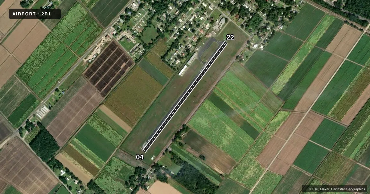
Runways & pattern
Full pagePattern entry · RWY 22
LEFT TRAFFICRunway end performance
| End | TORA | TODA | ASDA | LDA | VGSI | Approach lights | Obstruction |
|---|---|---|---|---|---|---|---|
| 04 | — | — | — | — | PAPI 2-box left(4.5°) | — | 21', trees, 352' from thr, 0' R of cntrln, slope 7 |
| 22 | — | — | — | — | PAPI 2-box left(3.75°) | — | 68', trees, 607' from thr, 109' R of cntrln, slope 5 |
Declared distances in feet. TORA = takeoff run available, TODA = takeoff distance, ASDA = accelerate-stop, LDA = landing distance.
Airport sketch
Runways drawn to scale from FAA survey coordinates, rendered over satellite imagery. Not for navigation.
Approaches & charts
Services on the field
Fuel grades, oxygen, maintenance, ramp storage and lighting — as declared to the FAA by the airport operator.
Fuel & services
- Fuel
- 100LL
- Oxygen (bottled)
- Not available
- Oxygen (bulk)
- Not available
- Airframe repair
- Not available
- Power plant repair
- Not available
- Other services
- AGRI
Ramp & ground
- Transient storage
- Tie-down
- Hangar
- Landing fee
- No fee published
- Customs
- Not available
- Lighting schedule
- SEE RMK
- Beacon schedule
- SS-SR
- Beacon
- White / Green (civil land)(WG)
- Wind indicator
- Lighted
- Segmented circle
- No
Fuel & FBOs
Cheapest 100LL and Jet A on the field and nearby. Always confirm with the FBO before taxi.
Airport notes
Surface conditions, obstructions, local procedures, lighting outages and other notes published with each FAA cycle.
General notes
- FOR CD CTC LAFAYETTE APCH AT 337-262-2729, WHEN APCH CLSD CTC HOUSTON ARTCC AT 281-230-5622.
- CTC APRT MGR FOR DSGND RAMP SPACE FOR PUB USE.
Lighting notes
- SS-SR. MIRL RY 04/22 & REIL RYS 04 & 22 PRESET LOW INTST SS-SR; TO INCR INTST ACTVT -122.90.
Fuel notes
- 100LLFUEL AVBL 24 HRS SELF SERVICE WITH CREDIT CARD.
Approach & departure obstructions
- 22APCH SLOPE 17:1 TO DSPLCD THLD.
Other notes
- 2FOR ARPT ATTENDANT CALL 337-365-7202.
- 04/22PAVEMENT ROUGHNESS, MDT TO SEV LONGITUDINAL CRACKING, RAVELING PRODUCING FOD APPROXIMATELY 1000 FT FM EOR 22.
VFR map & nearby airports
VFR sectional. Tap any ICAO chip to open that airport.
Key facts · 2R1
Answer card- ICAO
- 2R1
- Name
- LE MAIRE MEML
- Location
- JEANERETTE, LOUISIANA
- Elevation
- 14 ft MSL
- Traffic pattern altitude
- 1,014 ft MSL (1,000 AGL)
- Control tower
- Non-towered (use CTAF)
- Total runways
- 1
- Longest runway
- 04/22 · 3,000 ft
- Published ILS approaches
- 0
- Published frequencies
- 1
- Magnetic variation
- 4°
- Current flight rules
- VFR
- Current wind
- 240° at 3 kt
- Favored runway now
- RWY 22
Le Maire Memorial Airport sits in Jeanerette, Louisiana. Field elevation is 14 ft MSL. The airport has one runway. Runway 04/22 is 3,000 ft asphalt, which is the longest runway on the field. There is no control tower. CTAF is 122.9.
No ILS approaches are published here. Pattern altitude is not published, so use standard 1,000 ft AGL unless the current Chart Supplement says otherwise. The field has one on-field FBO, Le Maire Memorial Airport. It carries AVGAS 100LL. Fuel is available 24 hours self service with credit card.
A few remarks matter before you go. Runway lights are medium intensity from sunset to sunrise. REILs are on both ends of 04/22. Use 122.90 to increase light intensity. The approach to runway 22 has a 17 to 1 slope to the displaced threshold. There is also reported pavement roughness with moderate to severe longitudinal cracking and raveling near the last 1,000 ft from the end of runway 22. For clearance delivery, contact Lafayette Approach. If approach is closed, contact Houston ARTCC. If you need ramp space for public use, call the airport manager first.