METAR & TAF KARA
Current METAR
Observed 07:53Z
KARA 270753Z AUTO 00000KT 10SM CLR 24/24 A2998 RMK AO2 SLP150 T02440239 $
- Wind
- 000° @ 0 kt
- Visibility
- 10 SM
- Temp / Dew
- 24°C / 24°C
- Altimeter
- 29.98 inHg
- Clouds
- CLR
- Density alt
- 1,035 ft
- Ceiling
- Unlimited
- Rules
- VFR
Airport info & contacts
Manager on record, flight service, ARTCC, attendance schedule and pattern altitude — published by the FAA and refreshed every 28 days.
Location
- From city
- 4 NM NW
- VFR sectional
- HOUSTON
- ARTCC
- ZHU · HOUSTON
- NOTAM facility
- ARA (NOTAM-D)
Airport manager
- Name
- MAURICE SONGY
- Phone
- (337) 365-7202
- Address
- 1404 HANGAR DR, NEW IBERIA LA 70560
Flight service · Hours
- FSS DRI
- DE RIDDER1-800-WX-BRIEF
- Attendance
- 0700-2100
Frequencies
Tap any row to copy the frequency to your clipboard.
Runways & pattern
Full pagePattern entry · RWY 17
LEFT TRAFFIC| Runway | Heading (°M) | Length | Surface | Traffic |
|---|---|---|---|---|
| 17/35 | 168° / 348° | 8,002 ft | CONC | 35 R |
| 17W/35W | 168° / 348° | 5,000 ft | WATER | 17W R |
Runway end performance
| End | TORA | TODA | ASDA | LDA | VGSI | Approach lights | Obstruction |
|---|---|---|---|---|---|---|---|
| 17 | 8,002' | 8,002' | 8,002' | 8,002' | PAPI 4-box left(3°) | ODALS | — |
| 35 | 8,002' | 8,002' | 8,002' | 8,002' | PAPI 4-box left(3°) | MALSR | — |
| 17W | 5,000' | 5,000' | 5,000' | 5,000' | — | — | — |
| 35W | 5,000' | 5,000' | 5,000' | 5,000' | — | — | — |
Declared distances in feet. TORA = takeoff run available, TODA = takeoff distance, ASDA = accelerate-stop, LDA = landing distance.
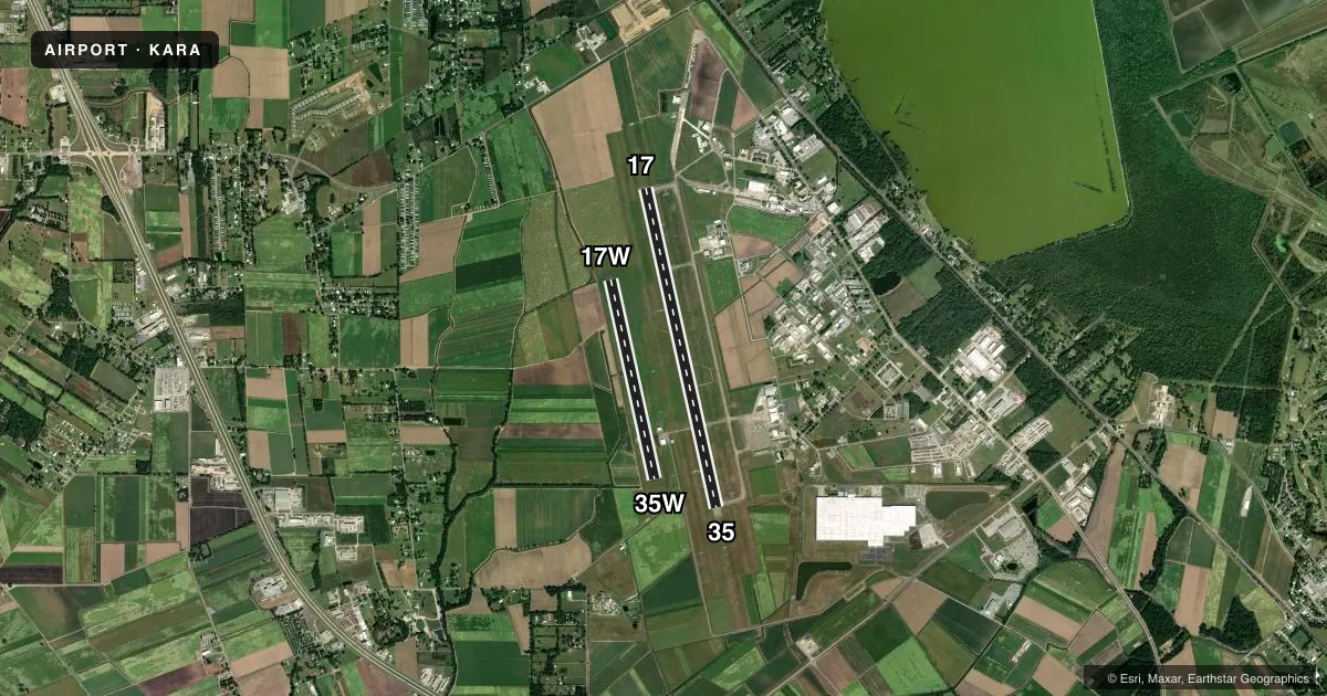
Airport sketch
Runways drawn to scale from FAA survey coordinates, rendered over satellite imagery. Not for navigation.
Approaches & charts
ILS · 1
Services on the field
Fuel grades, oxygen, maintenance, ramp storage and lighting — as declared to the FAA by the airport operator.
Fuel & services
- Fuel
- 100LLA
- Oxygen (bottled)
- Low pressure
- Oxygen (bulk)
- Not available
- Airframe repair
- Minor
- Power plant repair
- Minor
- Other services
- AFRT,CARGO,INSTR
Ramp & ground
- Transient storage
- Tie-down
- Hangar
- Landing fee
- No fee published
- Customs
- Not available
- Lighting schedule
- SEE RMK
- Beacon schedule
- SS-SR
- Beacon
- White / Green (civil land)(WG)
- Wind indicator
- Lighted
- Segmented circle
- Yes
Fuel & FBOs
Cheapest 100LL and Jet A on the field and nearby. Always confirm with the FBO before taxi.
Airport notes
Surface conditions, obstructions, local procedures, lighting outages and other notes published with each FAA cycle.
General notes
- ROTOR WING MOVEMENT AND LANDING AREA BETWEEN THE RY AND SEAWAY.
- INTENSIVE HELO TRAINING.
- SEAPLANE LNDG AREA (WATER CHANNEL) NOT AVBL / PERM CLSD
- BIRD ACTIVITY ON & INVOF ARPT.
- COMPASS ROSE NOT AVBL.
- FOR CD WHEN APCH CLSD CTC HOUSTON ARTCC AT 281-230-5622.
- ARFF INDEX B BTN 1200Z AND 0830Z MON THRU FRI. ANY ADDITIONAL REQUIRES 24 PPR.
- NO OVERNIGHT CAMPING.
- CTC APRT MGR FOR DSGND RAMP SPACE FOR PUB USE.
Lighting notes
- DUSK-DAWN. WHEN ATCT CLSD HIRL RY 17/35 PRESET LOW INTST; TO INCR INTST & ACTVT MALSR RY 35 - CTAF.
Fuel notes
- 100LLFOR FUEL AFT HRS CALL 337-367-1401 FAX 337-367-1404.
Runway surface & condition
- 17/35PCR VALUE: 500/R/B/W/T
Other notes
- THIS AIRPORT HAS BEEN SURVEYED BY THE NATIONAL GEODETIC SURVEY.
- PPR FOR MORE THAN 30 PSGR SEATS CALL AMGR 337-365-7202 (M-F 0830-1630).
VFR map & nearby airports
VFR sectional. Tap any ICAO chip to open that airport.
Key facts · KARA
Answer card- ICAO
- KARA
- Name
- ACADIANA RGNL
- Location
- NEW IBERIA, LOUISIANA
- Elevation
- 24 ft MSL
- Traffic pattern altitude
- 1,024 ft MSL (1,000 AGL)
- Control tower
- Towered · 0600-2100
- Total runways
- 2
- Longest runway
- 17/35 · 8,002 ft
- Published ILS approaches
- 1
- Published frequencies
- 10
- Magnetic variation
- 0°
- Current flight rules
- VFR
- Current wind
- 000° at 0 kt
- Favored runway now
- –
Acadiana Rgnl sits in New Iberia, Louisiana. The field elevation is 24 ft MSL. It has 2 runways. The longest is runway 17/35 at 8,002 ft. There is also a 5,000 ft water runway, 17W/35W, though the seaplane landing area in the water channel is permanently closed. The tower is open from 0600 to 2100. One ILS approach is published for runway 35.
Pattern altitude is not published. Use the standard 1,000 ft AGL for light piston traffic unless the current FAA Chart Supplement says otherwise. The airport has magnetic variation of 0°. Runway headings are 168° and 348° magnetic.
Freeman Jet Center - Acadiana is on the field. It carries 100LL, Jet A and Jet A Prist. Lighting is dusk to dawn. When the tower is closed, the high intensity runway lights on 17/35 come up preset to low intensity. Use CTAF to raise intensity and to activate the medium intensity approach lighting system with runway alignment indicator lights for runway 35. Expect helicopter activity. Rotor wing movement and landing area is between the runway and seawall. Bird activity is also reported on and near the airport. If you need ramp space for public use or special operating permission, contact the airport manager directly.