METAR & TAF KOPL
Current METAR
Observed 06:15Z
KOPL 270615Z AUTO 00000KT 10SM CLR 26/25 A2999 RMK AO2 T02610247
- Wind
- 000° @ 0 kt
- Visibility
- 10 SM
- Temp / Dew
- 26°C / 25°C
- Altimeter
- 29.99 inHg
- Clouds
- CLR
- Density alt
- 1,325 ft
- Ceiling
- Unlimited
- Rules
- VFR
Airport info & contacts
Manager on record, flight service, ARTCC, attendance schedule and pattern altitude — published by the FAA and refreshed every 28 days.
Location
- From city
- 2 NM NW
- VFR sectional
- HOUSTON
- ARTCC
- ZHU · HOUSTON
- NOTAM facility
- OPL (NOTAM-D)
Airport manager
- Name
- LLOYD ARDOIN
- Phone
- 337-407-1551
- Address
- 299 HANGAR RD., OPELOUSAS LA 70570
Flight service · Hours
- FSS DRI
- DE RIDDER1-800-WX-BRIEF
- Attendance
- MON-FRI · 0800-1630
- SAT · 0800-1200
Frequencies
Tap any row to copy the frequency to your clipboard.
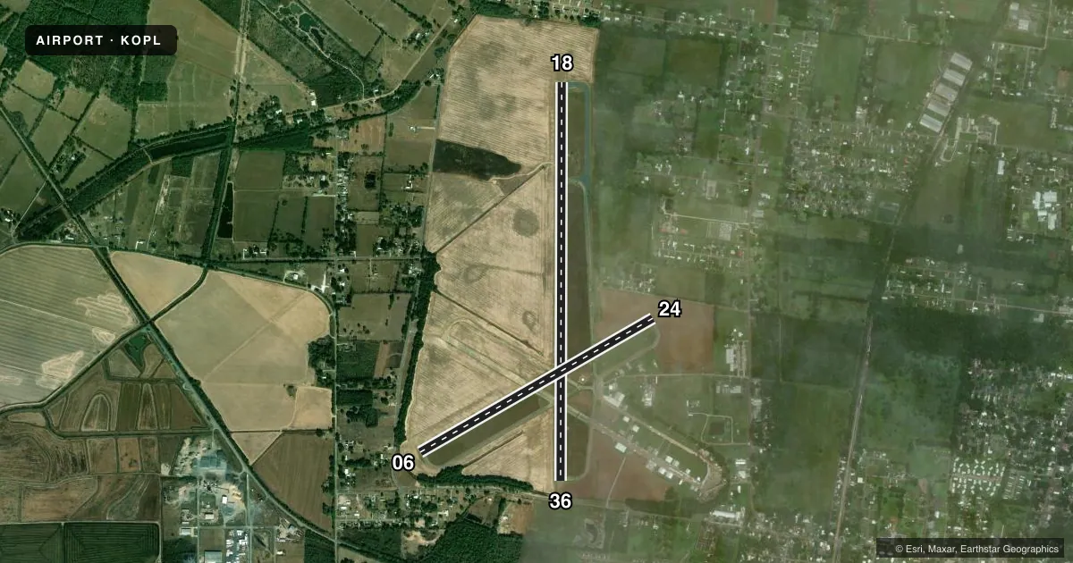
Runways & pattern
Full pagePattern entry · RWY 18
RIGHT TRAFFIC| Runway | Heading (°M) | Length | Surface | Traffic |
|---|---|---|---|---|
| 18/36 | 179° / 359° | 5,999 ft | CONC | 18 R |
| 06/24 | 59° / 239° | 4,051 ft | CONC | 24 R |
Runway end performance
| End | TORA | TODA | ASDA | LDA | VGSI | Approach lights | Obstruction |
|---|---|---|---|---|---|---|---|
| 18 | — | — | — | — | PAPI 2-box left(3.5°) | — | 48', tree, 943' from thr, 114' R of cntrln, slope 15 |
| 36 | — | — | — | — | PAPI 2-box left(3.5°) | — | 19', road, 307' from thr, 0' R of cntrln, slope 5 |
| 06 | — | — | — | — | — | — | 46', trees, 520' from thr, 110' R of cntrln, slope 6 |
| 24 | — | — | — | — | — | — | 56', trees, 941' from thr, 16' R of cntrln, slope 13 |
Declared distances in feet. TORA = takeoff run available, TODA = takeoff distance, ASDA = accelerate-stop, LDA = landing distance.
Airport sketch
Runways drawn to scale from FAA survey coordinates, rendered over satellite imagery. Not for navigation.
Approaches & charts
Services on the field
Fuel grades, oxygen, maintenance, ramp storage and lighting — as declared to the FAA by the airport operator.
Fuel & services
- Fuel
- 100LLA+
- Airframe repair
- Minor
- Power plant repair
- Minor
- Other services
- AGRI
Ramp & ground
- Transient storage
- Tie-down
- Hangar
- Landing fee
- No fee published
- Customs
- Not available
- Lighting schedule
- SEE RMK
- Beacon schedule
- SS-SR
- Beacon
- White / Green (civil land)(WG)
- Wind indicator
- Lighted
- Segmented circle
- Yes
Fuel & FBOs
Cheapest 100LL and Jet A on the field and nearby. Always confirm with the FBO before taxi.
Airport notes
Surface conditions, obstructions, local procedures, lighting outages and other notes published with each FAA cycle.
General notes
- FOR CD CTC LAFAYETTE APCH AT 337-262-2729, WHEN APCH CLSD CTC HOUSTON ARTCC AT 281-230-5622.
- CTC APRT MGR FOR DSGND RAMP SPACE FOR PUB USE.
Lighting notes
- REIL RWY 18 & 36; MIRL RWY 18/36, PRESET LOW INTST DUSK-DAWN; TO INCR INTST ACTVT - CTAF.
Fuel notes
- 100LLCTC ARPT MGR FOR ACCEPTABLE FORMS OF PAYMENT FOR FUEL.
Approach & departure obstructions
- 06RWY MARKINGS ARE FADED.
- 24RWY MARKINGS ARE FADED.
- 06APCH RATIO 10:1 FM DSPLCD THLD.
- 18APCH SLOPE 16:1 TO DSPLCD THLD.
- 24APCH RATIO 16:1 FM DSPLCD THLD.
- 36APCH SLOPE 30:1 TO DSPLCD THLD.
Other notes
- MANAGERAFTER HRS EMERG CELL 337-351-0025.
- 06/24RWY HAS SOME CRACKS WITH GRASS GROWING THRU CRACKS.
VFR map & nearby airports
VFR sectional. Tap any ICAO chip to open that airport.
Key facts · KOPL
Answer card- ICAO
- KOPL
- Name
- ST LANDRY PARISH
- Location
- OPELOUSAS, LOUISIANA
- Elevation
- 74.3 ft MSL
- Traffic pattern altitude
- 1,074.3 ft MSL (1,000 AGL)
- Control tower
- Non-towered (use CTAF)
- Total runways
- 2
- Longest runway
- 18/36 · 5,999 ft
- Published ILS approaches
- 0
- Published frequencies
- 4
- Magnetic variation
- 1°
- Current flight rules
- VFR
- Current wind
- 000° at 0 kt
- Favored runway now
- –
St Landry Parish Airport (KOPL) sits in Opelousas, Louisiana. Field elevation is 74.3 ft MSL. The airport has two concrete runways. Runway 18/36 is the longest at 5,999 ft. Runway 06/24 is 4,051 ft. There is no control tower, so expect self-announce traffic on CTAF 123.0 or UNICOM 123.0.
No ILS approaches are published here. Pattern altitude is not published, so use the standard 1,000 ft AGL for light piston operations unless the current Chart Supplement says otherwise. The field has published approach and departure service with Lafayette on 128.7 and 268.7, which is useful when you need IFR help or clearance delivery. Published remarks also note that runway 06/24 has cracks with grass growing through them. Markings on runways 06 and 24 are faded. Runway end identifier lights are installed on 18 and 36. Medium intensity lights are installed on 18 and 36. They default to low intensity from dusk to dawn. Use the CTAF to increase intensity.
The on-field FBO is St. Landry Parish Airport. It carries 100LL and Jet A Prist. Contact the airport manager for ramp space and acceptable payment forms for 100LL. The airport manager can also be reached after hours for emergencies. For a first visit, plan for a non-towered field with concrete pavement issues on 06/24 and displaced-threshold obstacle considerations on all four runway ends.