METAR & TAF 2R6
2R6 does not publish a METAR.
Showing the nearest reporting station: KMKV (MARKSVILLE MUNI) · 11.9 NM away. Conditions at 2R6 may differ.
METAR · KMKV
Observed 10:35Z
KMKV 271035Z AUTO 00000KT 9SM CLR 25/25 A2998 RMK AO2 T02510248
- Wind
- 000° @ 0 kt
- Visibility
- 9 SM
- Temp / Dew
- 25°C / 25°C
- Altimeter
- 29.98 inHg
- Clouds
- CLR
- Density alt
- 1,202 ft
- Ceiling
- Unlimited
- Rules
- VFR
Airport info & contacts
Manager on record, flight service, ARTCC, attendance schedule and pattern altitude — published by the FAA and refreshed every 28 days.
Location
- From city
- 2 NM S
- VFR sectional
- HOUSTON
- ARTCC
- ZHU · HOUSTON
- NOTAM facility
- DRI (NOTAM-D)
Airport manager
- Name
- LUKE KOJIS
- Phone
- 318-359-0716
- Address
- 110 EVERGREEN ST, BUNKIE LA 71322-1304
Flight service · Hours
- FSS DRI
- DE RIDDER1-800-WX-BRIEF
- Attendance
- Unattended
Frequencies
Tap any row to copy the frequency to your clipboard.
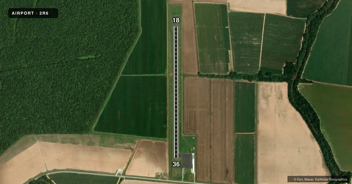
Runways & pattern
Full pagePattern entry · RWY 18
LEFT TRAFFICRunway end performance
| End | TORA | TODA | ASDA | LDA | VGSI | Approach lights | Obstruction |
|---|---|---|---|---|---|---|---|
| 18 | — | — | — | — | PAPI 2-box left(3°) | — | — |
| 36 | — | — | — | — | PAPI 2-box left(3.25°) | — | 97', trees, 2752' from thr, 397' R of cntrln, slope 26 |
Declared distances in feet. TORA = takeoff run available, TODA = takeoff distance, ASDA = accelerate-stop, LDA = landing distance.
Airport sketch
Runways drawn to scale from FAA survey coordinates, rendered over satellite imagery. Not for navigation.
Approaches & charts
Services on the field
Fuel grades, oxygen, maintenance, ramp storage and lighting — as declared to the FAA by the airport operator.
Fuel & services
- Fuel
- 100LL
- Oxygen (bottled)
- Not available
- Oxygen (bulk)
- Not available
- Airframe repair
- Not available
- Power plant repair
- Not available
- Other services
- AGRI,INSTR
Ramp & ground
- Transient storage
- Tie-down
- Hangar
- Landing fee
- No fee published
- Customs
- Not available
- Lighting schedule
- SEE RMK
- Beacon schedule
- SS-SR
- Beacon
- White / Green (civil land)(WG)
- Wind indicator
- Lighted
- Segmented circle
- No
Fuel & FBOs
Cheapest 100LL and Jet A on the field and nearby. Always confirm with the FBO before taxi.
Airport notes
Surface conditions, obstructions, local procedures, lighting outages and other notes published with each FAA cycle.
General notes
- 100LL FUEL AVBL BY APPT CALL 318-359-0716.
- FOR CD CTC MAKS APCH AT 726-780-0456.
- CTC APRT MGR FOR DSGND RAMP SPACE FOR PUB USE.
Lighting notes
- ACTVT REIL RWY 18 & 36; MIRL RWY 18/36 - CTAF. MIRL RWY 18/36 PRESET LOW INTST DUSK-DAWN; INCR INTST - CTAF.
Other notes
- THIS AIRPORT HAS BEEN SURVEYED BY THE NATIONAL GEODETIC SURVEY.
- ARPT PREDATES THE ACT.
VFR map & nearby airports
VFR sectional. Tap any ICAO chip to open that airport.
Key facts · 2R6
Answer card- ICAO
- 2R6
- Name
- BUNKIE MUNI
- Location
- BUNKIE, LOUISIANA
- Elevation
- 62 ft MSL
- Traffic pattern altitude
- 1,062 ft MSL (1,000 AGL)
- Control tower
- Non-towered (use CTAF)
- Total runways
- 1
- Longest runway
- 18/36 · 3,005 ft
- Published ILS approaches
- 0
- Published frequencies
- 3
- Magnetic variation
- 1°
- Current flight rules
- VFR
- Current wind
- 000° at 0 kt
- Favored runway now
- –
Bunkie Muni (2R6) sits in Bunkie, Louisiana. Field elevation is 62 ft MSL. The airport has one runway. Runway 18/36 is 3,005 ft of asphalt, so plan performance with that length in mind. There is no control tower. The pattern altitude is not published, so use the standard 1,000 ft AGL for light piston traffic unless the current Chart Supplement says otherwise.
No ILS approaches are published here. For clearance delivery, contact MAKS Approach at 726-780-0456. CTAF is 122.9. The published remarks also note that runway end identifier lights are installed on 18 and 36. Medium intensity runway lights are controlled by CTAF. They are preset to low intensity from dusk to dawn, then increase when CTAF is used.
There are no on-field FBOs listed. 100LL is available by appointment. Call 318-359-0716 before you go. Contact the airport manager for designated ramp space for public use. If you are planning a first visit, treat this as a small non-towered field with limited published services. Check the current FAA Chart Supplement for any changes before departure.