METAR & TAF KESF
Current METAR
Observed 02:53Z
KESF 270253Z AUTO 00000KT 10SM CLR 26/25 A2995 RMK AO2 SLP141 T02610250 53004
- Wind
- 000° @ 0 kt
- Visibility
- 10 SM
- Temp / Dew
- 26°C / 25°C
- Altimeter
- 29.95 inHg
- Clouds
- CLR
- Density alt
- 1,421 ft
- Ceiling
- Unlimited
- Rules
- VFR
Airport info & contacts
Manager on record, flight service, ARTCC, attendance schedule and pattern altitude — published by the FAA and refreshed every 28 days.
Location
- From city
- 10 NM NE
- VFR sectional
- HOUSTON
- ARTCC
- ZHU · HOUSTON
- NOTAM facility
- ESF (NOTAM-D)
Airport manager
- Name
- LOUIS BUSBY
- Phone
- 985-750-0485
- Address
- 7625 ESLER FIELD RD, PINEVILLE LA 71360
Flight service · Hours
- FSS DRI
- DE RIDDER1-800-WX-BRIEF
- Attendance
- TUE-FRI · 0700-1730
Frequencies
Tap any row to copy the frequency to your clipboard.
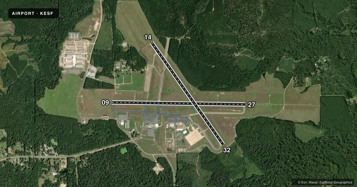
Runways & pattern
Full pagePattern entry · RWY 09
LEFT TRAFFIC| Runway | Heading (°M) | Length | Surface | Traffic |
|---|---|---|---|---|
| 09/27 | 90° / 270° | 5,998 ft | ASPH | Standard L |
| 14/32 | 144° / 324° | 5,600 ft | ASPH | Standard L |
Runway end performance
| End | TORA | TODA | ASDA | LDA | VGSI | Approach lights | Obstruction |
|---|---|---|---|---|---|---|---|
| 09 | — | — | — | — | PAPI 4-box left(3°) | — | 82', trees, 3080' from thr, slope 35 |
| 27 | — | — | — | — | — | MALSR | — |
| 14 | — | — | — | — | PAPI 4-box left(3°) | — | 116', trees, 2056' from thr, 1324' R of cntrln, slope 16 |
| 32 | — | — | — | — | PAPI 4-box left(3°) | — | 5', fence, 185' from thr, 0' R of cntrln, slope 0 |
Declared distances in feet. TORA = takeoff run available, TODA = takeoff distance, ASDA = accelerate-stop, LDA = landing distance.
Airport sketch
Runways drawn to scale from FAA survey coordinates, rendered over satellite imagery. Not for navigation.
Approaches & charts
ILS · 1
Services on the field
Fuel grades, oxygen, maintenance, ramp storage and lighting — as declared to the FAA by the airport operator.
Fuel & services
- Fuel
- 100LLA
Ramp & ground
- Transient storage
- Tie-down
- Landing fee
- No fee published
- Customs
- Not available
- Lighting schedule
- SEE RMK
- Beacon schedule
- SS-SR
- Beacon
- White / Green (civil land)(WG)
- Wind indicator
- Lighted
- Segmented circle
- Yes
Fuel & FBOs
Cheapest 100LL and Jet A on the field and nearby. Always confirm with the FBO before taxi.
Airport notes
Surface conditions, obstructions, local procedures, lighting outages and other notes published with each FAA cycle.
General notes
- BIRDS ON & INVOF ARPT SEASONALLY.
- PAEW ADJ RWYS & TWYS.
- FOR CD CTC MAKS APCH AT 726-780-0456.
- CTC APRT MGR FOR DSGND RAMP SPACE FOR PUB USE.
Lighting notes
- ACTVT MALSR RWY 27; REIL RWY 09, 14/32; MIRL RWY 14/32; HIRL RWY 9/27; TWY LGTS TWYS A, B, C, D & E - CTAF.
Fuel notes
- 100LLFUEL AVBL TUE-FRI 0700-1700; SAT-MON ON CALL IN ADVANCE CALL 318-443-5566. 100LL SELF SERVE 24HRS
Approach & departure obstructions
- 32FENCE 100 FT 0B AND SMALL TREE 14 FT TALL 232 FT FM END OF RY.
- 09RWY 09 REILS OTS
- 14RWY 14 REIL OTS
- 14RWY MARKINGS SEVERELY FADED
- 32RWY MARKINGS SEVERELY FADED
- 14RWY 14 PAPI OTS
Other notes
- PL 85-204/SPECIAL ACT OF CONGRESS
VFR map & nearby airports
VFR sectional. Tap any ICAO chip to open that airport.
Key facts · KESF
Answer card- ICAO
- KESF
- Name
- ESLER RGNL
- Location
- ALEXANDRIA, LOUISIANA
- Elevation
- 111.8 ft MSL
- Traffic pattern altitude
- 1,111.8 ft MSL (1,000 AGL)
- Control tower
- Non-towered (use CTAF)
- Total runways
- 2
- Longest runway
- 09/27 · 5,998 ft
- Published ILS approaches
- 1
- Published frequencies
- 4
- Magnetic variation
- 1°
- Current flight rules
- VFR
- Current wind
- 000° at 0 kt
- Favored runway now
- –
Esler Regional Airport sits in Alexandria, Louisiana. Field elevation is 111.8 ft MSL. The airport has two asphalt runways. The longest is runway 09/27 at 5,998 ft. It is an untowered field, so expect self-announce traffic on CTAF 122.8. The published ILS is for runway 27. Pattern altitude is not published. Use standard 1,000 ft AGL for light piston operations unless the current Chart Supplement says otherwise.
Freeman Jet Center is on the field. It carries 100LL and Jet A. 100LL self-serve is available 24 hours. Published remarks also note that fuel is available Tuesday through Friday from 0700 to 1700. On Saturday through Monday, fuel is available on call in advance. The airport has runway and taxiway lighting that is pilot-controlled on CTAF. MALSR is active on runway 27. REILs are available on runway 09 and on runway 14/32, though the REILs on 09 and 14 are out of service per the remarks. Runway 14 markings are severely faded. Runway 32 markings are also severely faded.
For a first-time arrival, pay attention to the seasonal bird activity and the obstruction note near runway 32. The airport also has paved areas adjacent to runways and taxiways. If you need ramp space for public use, contact the airport manager before arrival. Clearance delivery is handled through MAKS Approach. Check the current FAA Chart Supplement for any changes before you go.