METAR & TAF 2L0
2L0 does not publish a METAR.
Showing the nearest reporting station: KAEX (ALEXANDRIA INTL) · 5.5 NM away. Conditions at 2L0 may differ.
METAR · KAEX
Observed 03:53Z
KAEX 270353Z 21003KT 10SM CLR 28/23 A2997 RMK AO2 SLP152 T02780233
- Wind
- 210° @ 3 kt
- Visibility
- 10 SM
- Temp / Dew
- 28°C / 23°C
- Altimeter
- 29.97 inHg
- Clouds
- CLR
- Density alt
- 1,622 ft
- Ceiling
- Unlimited
- Rules
- VFR
Airport info & contacts
Manager on record, flight service, ARTCC, attendance schedule and pattern altitude — published by the FAA and refreshed every 28 days.
Location
- From city
- 2 NM N
- VFR sectional
- HOUSTON
- ARTCC
- ZHU · HOUSTON
- NOTAM facility
- DRI (NOTAM-D)
Airport manager
- Name
- LONNIE LUCIUS
- Phone
- 318-449-5679
- Address
- 200 LAKE BUHLOW RD, PINEVILLE LA 71360
Flight service · Hours
- FSS DRI
- DE RIDDER1-800-WX-BRIEF
- Attendance
- MON-FRI · 0800-1800
- SAT · 0900-1400
Frequencies
Tap any row to copy the frequency to your clipboard.
Runways & pattern
Full pagePattern entry · RWY 18
LEFT TRAFFICRunway end performance
| End | TORA | TODA | ASDA | LDA | VGSI | Approach lights | Obstruction |
|---|---|---|---|---|---|---|---|
| 18 | — | — | — | — | PAPI 2-box left(4°) | — | 95', trees, 1487' from thr, 197' R of cntrln, slope 13 |
| 36 | — | — | — | — | PAPI 2-box right(3°) | — | 102', trees, 3264' from thr, 170' R of cntrln, slope 30 |
Declared distances in feet. TORA = takeoff run available, TODA = takeoff distance, ASDA = accelerate-stop, LDA = landing distance.
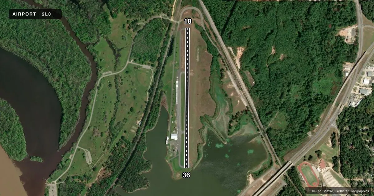
Airport sketch
Runways drawn to scale from FAA survey coordinates, rendered over satellite imagery. Not for navigation.
Approaches & charts
Services on the field
Fuel grades, oxygen, maintenance, ramp storage and lighting — as declared to the FAA by the airport operator.
Fuel & services
- Fuel
- 100LLMOGAS
- Oxygen (bottled)
- Not available
- Oxygen (bulk)
- HIGH/LOW
- Airframe repair
- Major
- Power plant repair
- Major
- Other services
- CHTR,INSTR,RNTL,SURV
Ramp & ground
- Transient storage
- Tie-down
- Hangar
- Landing fee
- No fee published
- Customs
- Not available
- Lighting schedule
- SEE RMK
- Beacon schedule
- SS-SR
- Beacon
- White / Green (civil land)(WG)
- Wind indicator
- Lighted
- Segmented circle
- Yes
Fuel & FBOs
Cheapest 100LL and Jet A on the field and nearby. Always confirm with the FBO before taxi.
Airport notes
Surface conditions, obstructions, local procedures, lighting outages and other notes published with each FAA cycle.
General notes
- RWY 36 LAKE 96 FT FM END OF RWY.
- RWY 18 DROP OFF 95 FT FM END OF RWY.
- ALL RWY 18/36 SAFETY AREAS NONSTANDARD.
- FOR CD CTC MAKS APCH AT 726-780-0456.
- CTC APRT MGR FOR DSGND RAMP SPACE FOR PUB USE.
Lighting notes
- MIRL RWY 18/36; REIL RWY 18/36 PRESET LOW INTST DUSK-DAWN. TO INCR INTST ACTVT - CTAF.
Fuel notes
- 100LLFUEL AVBL 24/7 WITH CC.
Approach & departure obstructions
- 18REILS OUT OF SERVICE APPROACH END RWY 18
- 36REILS OUT OF SERVICE APPROACH END RWY 36
- 18RWY MARKINGS FADED
- 36RWY MARKINGS FADED
Other notes
- WATERWAY ELEV 80 FT.
- TPA 700 FT AGL FOR ACFT FOR WATER RWY 05W/23W, 1000 FT AGL FIXED WING ACFT FOR RWY 18/36.
VFR map & nearby airports
VFR sectional. Tap any ICAO chip to open that airport.
Key facts · 2L0
Answer card- ICAO
- 2L0
- Name
- PINEVILLE MUNI
- Location
- PINEVILLE, LOUISIANA
- Elevation
- 100 ft MSL
- Traffic pattern altitude
- 1,100 ft MSL (1,000 AGL)
- Control tower
- Non-towered (use CTAF)
- Total runways
- 1
- Longest runway
- 18/36 · 3,000 ft
- Published ILS approaches
- 0
- Published frequencies
- 2
- Magnetic variation
- 4°
- Current flight rules
- VFR
- Current wind
- 210° at 3 kt
- Favored runway now
- RWY 18
Pineville Muni sits in Pineville, Louisiana. Field elevation is 100 ft MSL. The airport has one runway. Runway 18/36 is 3,000 ft of asphalt. There is no control tower. CTAF and UNICOM are both 122.8. No ILS approaches are published.
For fixed-wing traffic on runway 18/36, the published pattern altitude is 1,000 ft AGL. That puts the pattern at 1,100 ft MSL. Flightline Air Service is on the field. It carries 100LL. Fuel is available 24 hours a day with a credit card. The runway lights are medium intensity. REIL on both ends are preset low from dusk to dawn. Use CTAF to increase intensity. Runway markings are faded on both ends. REIL is out of service on the approach end of runway 18. REIL is also out of service on the approach end of runway 36.
A few operational items matter here. Runway 36 has a lake 96 ft from the end. Runway 18 has a drop off 95 ft from the end. The runway safety areas are nonstandard. Public ramp space is controlled by the airport manager, so call ahead if you need parking. This is a low-elevation field, but the nearby waterway and the short runway still call for normal short-field discipline. Check the current FAA Chart Supplement before departure for any updates.