METAR & TAF L32
L32 does not publish a METAR.
Showing the nearest reporting station: KESF (ESLER RGNL) · 27.2 NM away. Conditions at L32 may differ.
METAR · KESF
Observed 13:53Z
KESF 261353Z AUTO 27008KT 10SM CLR 28/25 A3007 RMK AO2 SLP179 T02780250
- Wind
- 270° @ 8 kt
- Visibility
- 10 SM
- Temp / Dew
- 28°C / 25°C
- Altimeter
- 30.07 inHg
- Clouds
- CLR
- Density alt
- 1,444 ft
- Ceiling
- Unlimited
- Rules
- VFR
Airport info & contacts
Manager on record, flight service, ARTCC, attendance schedule and pattern altitude — published by the FAA and refreshed every 28 days.
Location
- From city
- 0 NM W
- VFR sectional
- HOUSTON
- ARTCC
- ZHU · HOUSTON
- NOTAM facility
- DRI (NOTAM-D)
Airport manager
- Name
- PAT MC CAUGHEY
- Phone
- 318-339-4747
- Address
- 503 AIRPORT ROAD, PO BOX 116, JONESVILLE LA 71343
Flight service · Hours
- FSS DRI
- DE RIDDER1-800-WX-BRIEF
- Attendance
- MON-FRI · 0800-1700
Frequencies
Tap any row to copy the frequency to your clipboard.
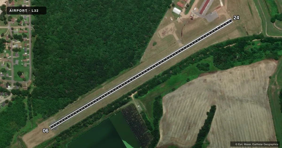
Runways & pattern
Full pagePattern entry · RWY 24
LEFT TRAFFICRunway end performance
| End | TORA | TODA | ASDA | LDA | VGSI | Approach lights | Obstruction |
|---|---|---|---|---|---|---|---|
| 06 | — | — | — | — | PAPI 2-box left(4°) | — | 57', trees, 1237' from thr, 64' R of cntrln, slope 18 |
| 24 | — | — | — | — | PAPI 2-box left(4°) | — | 91', trees, 1326' from thr, 69' R of cntrln, slope 12 |
Declared distances in feet. TORA = takeoff run available, TODA = takeoff distance, ASDA = accelerate-stop, LDA = landing distance.
Airport sketch
Runways drawn to scale from FAA survey coordinates, rendered over satellite imagery. Not for navigation.
Approaches & charts
Services on the field
Fuel grades, oxygen, maintenance, ramp storage and lighting — as declared to the FAA by the airport operator.
Fuel & services
- Fuel
- 100LLA
- Oxygen (bottled)
- Not available
- Oxygen (bulk)
- Not available
- Airframe repair
- Minor
- Power plant repair
- Minor
- Other services
- AGRI
Ramp & ground
- Transient storage
- Tie-down
- Landing fee
- No fee published
- Customs
- Not available
- Lighting schedule
- SEE RMK
- Beacon schedule
- SS-SR
- Beacon
- White / Green (civil land)(WG)
- Wind indicator
- Lighted
- Segmented circle
- Yes
Fuel & FBOs
Cheapest 100LL and Jet A on the field and nearby. Always confirm with the FBO before taxi.
Airport notes
Surface conditions, obstructions, local procedures, lighting outages and other notes published with each FAA cycle.
General notes
- RWY 06/24 TREES BOTH SIDES OF RWY PENETRATE TRANSITION SLOPES.
- FOR CD CTC MAKS APCH AT 726-780-0456.
- CTC APRT MGR FOR DSGND RAMP SPACE FOR PUB USE.
Lighting notes
- DUSK-DAWN. MIRL RY 06/24, REIL RYS 06 & 24 PRESET LOW INTST DUSK-DAWN; TO INCR INTST ACTVT - CTAF.
Fuel notes
- 100LLFOR FUEL AFT HRS CALL 318-339-4747.
Approach & departure obstructions
- 06PAPI OBSTRUCTED BY TREES OTS INDEFLY
- 24PAPI OBSTRUCTED BY TREES OTS INDEFLY.
Other notes
- MANAGEROR 318-339-8298.
VFR map & nearby airports
VFR sectional. Tap any ICAO chip to open that airport.
Key facts · L32
Answer card- ICAO
- L32
- Name
- JONESVILLE
- Location
- JONESVILLE, LOUISIANA
- Elevation
- 56.3 ft MSL
- Traffic pattern altitude
- 1,056.3 ft MSL (1,000 AGL)
- Control tower
- Non-towered (use CTAF)
- Total runways
- 1
- Longest runway
- 06/24 · 2,993 ft
- Published ILS approaches
- 0
- Published frequencies
- 1
- Magnetic variation
- 4°
- Current flight rules
- VFR
- Current wind
- 270° at 8 kt
- Favored runway now
- RWY 24
Jonesville Airport (L32) sits in Jonesville, Louisiana at 56 ft MSL. It has one runway, 06/24, which is 3,000 ft long and paved with asphalt. There is no control tower. CTAF is 122.9. No ILS approaches are published here.
The pattern altitude is not published, so use the standard 1,000 ft AGL unless the current Chart Supplement says otherwise. Trees penetrate the transition slopes on both sides of runway 06/24. That matters on short final and in the climb out. The PAPI on both runway ends is out of service indefinitely because of tree obstruction. Runway lighting is available from dusk to dawn. Medium intensity runway lights are installed. REILs are on both ends and start at low intensity. You can increase intensity by keying the CTAF.
No on-field FBOs are listed in the facts. Fuel after hours is handled by phone through the number in the published remarks. Contact the airport manager for designated ramp space before arrival. For a first visit, plan for a non-towered field with limited published approach support and pay close attention to obstacle clearance on 06 and 24.