METAR & TAF KHEZ
Current METAR
Observed 17:56Z
KHEZ 261756Z AUTO 27006KT 10SM CLR 32/23 A3006 RMK AO2 SLP176 T03220228 10328 20244 58009 $
- Wind
- 270° @ 6 kt
- Visibility
- 10 SM
- Temp / Dew
- 32°C / 23°C
- Altimeter
- 30.06 inHg
- Clouds
- CLR
- Density alt
- 2,204 ft
- Ceiling
- Unlimited
- Rules
- VFR
Airport info & contacts
Manager on record, flight service, ARTCC, attendance schedule and pattern altitude — published by the FAA and refreshed every 28 days.
Location
- From city
- 6 NM NE
- VFR sectional
- HOUSTON
- ARTCC
- ZHU · HOUSTON
- NOTAM facility
- HEZ (NOTAM-D)
Airport manager
- Name
- CARL BEASLEY
- Phone
- 601-597-3033
- Address
- 434 AIRPORT RD, NATCHEZ MS 39120
Flight service · Hours
- FSS GWO
- GREENWOOD1-800-WX-BRIEF
- Attendance
- 0600-2000
Frequencies
Tap any row to copy the frequency to your clipboard.
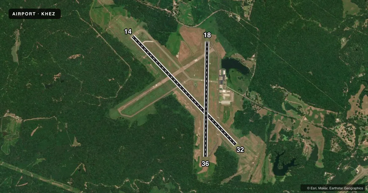
Runways & pattern
Full pagePattern entry · RWY 32
LEFT TRAFFIC| Runway | Heading (°M) | Length | Surface | Traffic |
|---|---|---|---|---|
| 14/32Favored | 136° / 316° | 6,500 ft | ASPH | Standard L |
| 18/36 | 181° / 1° | 5,000 ft | ASPH | Standard L |
Runway end performance
| End | TORA | TODA | ASDA | LDA | VGSI | Approach lights | Obstruction |
|---|---|---|---|---|---|---|---|
| 14 | — | — | — | — | PAPI 4-box right(3°) | MALSR | — |
| 32 | — | — | — | — | PAPI 4-box left(3°) | — | 78', trees, 2400' from thr, 250' R of cntrln, slope 28 |
| 18 | — | — | — | — | VASI 4-box left(3°) | — | — |
| 36 | — | — | — | — | — | — | 63', trees, 1400' from thr, 300' R of cntrln, slope 19 |
Declared distances in feet. TORA = takeoff run available, TODA = takeoff distance, ASDA = accelerate-stop, LDA = landing distance.
Airport sketch
Runways drawn to scale from FAA survey coordinates, rendered over satellite imagery. Not for navigation.
Approaches & charts
ILS · 1
Services on the field
Fuel grades, oxygen, maintenance, ramp storage and lighting — as declared to the FAA by the airport operator.
Fuel & services
- Fuel
- 100LLA
- Oxygen (bottled)
- Not available
- Oxygen (bulk)
- Not available
- Airframe repair
- Minor
- Power plant repair
- Minor
- Other services
- INSTR
Ramp & ground
- Transient storage
- Tie-down
- Hangar
- Landing fee
- No fee published
- Customs
- Not available
- Lighting schedule
- SEE RMK
- Beacon schedule
- SS-SR
- Beacon
- White / Green (civil land)(WG)
- Wind indicator
- Lighted
- Segmented circle
- Yes
Fuel & FBOs
Cheapest 100LL and Jet A on the field and nearby. Always confirm with the FBO before taxi.
Airport notes
Surface conditions, obstructions, local procedures, lighting outages and other notes published with each FAA cycle.
General notes
- GND PWR UNIT AVBL ON FLD.
- DEER ON & INVOF RWYS.
- TWY A & C1 NOT AVBL FOR ACR USE.
Lighting notes
- ACTVT MALSR RWY 14; PAPI RWY 14 & 32; VASI RWY 18; MIRL RWY 18/36 - CTAF.
Runway surface & condition
- 14/32PCR VALUE: 45/F/B/X/T
- 18/36RWY 18/36 NOT AVBL FOR PART 121/PART 380 OPS WITH SKED PAX CARRYING OPS MORE THAN 9 PAX SEATS AND NON-SKED PAX CARRYING OPS MORE THAN 30 PAX SEATS.
Approach & departure obstructions
- 18MARKINGS FADED.
- 36MARKINGS FADED.
Other notes
- CLSD TO UNSKED ACR OPS WITH MORE THAN 30 PAX SEATS EXCP 48 HR PPR CALL AMGR.
- 18/36WIDESPREAD CRACKING & UNEVEN PAVEMENT.
VFR map & nearby airports
VFR sectional. Tap any ICAO chip to open that airport.
Key facts · KHEZ
Answer card- ICAO
- KHEZ
- Name
- HARDY-ANDERS FLD/NATCHEZ-ADAMS COUNTY
- Location
- NATCHEZ, MISSISSIPPI
- Elevation
- 272.4 ft MSL
- Traffic pattern altitude
- 1,272.4 ft MSL (1,000 AGL)
- Control tower
- Non-towered (use CTAF)
- Total runways
- 2
- Longest runway
- 14/32 · 6,500 ft
- Published ILS approaches
- 1
- Published frequencies
- 2
- Magnetic variation
- 0°
- Current flight rules
- VFR
- Current wind
- 270° at 6 kt
- Favored runway now
- RWY 32
Hardy-Anders Fld/Natchez-Adams County sits in Natchez, Mississippi at 272.4 ft MSL. It has two asphalt runways. The longest is 14/32 at 6,500 ft. Runway 18/36 is 5,000 ft. There is no control tower, so expect CTAF and UNICOM on 122.8. The field has one ILS approach to runway 14. Pattern altitude is not published, so use the standard 1,000 ft AGL for light piston traffic unless the current Chart Supplement says otherwise.
Natchez-Adams County Airport is the on-field FBO. It carries 100LL, Jet A and Jet A Prist. Call (601) 442-3142 for current service details. Published remarks matter here. Deer are on and near the runways. Taxiways A and C1 are not available for aircraft use. Runway 18/36 has widespread cracking and uneven pavement. Markings on runway 18 and runway 36 are faded. Runway 14 has MALSR lighting. PAPI is available on runways 14 and 32. VASI is available on runway 18. Medium intensity runway lights are on runways 18 and 36. Use CTAF for lighting activation and traffic calls.
For a first-time arrival, pay attention to the runway condition notes and the wildlife issue. Also note that runway 18/36 is not available for certain larger scheduled and unscheduled passenger operations. If you are planning anything outside normal GA use, check the current FAA Chart Supplement or call the airport operator before departure.