METAR & TAF F89
F89 does not publish a METAR.
Showing the nearest reporting station: KMLU (MONROE RGNL) · 27.5 NM away. Conditions at F89 may differ.
METAR · KMLU
Observed 05:53Z
KMLU 270553Z AUTO 00000KT 10SM CLR 26/23 A2997 RMK AO2 SLP147 T02610233 10350 20261 403670244 50005
- Wind
- 000° @ 0 kt
- Visibility
- 10 SM
- Temp / Dew
- 26°C / 23°C
- Altimeter
- 29.97 inHg
- Clouds
- CLR
- Density alt
- 1,355 ft
- Ceiling
- Unlimited
- Rules
- VFR
Airport info & contacts
Manager on record, flight service, ARTCC, attendance schedule and pattern altitude — published by the FAA and refreshed every 28 days.
Location
- From city
- 1 NM E
- VFR sectional
- MEMPHIS
- ARTCC
- ZFW · FORT WORTH
- NOTAM facility
- DRI (NOTAM-D)
Airport manager
- Name
- TERRY SHIRLEY
- Phone
- (318) 439-3676
- Address
- PO BOX 250, WINNSBORO LA 71295
Flight service · Hours
- FSS DRI
- DE RIDDER1-800-WX-BRIEF
- Attendance
- ON CALL
Frequencies
Tap any row to copy the frequency to your clipboard.
Runways & pattern
Full pagePattern entry · RWY 18
LEFT TRAFFICRunway end performance
| End | TORA | TODA | ASDA | LDA | VGSI | Approach lights | Obstruction |
|---|---|---|---|---|---|---|---|
| 18 | — | — | — | — | PAPI 2-box left(3.75°) | — | 81', tree, 1313' from thr, 230' R of cntrln, slope 13 |
| 36 | — | — | — | — | PAPI 2-box left(3.1°) | — | 45', trees, 839' from thr, 158' R of cntrln, slope 14 |
Declared distances in feet. TORA = takeoff run available, TODA = takeoff distance, ASDA = accelerate-stop, LDA = landing distance.
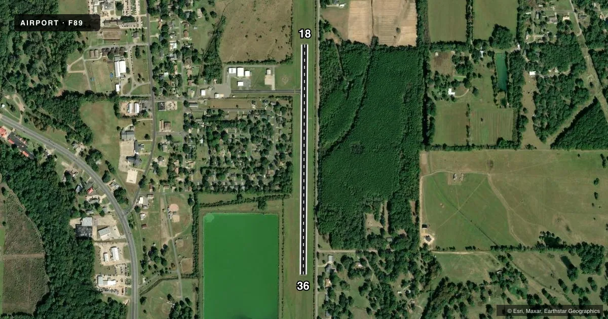
Airport sketch
Runways drawn to scale from FAA survey coordinates, rendered over satellite imagery. Not for navigation.
Approaches & charts
Services on the field
Fuel grades, oxygen, maintenance, ramp storage and lighting — as declared to the FAA by the airport operator.
Fuel & services
- Fuel
- 100LL
- Oxygen (bottled)
- Not available
- Oxygen (bulk)
- Not available
- Airframe repair
- Minor
- Power plant repair
- Minor
- Other services
- AGRI
Ramp & ground
- Transient storage
- Tie-down
- Landing fee
- No fee published
- Customs
- Not available
- Lighting schedule
- SEE RMK
- Beacon schedule
- SS-SR
- Beacon
- White / Green (civil land)(WG)
- Wind indicator
- Lighted
- Segmented circle
- Yes
Fuel & FBOs
Cheapest 100LL and Jet A on the field and nearby. Always confirm with the FBO before taxi.
Airport notes
Surface conditions, obstructions, local procedures, lighting outages and other notes published with each FAA cycle.
General notes
- <HEAVY AGRI ACFT OPS JUNE THRU OCT.
- RWY 18/36 TREES WEST OF RWY OBST VIEW OF OPERATING ACFT.
- FOR CD CTC MONROE APCH AT 318-327-5641, IF UNAVBL, CTC FORT WORTH ARTCC AT 817-858-7584.
- CTC APRT MGR FOR DSGND RAMP SPACE FOR PUB USE.
Lighting notes
- MIRL RWY 18/36 PRESET LOW INTS DUSK TO DAWN, TO INCR INTS ACTVT-CTAF.
Fuel notes
- 100LLFUEL AVBL 24 HRS SELF SERVE WITH CC.
Other notes
- PRE DATES THE ACT.
- 1318-282-4524
VFR map & nearby airports
VFR sectional. Tap any ICAO chip to open that airport.
Key facts · F89
Answer card- ICAO
- F89
- Name
- WINNSBORO MUNI
- Location
- WINNSBORO, LOUISIANA
- Elevation
- 78.3 ft MSL
- Traffic pattern altitude
- 1,078.3 ft MSL (1,000 AGL)
- Control tower
- Non-towered (use CTAF)
- Total runways
- 1
- Longest runway
- 18/36 · 3,001 ft
- Published ILS approaches
- 0
- Published frequencies
- 2
- Magnetic variation
- 4°
- Current flight rules
- VFR
- Current wind
- 000° at 0 kt
- Favored runway now
- –
Winnsboro Muni sits in Winnsboro, Louisiana. Field elevation is 78.3 ft MSL. The airport has one runway, 18/36, which is 3,001 ft long and paved. There is no control tower. Pattern altitude is not published, so use the standard 1,000 ft AGL for light piston traffic unless the current Chart Supplement says otherwise. That puts the pattern at about 1,078 ft MSL based on the field elevation.
No ILS approaches are published here. CTAF and UNICOM are both 122.8. The on-field FBO is Winnsboro Municipal Airport. It carries 100LL. Fuel is available 24 hours self-serve with a credit card. The airport also asks pilots to contact the manager for designated ramp space for public use.
A few operational notes matter here. Heavy agricultural aircraft operations occur from June through October. Runway 18/36 has trees west of the runway that can block the view of operating aircraft. Medium intensity runway lights are preset to low intensity from dusk to dawn. Use CTAF to increase intensity if needed. If you need clearance delivery, contact Monroe Approach or Fort Worth ARTCC using the numbers in the Chart Supplement. For noise, curfew, or any other local restriction, check the current FAA Chart Supplement before you go.