METAR & TAF M79
M79 does not publish a METAR.
Showing the nearest reporting station: KMLU (MONROE RGNL) · 13.5 NM away. Conditions at M79 may differ.
METAR · KMLU
Observed 19:53Z
KMLU 261953Z 26007KT 10SM CLR 36/22 A3000 RMK AO2 SLP156 T03560222
- Wind
- 260° @ 7 kt
- Visibility
- 10 SM
- Temp / Dew
- 36°C / 22°C
- Altimeter
- 30.00 inHg
- Clouds
- CLR
- Density alt
- 2,523 ft
- Ceiling
- Unlimited
- Rules
- VFR
Airport info & contacts
Manager on record, flight service, ARTCC, attendance schedule and pattern altitude — published by the FAA and refreshed every 28 days.
Location
- From city
- 1 NM NW
- VFR sectional
- MEMPHIS
- ARTCC
- ZFW · FORT WORTH
- NOTAM facility
- DRI (NOTAM-D)
Airport manager
- Name
- CHARLIE ADAMS
- Phone
- 318-235-0187
- Address
- 12 ELLIS LANE, RAYVILLE LA 71269
Flight service · Hours
- FSS DRI
- DE RIDDER1-800-WX-BRIEF
- Attendance
- Unattended
Frequencies
Tap any row to copy the frequency to your clipboard.
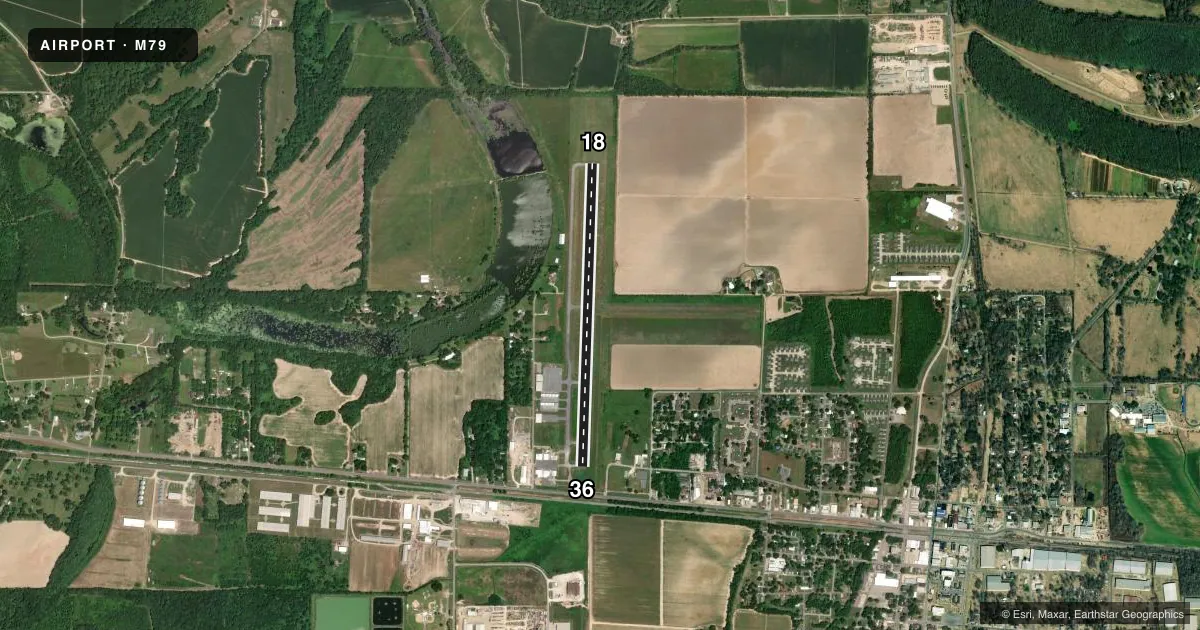
Runways & pattern
Full pagePattern entry · RWY 18
LEFT TRAFFICRunway end performance
| End | TORA | TODA | ASDA | LDA | VGSI | Approach lights | Obstruction |
|---|---|---|---|---|---|---|---|
| 18 | — | — | — | — | PAPI 2-box left(3°) | — | 83', trees, 2006' from thr, slope 21 |
| 36 | — | — | — | — | PAPI 2-box left(3°) | — | 27', trees, 465' from thr, 0' R of cntrln, slope 9 |
Declared distances in feet. TORA = takeoff run available, TODA = takeoff distance, ASDA = accelerate-stop, LDA = landing distance.
Airport sketch
Runways drawn to scale from FAA survey coordinates, rendered over satellite imagery. Not for navigation.
Approaches & charts
Services on the field
Fuel grades, oxygen, maintenance, ramp storage and lighting — as declared to the FAA by the airport operator.
Fuel & services
- Fuel
- Not available
- Oxygen (bottled)
- Not available
- Oxygen (bulk)
- Not available
- Airframe repair
- Major
- Power plant repair
- Major
- Other services
- AGRI,INSTR
Ramp & ground
- Transient storage
- Tie-down
- Landing fee
- No fee published
- Customs
- Not available
- Lighting schedule
- SEE RMK
- Beacon schedule
- SS-SR
- Beacon
- White / Green (civil land)(WG)
- Wind indicator
- Lighted
- Segmented circle
- No
Fuel & FBOs
Cheapest 100LL and Jet A on the field and nearby. Always confirm with the FBO before taxi.
Airport notes
Surface conditions, obstructions, local procedures, lighting outages and other notes published with each FAA cycle.
General notes
- ROAD 367 FT & RR TRACK 467 FT FM APCH END RY 36.
- RY 18/36 40-80 FT TREES WEST SIDE OF RY PENETRATE TRANSITION SLOPE.
- FOR CD CTC MONROE APCH AT 318-327-5641, IF UNAVBL, CTC FORT WORTH ARTCC AT 817-858-7584.
- CTC APRT MGR FOR DSGND RAMP SPACE FOR PUB USE.
Lighting notes
- DUSK-DAWN. MIRL RY 18/36, REIL RYS 18 & 36 PRESET LOW INTST DUSK-DAWN; TO INCR INTST ACTVT - CTAF.
Approach & departure obstructions
- 36APCH SLP 12:1 TO DSPLCD THLD.
Other notes
- PRE-DATES THE ACT.
- 2FOR SVCS AFT HRS CALL 318-235-3177.
VFR map & nearby airports
VFR sectional. Tap any ICAO chip to open that airport.
Key facts · M79
Answer card- ICAO
- M79
- Name
- JOHN H HOOKS JR MEML
- Location
- RAYVILLE, LOUISIANA
- Elevation
- 82.7 ft MSL
- Traffic pattern altitude
- 1,082.7 ft MSL (1,000 AGL)
- Control tower
- Non-towered (use CTAF)
- Total runways
- 1
- Longest runway
- 18/36 · 3,998 ft
- Published ILS approaches
- 0
- Published frequencies
- 3
- Magnetic variation
- 2°
- Current flight rules
- VFR
- Current wind
- 260° at 7 kt
- Favored runway now
- RWY 18
John H Hooks Jr Meml Airport sits in Rayville, Louisiana at 82.7 ft MSL. It has one runway, 18/36, which is 3,998 ft long and asphalt. The field is not towered. CTAF and UNICOM are both 122.8. Approach and departure service is on 126.9 with Monroe. No ILS approaches are published here.
Pattern altitude is not published. Use the standard 1,000 ft AGL for light piston traffic unless the current Chart Supplement says otherwise. Lighting runs from dusk to dawn. Runway 18/36 has medium intensity lights. The runway end identifier lights are preset low at night. Use the CTAF to raise intensity if needed.
First-time pilots should pay attention to the west side of the runway. Trees there penetrate the transition slope. There is also a road 367 ft from the approach end of runway 36. A railroad track sits 467 ft from that same end. The approach slope to the displaced threshold on runway 36 is 12 to 1. Contact the airport manager for designated public ramp space. FBO options vary. Contact the airport operator directly before arrival, or call the field on CTAF/UNICOM for current FBO availability. For services after hours, call the number listed in the remarks.