METAR & TAF 0M9
0M9 does not publish a METAR.
Showing the nearest reporting station: KTVR (VICKSBURG TALLULAH RGNL) · 24.1 NM away. Conditions at 0M9 may differ.
METAR · KTVR
Observed 05:53Z
KTVR 270553Z AUTO 00000KT 10SM CLR 25/24 A2997 RMK AO2 SLP153 T02500244 10317 20250 403500233 50005
- Wind
- 000° @ 0 kt
- Visibility
- 10 SM
- Temp / Dew
- 25°C / 24°C
- Altimeter
- 29.97 inHg
- Clouds
- CLR
- Density alt
- 1,251 ft
- Ceiling
- Unlimited
- Rules
- VFR
Airport info & contacts
Manager on record, flight service, ARTCC, attendance schedule and pattern altitude — published by the FAA and refreshed every 28 days.
Location
- From city
- 3 NM S
- VFR sectional
- MEMPHIS
- ARTCC
- ZFW · FORT WORTH
- NOTAM facility
- DRI (NOTAM-D)
Airport manager
- Name
- LOUIS MARTIN
- Phone
- (318) 614-9210
- Address
- 86 AIRPORT RD, DELHI LA 71232
Flight service · Hours
- FSS DRI
- DE RIDDER1-800-WX-BRIEF
- Attendance
- Unattended
Frequencies
Tap any row to copy the frequency to your clipboard.
Runways & pattern
Full pagePattern entry · RWY 18
LEFT TRAFFICRunway end performance
| End | TORA | TODA | ASDA | LDA | VGSI | Approach lights | Obstruction |
|---|---|---|---|---|---|---|---|
| 18 | — | — | — | — | — | — | 29', trees, 502' from thr, 141' R of cntrln, slope 10 |
| 36 | — | — | — | — | — | — | 15', road, 345' from thr, 0' R of cntrln, slope 10 |
Declared distances in feet. TORA = takeoff run available, TODA = takeoff distance, ASDA = accelerate-stop, LDA = landing distance.
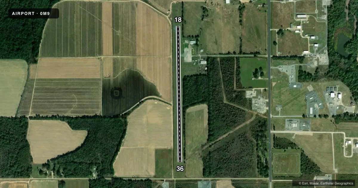
Airport sketch
Runways drawn to scale from FAA survey coordinates, rendered over satellite imagery. Not for navigation.
Approaches & charts
Services on the field
Fuel grades, oxygen, maintenance, ramp storage and lighting — as declared to the FAA by the airport operator.
Fuel & services
- Fuel
- Not available
- Other services
- AGRI
Ramp & ground
- Transient storage
- Tie-down
- Landing fee
- No fee published
- Lighting schedule
- SEE RMK
- Beacon schedule
- SS-SR
- Beacon
- White / Green (civil land)(WG)
- Wind indicator
- Lighted
- Segmented circle
- Yes
Fuel & FBOs
Cheapest 100LL and Jet A on the field and nearby. Always confirm with the FBO before taxi.
Airport notes
Surface conditions, obstructions, local procedures, lighting outages and other notes published with each FAA cycle.
General notes
- RY 18/36 4 FT FENCE 123 FT FM CNTRLN ON BOTH SIDES OF RY.
- FOR CD CTC MONROE APCH AT 318-327-5641, IF UNAVBL, CTC FORT WORTH ARTCC AT 817-858-7584.
- CTC APRT MGR FOR DSGND RAMP SPACE FOR PUB USE.
Lighting notes
- MIRL RY 18/36, REIL RYS 18 & 36 PRESET LOW INTST DUSK-DAWN; TO INCR INTST ACTVT - CTAF.
Approach & departure obstructions
- 1834 FT TREES 113 FT RIGHT OF CNTRLN 246 FT FM END OF RY; 28 FT TREES 124 FT LEFT OF CNTRLN 143 FT FM END OF RY.
- 3616 FT TREES 123 FT RIGHT OF CNTRLN 221 FT FM END OF RY.
- 18RWY 18 MARKINGS FADED
- 36RWY 36 MARKINGS FADED
- 36APCH SLOPE 20:1 TO DSPLCD THLD.
Other notes
- MAY BE EXEMPT UNDER GRANDFATHER CLAUSE.
VFR map & nearby airports
VFR sectional. Tap any ICAO chip to open that airport.
Key facts · 0M9
Answer card- ICAO
- 0M9
- Name
- DELHI MUNI
- Location
- DELHI, LOUISIANA
- Elevation
- 91 ft MSL
- Traffic pattern altitude
- 1,091 ft MSL (1,000 AGL)
- Control tower
- Non-towered (use CTAF)
- Total runways
- 1
- Longest runway
- 18/36 · 3,000 ft
- Published ILS approaches
- 0
- Published frequencies
- 1
- Magnetic variation
- 4°
- Current flight rules
- VFR
- Current wind
- 000° at 0 kt
- Favored runway now
- –
Delhi Muni is in Delhi, Louisiana. The field elevation is 91 ft MSL. It has one runway. Runway 18/36 is 3,000 ft long with asphalt pavement. There is no control tower, so traffic works on CTAF 122.9.
No ILS approaches are published here. The pattern altitude is not published, so use the standard 1,000 ft AGL for light piston operations unless the current FAA Chart Supplement says otherwise. The runway lights are medium intensity. The runway end identifier lights are preset low from dusk to dawn. You can raise intensity by keying the CTAF.
Published remarks matter here. Runway markings on both ends are faded. There are trees near both runway ends. Runway 36 also has a 20:1 approach slope to the displaced threshold. Clearance delivery is handled through Monroe Approach. If that is not available, contact Fort Worth ARTCC. There is no on-field FBO listed, so verify services with the airport operator or the FBO directly by phone before you go. Ask the airport manager about designated ramp space for public use. Pilots should also plan for the runway environment and keep an eye on the obstructions close to the centerline.