METAR & TAF 9M6
9M6 does not publish a METAR.
Showing the nearest reporting station: KBQP (MOREHOUSE MEML) · 24.7 NM away. Conditions at 9M6 may differ.
METAR · KBQP
Observed 12:10Z
KBQP 271210Z AUTO 00000KT OVC002 26/22 A3000 RMK AO2 T02580223 PWINO
- Wind
- 000° @ 0 kt
- Visibility
- —
- Temp / Dew
- 26°C / 22°C
- Altimeter
- 30.00 inHg
- Clouds
- OVC
- Density alt
- 1,360 ft
- Ceiling
- 200 ft AGL
- Rules
- LIFR
Airport info & contacts
Manager on record, flight service, ARTCC, attendance schedule and pattern altitude — published by the FAA and refreshed every 28 days.
Location
- From city
- 1 NM SW
- VFR sectional
- MEMPHIS
- ARTCC
- ZME · MEMPHIS
- NOTAM facility
- DRI (NOTAM-D)
Airport manager
- Name
- CLARK STRANGE
- Phone
- 318-428-3129
- Address
- 580 S. OLD LILBOURNE RD, OAK GROVE LA 71263
Flight service · Hours
- FSS DRI
- DE RIDDER1-800-WX-BRIEF
- Attendance
- MON-FRI · 0730-1700
Frequencies
Tap any row to copy the frequency to your clipboard.
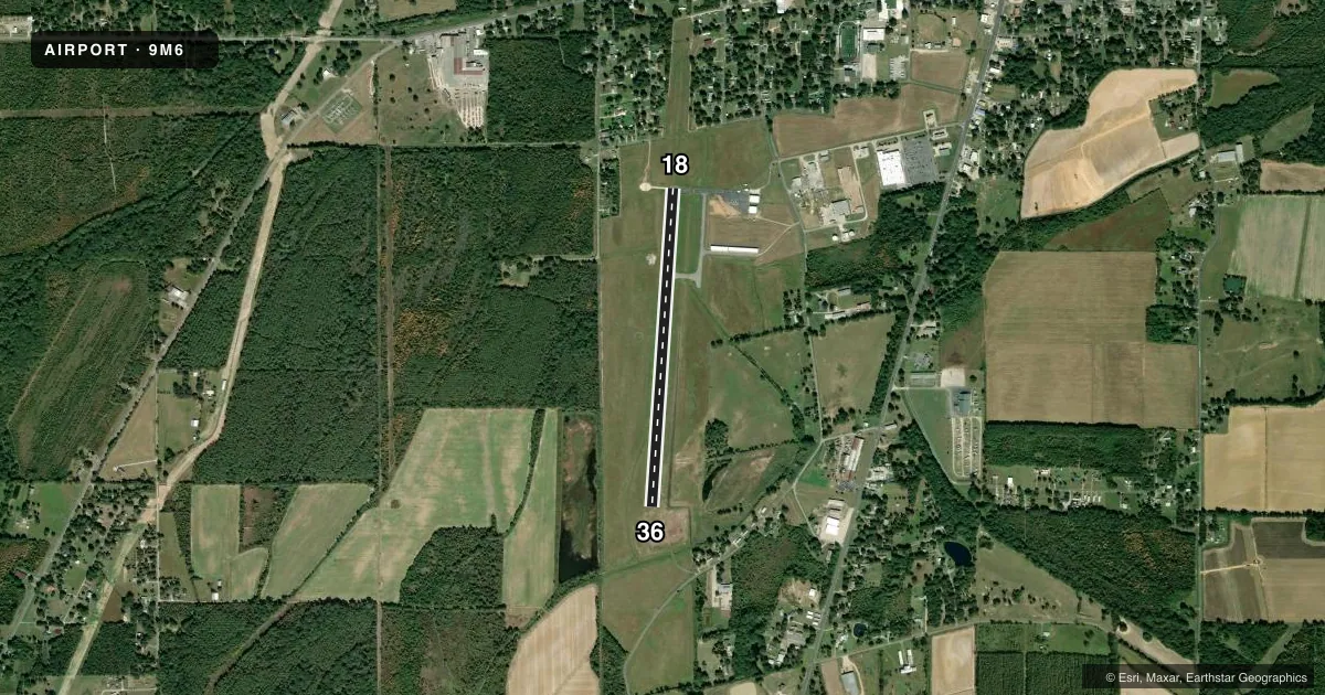
Runways & pattern
Full pagePattern entry · RWY 18
LEFT TRAFFICRunway end performance
| End | TORA | TODA | ASDA | LDA | VGSI | Approach lights | Obstruction |
|---|---|---|---|---|---|---|---|
| 18 | — | — | — | — | PAPI 2-box right(3.5°) | — | 64', trees, 1422' from thr, 137' R of cntrln, slope 19 |
| 36 | — | — | — | — | PAPI 2-box left(3°) | — | 91', trees, 2590' from thr, 360' R of cntrln, slope 26 |
Declared distances in feet. TORA = takeoff run available, TODA = takeoff distance, ASDA = accelerate-stop, LDA = landing distance.
Airport sketch
Runways drawn to scale from FAA survey coordinates, rendered over satellite imagery. Not for navigation.
Approaches & charts
Services on the field
Fuel grades, oxygen, maintenance, ramp storage and lighting — as declared to the FAA by the airport operator.
Fuel & services
- Fuel
- 100LLA
- Oxygen (bottled)
- Not available
- Oxygen (bulk)
- Not available
- Airframe repair
- Major
- Power plant repair
- Major
- Other services
- AGRI
Ramp & ground
- Transient storage
- Tie-down
- Landing fee
- No fee published
- Customs
- Not available
- Lighting schedule
- SEE RMK
- Beacon schedule
- SS-SR
- Beacon
- White / Green (civil land)(WG)
- Wind indicator
- Lighted
- Segmented circle
- Yes
Fuel & FBOs
Cheapest 100LL and Jet A on the field and nearby. Always confirm with the FBO before taxi.
Airport notes
Surface conditions, obstructions, local procedures, lighting outages and other notes published with each FAA cycle.
General notes
- FOR CD CTC MEMPHIS ARTCC AT 901-368-8453/8449.
- CTC ARPT MGR FOR DSNGD RAMP SPACE FOR PUB USE AT ARPT
Lighting notes
- MIRL RWY 18/36, REIL RWYS 18 & 36 PRESET LOW INTST DUSK-DAWN; TO INCR INTST ACTVT - CTAF. PAPI RWY 18 & 36 DUSK-DAWN - CTAF.
Fuel notes
- 100LLFUEL AVBL 24 HRS WITH CREDIT CARD.
Approach & departure obstructions
- 18APCH SLOPE 22:1 TO DSPLCD THLD.
VFR map & nearby airports
VFR sectional. Tap any ICAO chip to open that airport.
Key facts · 9M6
Answer card- ICAO
- 9M6
- Name
- KELLY-DUMAS
- Location
- OAK GROVE, LOUISIANA
- Elevation
- 111.9 ft MSL
- Traffic pattern altitude
- 1,111.9 ft MSL (1,000 AGL)
- Control tower
- Non-towered (use CTAF)
- Total runways
- 1
- Longest runway
- 18/36 · 3,799 ft
- Published ILS approaches
- 0
- Published frequencies
- 1
- Magnetic variation
- 3°
- Current flight rules
- LIFR
- Current wind
- 000° at 0 kt
- Favored runway now
- –
KELLY-DUMAS Airport (9M6) is in Oak Grove, Louisiana. Field elevation is 111.9 ft MSL. The airport has one runway. Runway 18/36 is 3,799 ft of asphalt. There is no control tower. CTAF is 122.9.
No ILS approaches are published here. Pattern altitude is not published in the facts, so use the current FAA Chart Supplement before you go. The field has medium intensity runway lights on 18/36. Runway end identifier lights are preset low from dusk to dawn. They can be brightened on CTAF. Precision approach path indicators on 18 and 36 also operate from dusk to dawn and are activated on CTAF.
Kelly-Dumas Airport is on field with Kelly-Dumas Airport FBO. It carries AVGAS 100LL and JET A. Fuel is available 24 hours with credit card. For clearance delivery, contact Memphis ARTCC. The published remarks also note that public ramp space is assigned by the airport manager. Runway 18 has a published 22 to 1 approach slope to the displaced threshold, so brief that into your arrival planning. This is a small non-towered field, so expect self-announce traffic and keep an eye on CTAF.