METAR & TAF 0M8
0M8 does not publish a METAR.
Showing the nearest reporting station: KTVR (VICKSBURG TALLULAH RGNL) · 29.6 NM away. Conditions at 0M8 may differ.
METAR · KTVR
Observed 09:53Z
KTVR 250953Z AUTO 14003KT 10SM SCT039 SCT045 BKN055 23/23 A3002 RMK AO2 SLP170 T02280228
- Wind
- 140° @ 3 kt
- Visibility
- 10 SM
- Temp / Dew
- 23°C / 23°C
- Altimeter
- 30.02 inHg
- Clouds
- BKN
- Density alt
- 967 ft
- Ceiling
- 5,500 ft AGL
- Rules
- VFR
Airport info & contacts
Manager on record, flight service, ARTCC, attendance schedule and pattern altitude — published by the FAA and refreshed every 28 days.
Location
- From city
- 2 NM N
- VFR sectional
- MEMPHIS
- ARTCC
- ZME · MEMPHIS
- NOTAM facility
- DRI (NOTAM-D)
Airport manager
- Name
- BARRY BOYETTE
- Phone
- (318) 282-9263
- Address
- 623 SCHNEIDER LANE, LAKE PROVIDENCE LA 71254
Flight service · Hours
- FSS DRI
- DE RIDDER1-800-WX-BRIEF
- Attendance
- Unattended
Frequencies
Tap any row to copy the frequency to your clipboard.
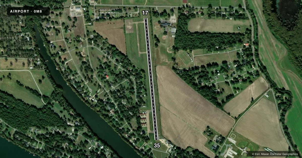
Runways & pattern
Full pagePattern entry · RWY 17
LEFT TRAFFICRunway end performance
| End | TORA | TODA | ASDA | LDA | VGSI | Approach lights | Obstruction |
|---|---|---|---|---|---|---|---|
| 17 | — | — | — | — | — | — | 15', road, 310' from thr, 0' R of cntrln, slope 7 |
| 35 | — | — | — | — | — | — | 106', trees, 710' from thr, 200' R of cntrln, slope 4 |
Declared distances in feet. TORA = takeoff run available, TODA = takeoff distance, ASDA = accelerate-stop, LDA = landing distance.
Airport sketch
Runways drawn to scale from FAA survey coordinates, rendered over satellite imagery. Not for navigation.
Approaches & charts
Services on the field
Fuel grades, oxygen, maintenance, ramp storage and lighting — as declared to the FAA by the airport operator.
Fuel & services
- Fuel
- Not available
- Oxygen (bottled)
- Not available
- Oxygen (bulk)
- Not available
- Airframe repair
- Not available
- Power plant repair
- Not available
- Other services
- AGRI
Ramp & ground
- Transient storage
- Not published
- Landing fee
- No fee published
- Customs
- Not available
- Beacon schedule
- SS-SR
- Beacon
- White / Green (civil land)(WG)
- Wind indicator
- Yes
- Segmented circle
- No
Fuel & FBOs
Cheapest 100LL and Jet A on the field and nearby. Always confirm with the FBO before taxi.
Airport notes
Surface conditions, obstructions, local procedures, lighting outages and other notes published with each FAA cycle.
General notes
- WEST APRON POOR CONDITION; GRAVEL& POTHOLES.
- DAY VFR ONLY.
- FOR CD CTC MEMPHIS ARTCC AT 901-368-8453/8449.
- CTC AMGR FOR DSGND RAMP SPACE FOR PUB USE
Lighting notes
- ROTG BCN OTS INDEFLY.
Approach & departure obstructions
- 17DSPLCD THLD NOT LIGHTED.
- 35DSPLCD THLD NOT LIGHTED.
- 17DSPLCD THLD MARKINGS NSTD; NO ARROW/CHEVRONS.
- 35NO HOLD SHORT LINE EAST SIDE OF RY 35.
- 17APCH RATIO 25:1 FM DSPLCD THLD.
- 35APCH RATIO 11:1 FM DSPLCD THLD.
Other notes
- THIS AIRPORT HAS BEEN SURVEYED BY THE NATIONAL GEODETIC SURVEY.
- PRE DATES THE ACT.
VFR map & nearby airports
VFR sectional. Tap any ICAO chip to open that airport.
Key facts · 0M8
Answer card- ICAO
- 0M8
- Name
- BYERLEY
- Location
- LAKE PROVIDENCE, LOUISIANA
- Elevation
- 106 ft MSL
- Traffic pattern altitude
- 1,106 ft MSL (1,000 AGL)
- Control tower
- Non-towered (use CTAF)
- Total runways
- 1
- Longest runway
- 17/35 · 3,196 ft
- Published ILS approaches
- 0
- Published frequencies
- 1
- Magnetic variation
- 3°
- Current flight rules
- VFR
- Current wind
- 140° at 3 kt
- Favored runway now
- RWY 17
BYERLEY (0M8) sits in Lake Providence, Louisiana. Field elevation is 106 ft MSL. The airport has one runway. Runway 17/35 is 3,196 ft long with an asphalt surface. There is no control tower. CTAF is 122.9. No ILS approaches are published here.
Pattern altitude is not published. Use 1,000 ft AGL as the standard light-piston pattern reference unless the current Chart Supplement says otherwise. The published remarks matter here. This is day VFR only. The rotating beacon is out of service indefinitely. Runway 17 and runway 35 both have displaced-threshold notes. The threshold on 35 is not lighted. The threshold on 17 is not lighted. The west apron is in poor condition with gravel and potholes. Contact the airport manager for designated ramp space before you go.
There are no on-field FBOs listed in the facts. Plan on verifying services with the airport operator or by calling the field directly before arrival. For a first-time pilot, the big items are the day-only limitation, the nonstandard displaced-threshold markings on runway 17 and the poor apron condition on the west side. Keep the runway length in mind. It is usable for light aircraft. Brief the displaced thresholds and the lack of lighting before you launch.