METAR & TAF KBQP
Current METAR
Observed 14:10Z
KBQP 261410Z AUTO 00000KT OVC002 29/23 A3007 RMK AO2 T02910227 PWINO
- Wind
- 000° @ 0 kt
- Visibility
- —
- Temp / Dew
- 29°C / 23°C
- Altimeter
- 30.07 inHg
- Clouds
- OVC
- Density alt
- 1,702 ft
- Ceiling
- 200 ft AGL
- Rules
- LIFR
Airport info & contacts
Manager on record, flight service, ARTCC, attendance schedule and pattern altitude — published by the FAA and refreshed every 28 days.
Location
- From city
- 2 NM SE
- VFR sectional
- MEMPHIS
- Pattern altitude
- 1,033 ft AGL · 1,201 ft MSL
- ARTCC
- ZFW · FORT WORTH
- NOTAM facility
- DRI (NOTAM-D)
Airport manager
- Name
- BRENT ELTON
- Phone
- 318-281-2018
- Address
- 6336 HOLLAND DRIVE, BASTROP LA 71220
Flight service · Hours
- FSS DRI
- DE RIDDER1-800-WX-BRIEF
- Attendance
- MON-FRI · 0715-1500
Frequencies
Tap any row to copy the frequency to your clipboard.
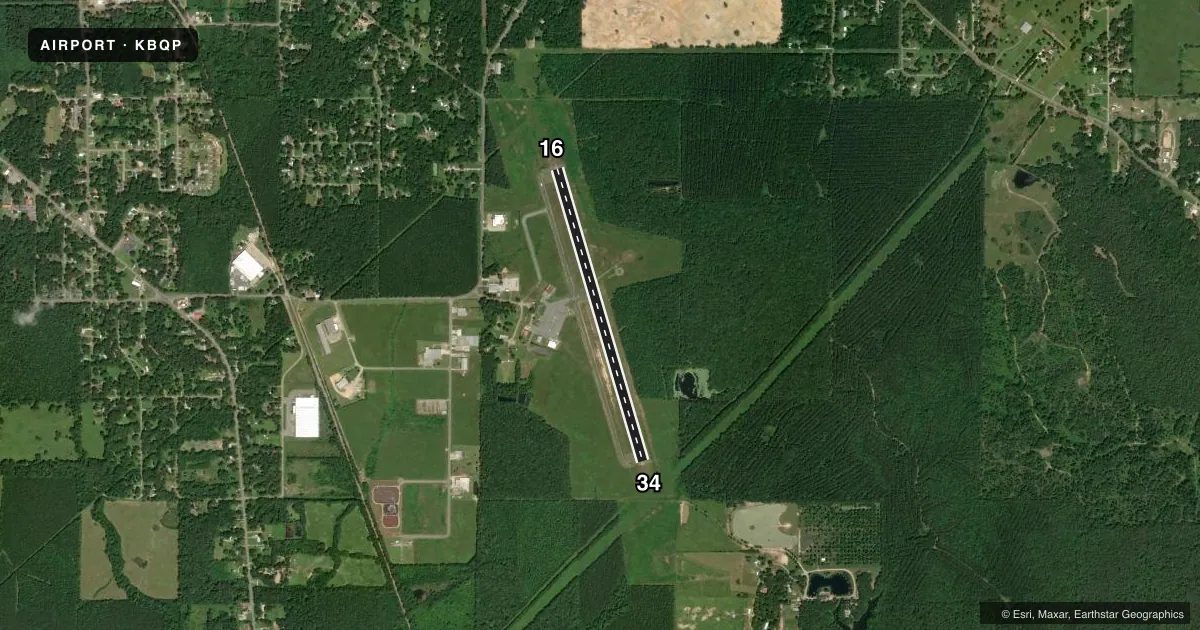
Runways & pattern
Full pagePattern entry · RWY 16
LEFT TRAFFICRunway end performance
| End | TORA | TODA | ASDA | LDA | VGSI | Approach lights | Obstruction |
|---|---|---|---|---|---|---|---|
| 16 | — | — | — | — | PAPI 2-box left(3°) | — | — |
| 34 | — | — | — | — | PAPI 2-box left(3°) | — | — |
Declared distances in feet. TORA = takeoff run available, TODA = takeoff distance, ASDA = accelerate-stop, LDA = landing distance.
Airport sketch
Runways drawn to scale from FAA survey coordinates, rendered over satellite imagery. Not for navigation.
Approaches & charts
Services on the field
Fuel grades, oxygen, maintenance, ramp storage and lighting — as declared to the FAA by the airport operator.
Fuel & services
- Fuel
- 100LL
- Oxygen (bottled)
- Not available
- Oxygen (bulk)
- Not available
- Airframe repair
- Minor
- Power plant repair
- Minor
Ramp & ground
- Transient storage
- Tie-down
- Landing fee
- No fee published
- Customs
- Not available
- Lighting schedule
- SEE RMK
- Beacon schedule
- SS-SR
- Beacon
- White / Green (civil land)(WG)
- Wind indicator
- Lighted
- Segmented circle
- No
Fuel & FBOs
Cheapest 100LL and Jet A on the field and nearby. Always confirm with the FBO before taxi.
Airport notes
Surface conditions, obstructions, local procedures, lighting outages and other notes published with each FAA cycle.
General notes
- DEER ON & INVOF RY.
- FOR CD CTC MONROE APCH AT 318-327-5641, IF UNAVBL, CTC FORT WORTH ARTCC AT 817-858-7584.
- CTC APRT MGR FOR DSGND RAMP SPACE FOR PUB USE.
Lighting notes
- DUSK-DAWN. REIL RWYS 16 & 34; MIRL RWY 16/34 PRESET LOW INTST DUSK-DAWN; TO INCR INTST ACTVT - CTAF.
Fuel notes
- 100LLSELF SERVE FUEL AVBL 24 HRS WITH CREDIT CARD.
Approach & departure obstructions
- 34RWY 34 REIL OTS INDEFLY.
- 16RWY MKGS IN POOR COND DUE TO FADING AND MOLD GROWTH.
- 34CRACKING, FADING, & MOLD GROWTH ON RWY MKGS.
- 16PAPI OTS INDEFLY.
Other notes
- /PRE DATES THE ACT.
VFR map & nearby airports
VFR sectional. Tap any ICAO chip to open that airport.
Key facts · KBQP
Answer card- ICAO
- KBQP
- Name
- MOREHOUSE MEML
- Location
- BASTROP, LOUISIANA
- Elevation
- 167.7 ft MSL
- Traffic pattern altitude
- 1,200.7 ft MSL (1,033 AGL)
- Control tower
- Non-towered (use CTAF)
- Total runways
- 1
- Longest runway
- 16/34 · 4,002 ft
- Published ILS approaches
- 0
- Published frequencies
- 4
- Magnetic variation
- 3°
- Current flight rules
- LIFR
- Current wind
- 000° at 0 kt
- Favored runway now
- –
Morehouse Memorial Airport is in Bastrop, Louisiana. The field elevation is 167.7 ft MSL. It has one runway, 16/34, which is 4,002 ft long and asphalt. There is no control tower. Pattern altitude is 1,033 ft AGL, which is 1,200.7 ft MSL.
No ILS approaches are published here. For clearance delivery, contact Monroe Approach. If that is unavailable, use Fort Worth ARTCC. The airport sits in a non-towered environment, so expect standard CTAF self-announce work. Deer are reported on and near the runway. That is worth keeping in mind on taxi, takeoff and landing.
Lighting is available from dusk to dawn. Runway end identifier lights are on runways 16 and 34. The medium intensity runway lights on 16/34 are preset to low intensity at night. Use the CTAF to increase intensity. The precision approach path indicator on runway 16 is out of service indefinitely. Runway 34 runway end identifier lights are also out of service indefinitely. Markings on both ends are reported in poor condition.
Morehouse Memorial Airport is the on-field FBO. It carries 100LL. Self-serve 100LL is available 24 hours with credit card. Contact the airport manager for designated ramp space for public use before you arrive.