METAR & TAF F87
F87 does not publish a METAR.
Showing the nearest reporting station: KRSN (RUSTON RGNL) · 18.0 NM away. Conditions at F87 may differ.
METAR · KRSN
Observed 04:35Z
KRSN 270435Z AUTO 18003KT 10SM CLR 25/25 A2997 RMK AO2 T02520252 $
- Wind
- 180° @ 3 kt
- Visibility
- 10 SM
- Temp / Dew
- 25°C / 25°C
- Altimeter
- 29.97 inHg
- Clouds
- CLR
- Density alt
- 1,285 ft
- Ceiling
- Unlimited
- Rules
- VFR
Airport info & contacts
Manager on record, flight service, ARTCC, attendance schedule and pattern altitude — published by the FAA and refreshed every 28 days.
Location
- From city
- 4 NM SE
- VFR sectional
- MEMPHIS
- ARTCC
- ZFW · FORT WORTH
- NOTAM facility
- DRI (NOTAM-D)
Airport manager
- Name
- NICHOLAS GREEN
- Phone
- 318-243-4155
- Address
- 152 AIRPORT DRIVE, FARMERVILLE LA 71241
Flight service · Hours
- FSS DRI
- DE RIDDER1-800-WX-BRIEF
- Attendance
- Unattended
Frequencies
Tap any row to copy the frequency to your clipboard.
Runways & pattern
Full pagePattern entry · RWY 16
LEFT TRAFFICRunway end performance
| End | TORA | TODA | ASDA | LDA | VGSI | Approach lights | Obstruction |
|---|---|---|---|---|---|---|---|
| 16 | — | — | — | — | PAPI 2-box left(3.83°) | — | 60', trees, 412' from thr, 259' R of cntrln, slope 3 |
| 34 | — | — | — | — | PAPI 2-box left(3°) | — | 52', trees, 1310' from thr, 182' R of cntrln, slope 21 |
Declared distances in feet. TORA = takeoff run available, TODA = takeoff distance, ASDA = accelerate-stop, LDA = landing distance.
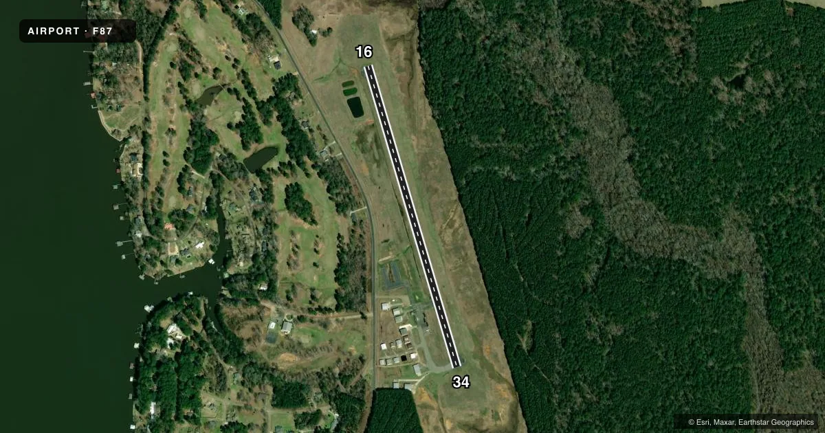
Airport sketch
Runways drawn to scale from FAA survey coordinates, rendered over satellite imagery. Not for navigation.
Approaches & charts
Services on the field
Fuel grades, oxygen, maintenance, ramp storage and lighting — as declared to the FAA by the airport operator.
Fuel & services
- Fuel
- 100LL
- Oxygen (bottled)
- Not available
- Oxygen (bulk)
- Not available
- Airframe repair
- Not available
- Power plant repair
- Not available
Ramp & ground
- Transient storage
- Tie-down
- Landing fee
- No fee published
- Customs
- Not available
- Lighting schedule
- SEE RMK
- Beacon schedule
- SS-SR
- Beacon
- White / Green (civil land)(WG)
- Wind indicator
- Lighted
- Segmented circle
- No
Fuel & FBOs
Cheapest 100LL and Jet A on the field and nearby. Always confirm with the FBO before taxi.
Airport notes
Surface conditions, obstructions, local procedures, lighting outages and other notes published with each FAA cycle.
General notes
- OXIDATION POND WITH 6 FT FENCE 150 FT WEST OF CNTRLN ON THE NORTH END OF RY 16.
- FOR CD CTC MONROE APCH AT 318-327-5641, IF UNAVBL, CTC FORT WORTH ARTCC AT 817-858-7584.
- CTC APRT MGR FOR DSGND RAMP SPACE FOR PUB USE.
Lighting notes
- MIRL RWY 16/34; REIL RWY 16 & 34 PRESET LOW INTST DUSK-DAWN; PAPI RWY 16 & 34; TO INCR INTST ACTVT - CTAF.
Runway surface & condition
- 16/34RWY CLSD TO ACFT OVER 12,500 LBS.
Other notes
- MANAGEREMAIL: BEECHCRAFT32J@GMAIL.COM.
VFR map & nearby airports
VFR sectional. Tap any ICAO chip to open that airport.
Key facts · F87
Answer card- ICAO
- F87
- Name
- UNION PARISH
- Location
- FARMERVILLE, LOUISIANA
- Elevation
- 118.7 ft MSL
- Traffic pattern altitude
- 1,118.7 ft MSL (1,000 AGL)
- Control tower
- Non-towered (use CTAF)
- Total runways
- 1
- Longest runway
- 16/34 · 3,003 ft
- Published ILS approaches
- 0
- Published frequencies
- 1
- Magnetic variation
- 5°
- Current flight rules
- VFR
- Current wind
- 180° at 3 kt
- Favored runway now
- RWY 16
Union Parish Airport sits in Farmerville, Louisiana. The field elevation is 118.7 ft MSL. It has one runway. Runway 16/34 is 3,003 ft long and paved with asphalt. The airport is non-towered, so CTAF is the main traffic advisory frequency. The published traffic pattern altitude is not listed. Use the standard 1,000 ft AGL pattern unless the current Chart Supplement says otherwise. That puts the pattern at about 1,118.7 ft MSL based on field elevation.
No ILS approaches are published here. Runway lighting is installed on 16/34. The runway end identifier lights are preset to low intensity from dusk to dawn. PAPI is installed on both ends. Light intensity can be increased by keying the lights on CTAF. The on-field FBO is Union Parish Airport. It carries AVGAS 100LL. Call ahead at (318) 366-0325 for current service details.
There are a few operational details worth planning for. Runway 16/34 is closed to aircraft over 12,500 lb. There is also an oxidation pond with a 6-foot fence about 150 ft west of the runway 16 centerline near the north end. For clearance delivery, contact Monroe Approach first. If that is unavailable, call Fort Worth ARTCC. Ramp space for public use is controlled by the airport manager. If you need current noise or ramp guidance, verify it with the airport operator before departure.