METAR & TAF 5F4
5F4 does not publish a METAR.
Showing the nearest reporting station: KMNE (MINDEN) · 17.2 NM away. Conditions at 5F4 may differ.
METAR · KMNE
Observed 13:35Z
KMNE 271335Z AUTO 23004KT 10SM CLR 27/22 A3001 RMK AO2
- Wind
- 230° @ 4 kt
- Visibility
- 10 SM
- Temp / Dew
- 27°C / 22°C
- Altimeter
- 30.01 inHg
- Clouds
- CLR
- Density alt
- 1,631 ft
- Ceiling
- Unlimited
- Rules
- VFR
Airport info & contacts
Manager on record, flight service, ARTCC, attendance schedule and pattern altitude — published by the FAA and refreshed every 28 days.
Location
- From city
- 3 NM E
- VFR sectional
- MEMPHIS
- ARTCC
- ZFW · FORT WORTH
- NOTAM facility
- DRI (NOTAM-D)
Airport manager
- Name
- JERRY WHITTON
- Phone
- 318-225-0911
- Address
- 550 AIRPORT LOOP, FIRE STATION, HOMER LA 71040
Flight service · Hours
- FSS DRI
- DE RIDDER1-800-WX-BRIEF
- Attendance
- Unattended
Frequencies
Tap any row to copy the frequency to your clipboard.
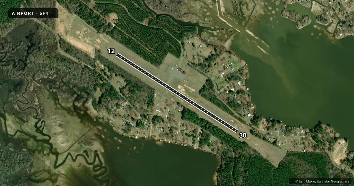
Runways & pattern
Full pagePattern entry · RWY 30
LEFT TRAFFICRunway end performance
| End | TORA | TODA | ASDA | LDA | VGSI | Approach lights | Obstruction |
|---|---|---|---|---|---|---|---|
| 12 | — | — | — | — | — | — | 63', trees, 356' from thr, 183' R of cntrln, slope 2 |
| 30 | — | — | — | — | — | — | 66', trees, 461' from thr, 283' R of cntrln, slope 3 |
Declared distances in feet. TORA = takeoff run available, TODA = takeoff distance, ASDA = accelerate-stop, LDA = landing distance.
Airport sketch
Runways drawn to scale from FAA survey coordinates, rendered over satellite imagery. Not for navigation.
Approaches & charts
Services on the field
Fuel grades, oxygen, maintenance, ramp storage and lighting — as declared to the FAA by the airport operator.
Fuel & services
- Fuel
- Not available
Ramp & ground
- Transient storage
- Tie-down
- Landing fee
- No fee published
- Customs
- Not available
- Lighting schedule
- SEE RMK
- Beacon schedule
- SS-SR
- Beacon
- White / Green (civil land)(WG)
- Wind indicator
- Lighted
- Segmented circle
- Yes
Fuel & FBOs
Cheapest 100LL and Jet A on the field and nearby. Always confirm with the FBO before taxi.
Airport notes
Surface conditions, obstructions, local procedures, lighting outages and other notes published with each FAA cycle.
General notes
- FOR CD CTC FORT WORTH ARTCC AT 817-858-7584.
- CTC APRT MGR FOR DSGND RAMP SPACE FOR PUB USE.
Lighting notes
- REIL RWY 12/30; MIRL RWY 12/30 PRESET LOW INTST DUSK-DAWN; TO INCR INTST ACTVT - CTAF.
Other notes
- 12/30EXCESSIVE RWY EDGE LIPS EXIST AFTER OVERLAY PROJECT. PILOTS ARE CAUTIONED TO STAY IN THE CTR OF THE RWY & TWY.
VFR map & nearby airports
VFR sectional. Tap any ICAO chip to open that airport.
Key facts · 5F4
Answer card- ICAO
- 5F4
- Name
- HOMER MUNI
- Location
- HOMER, LOUISIANA
- Elevation
- 244.1 ft MSL
- Traffic pattern altitude
- 1,244.1 ft MSL (1,000 AGL)
- Control tower
- Non-towered (use CTAF)
- Total runways
- 1
- Longest runway
- 12/30 · 3,200 ft
- Published ILS approaches
- 0
- Published frequencies
- 1
- Magnetic variation
- 2°
- Current flight rules
- VFR
- Current wind
- 230° at 4 kt
- Favored runway now
- RWY 30
Homer Muni sits in Homer, Louisiana. The field elevation is 244.1 ft MSL. It has one runway, 12/30, which is 3,200 ft long and paved asphalt. There is no control tower. CTAF is 122.9.
No ILS approaches are published here. The pattern altitude is not published, so use the standard 1,000 ft AGL for light piston operations unless the current FAA Chart Supplement says otherwise. The runway has end identifier lights. The medium intensity lights on 12/30 come up at low intensity from dusk to dawn. Use the CTAF to increase intensity if needed.
There are no on-field FBOs listed. Contact the airport manager for designated ramp space for public use before you go. Clearance delivery is handled through Fort Worth ARTCC at 817-858-7584. Pilots should also watch the runway and taxiway closely. The Chart Supplement notes excessive runway edge lips after the overlay project. Stay centered on the pavement. This is a small non-towered field. Plan your arrival carefully. Self-announce clearly. Verify current airport details before departure.