METAR & TAF 5F0
5F0 does not publish a METAR.
Showing the nearest reporting station: KRSN (RUSTON RGNL) · 18.5 NM away. Conditions at 5F0 may differ.
METAR · KRSN
Observed 20:55Z
KRSN 262055Z AUTO 21007KT 190V250 10SM FEW340 33/25 A3001 RMK AO2 T03270252 58009 $
- Wind
- 210° @ 7 kt
- Visibility
- 10 SM
- Temp / Dew
- 33°C / 25°C
- Altimeter
- 30.01 inHg
- Clouds
- FEW
- Density alt
- 2,594 ft
- Ceiling
- Unlimited
- Rules
- VFR
Airport info & contacts
Manager on record, flight service, ARTCC, attendance schedule and pattern altitude — published by the FAA and refreshed every 28 days.
Location
- From city
- 2 NM SW
- VFR sectional
- MEMPHIS
- ARTCC
- ZFW · FORT WORTH
- NOTAM facility
- DRI (NOTAM-D)
Airport manager
- Name
- ANTOINE HAMPTON
- Phone
- 318-263-8456
- Address
- PO BOX 767, ARCADIA LA 71001
Flight service · Hours
- FSS DRI
- DE RIDDER1-800-WX-BRIEF
- Attendance
- Unattended
Frequencies
Tap any row to copy the frequency to your clipboard.
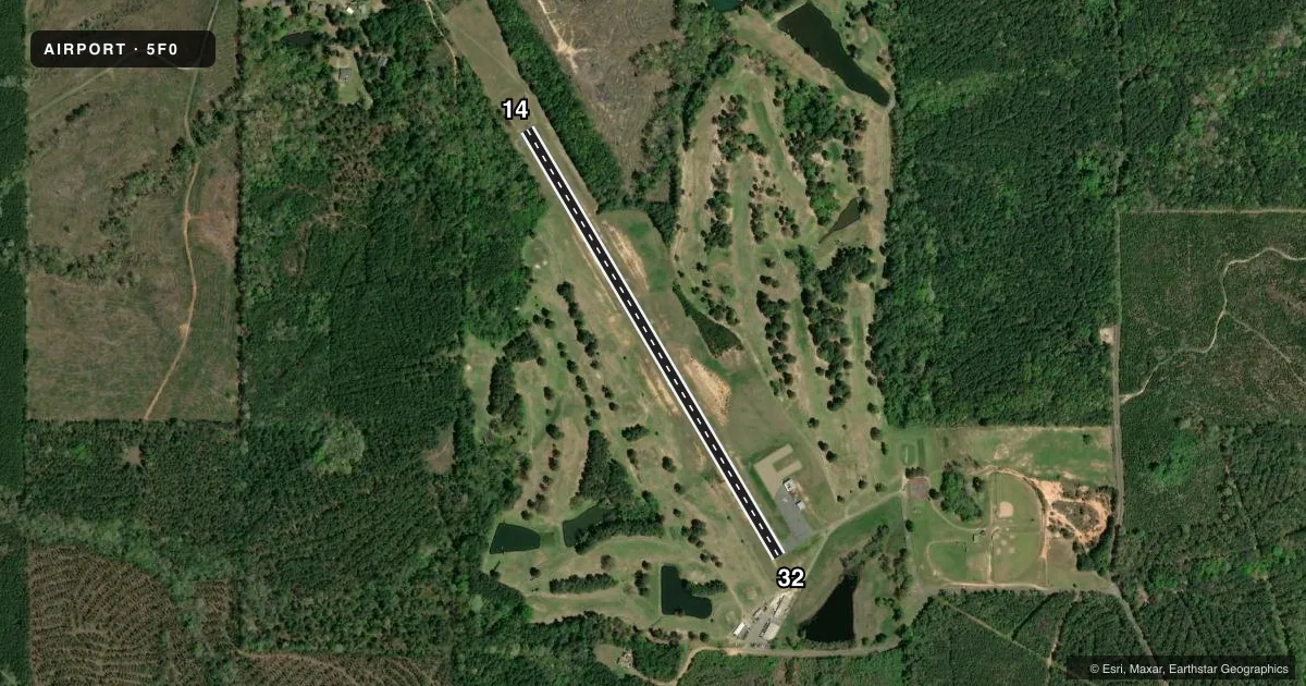
Runways & pattern
Full pagePattern entry · RWY 14
LEFT TRAFFICRunway end performance
| End | TORA | TODA | ASDA | LDA | VGSI | Approach lights | Obstruction |
|---|---|---|---|---|---|---|---|
| 14 | — | — | — | — | — | — | 76', trees, 1836' from thr, 318' R of cntrln, slope 21 |
| 32 | — | — | — | — | — | — | 47', trees, 769' from thr, 0' R of cntrln, slope 11 |
Declared distances in feet. TORA = takeoff run available, TODA = takeoff distance, ASDA = accelerate-stop, LDA = landing distance.
Airport sketch
Runways drawn to scale from FAA survey coordinates, rendered over satellite imagery. Not for navigation.
Approaches & charts
Services on the field
Fuel grades, oxygen, maintenance, ramp storage and lighting — as declared to the FAA by the airport operator.
Fuel & services
- Fuel
- Not available
- Oxygen (bottled)
- Not available
- Oxygen (bulk)
- Not available
- Airframe repair
- Not available
- Power plant repair
- Not available
Ramp & ground
- Transient storage
- Not published
- Landing fee
- No fee published
- Customs
- Not available
- Lighting schedule
- SEE RMK
- Beacon schedule
- SS-SR
- Beacon
- White / Green (civil land)(WG)
- Wind indicator
- Yes
- Segmented circle
- No
Fuel & FBOs
Cheapest 100LL and Jet A on the field and nearby. Always confirm with the FBO before taxi.
Airport notes
Surface conditions, obstructions, local procedures, lighting outages and other notes published with each FAA cycle.
General notes
- GOLF CRS ADJ TO ARPT.
- HOLD SHRT LINE NSTD DIST FM RWY.
- FOR CD CTC FORT WORTH ARTCC AT 817-858-7584.
- ROTG BCN 0.5 MILE SE OF ARPT OTS
- CTC APRT MGR FOR DSGND RAMP SPACE FOR PUB USE
Lighting notes
- ACTVT MIRL RWY 14/32 - CTAF.
Runway surface & condition
- 14/32MIRLS RWY 14/32 OTS INDEFLY.
Approach & departure obstructions
- 32GOLF CART PATH ROAD 193 FT FROM END OF RWY.
- 1430 FT TREES 221 FT FM END OF RWY 103 FT RIGHT OF CNTRLN.
Other notes
- 1FOR ARPT ATTENDANT CALL 318-263-2013.
VFR map & nearby airports
VFR sectional. Tap any ICAO chip to open that airport.
Key facts · 5F0
Answer card- ICAO
- 5F0
- Name
- ARCADIA-BIENVILLE PARISH
- Location
- ARCADIA, LOUISIANA
- Elevation
- 440 ft MSL
- Traffic pattern altitude
- 1,440 ft MSL (1,000 AGL)
- Control tower
- Non-towered (use CTAF)
- Total runways
- 1
- Longest runway
- 14/32 · 3,000 ft
- Published ILS approaches
- 0
- Published frequencies
- 1
- Magnetic variation
- 4°
- Current flight rules
- VFR
- Current wind
- 210° at 7 kt
- Favored runway now
- RWY 14
Arcadia-Bienville Parish Airport (5F0) sits in Arcadia, Louisiana at 440 ft MSL. It has one runway, 14/32, which is 3,000 ft long and asphalt. There is no control tower. CTAF is 122.9. No ILS approaches are published here.
The pattern altitude is not published. For light piston traffic, use 1,000 ft AGL unless the current Chart Supplement or local procedures say otherwise. The runway lights on 14/32 are medium intensity and activate on CTAF. The runway lighting system is reported out of service indefinitely. Verify lighting status before a night arrival.
No on-field FBOs are listed. Contact the airport operator or the airport attendant at 318-263-2013 for current ramp space and services. Published remarks also note a rotating beacon southeast of the airport that is out of service. There is a golf course next to the field. Watch the runway ends closely. Trees sit near the departure end of runway 14. A golf cart path road is near the departure end of runway 32. The hold short line is not a standard distance from the runway. Brief that with anyone new to the field before you taxi.