METAR & TAF F88
F88 does not publish a METAR.
Showing the nearest reporting station: KRSN (RUSTON RGNL) · 20.1 NM away. Conditions at F88 may differ.
METAR · KRSN
Observed 12:15Z
KRSN 271215Z AUTO 00000KT 8SM CLR 25/25 A2999 RMK AO2 T02460246 $
- Wind
- 000° @ 0 kt
- Visibility
- 8 SM
- Temp / Dew
- 25°C / 25°C
- Altimeter
- 29.99 inHg
- Clouds
- CLR
- Density alt
- 1,430 ft
- Ceiling
- Unlimited
- Rules
- VFR
Airport info & contacts
Manager on record, flight service, ARTCC, attendance schedule and pattern altitude — published by the FAA and refreshed every 28 days.
Location
- From city
- 3 NM S
- VFR sectional
- MEMPHIS
- ARTCC
- ZFW · FORT WORTH
- NOTAM facility
- DRI (NOTAM-D)
Airport manager
- Name
- JAMES BRADFORD
- Phone
- 318-680-8070
- Address
- 128 ALLEN AVE, JONESBORO LA 71251
Flight service · Hours
- FSS DRI
- DE RIDDER1-800-WX-BRIEF
- Attendance
- Unattended
Frequencies
Tap any row to copy the frequency to your clipboard.
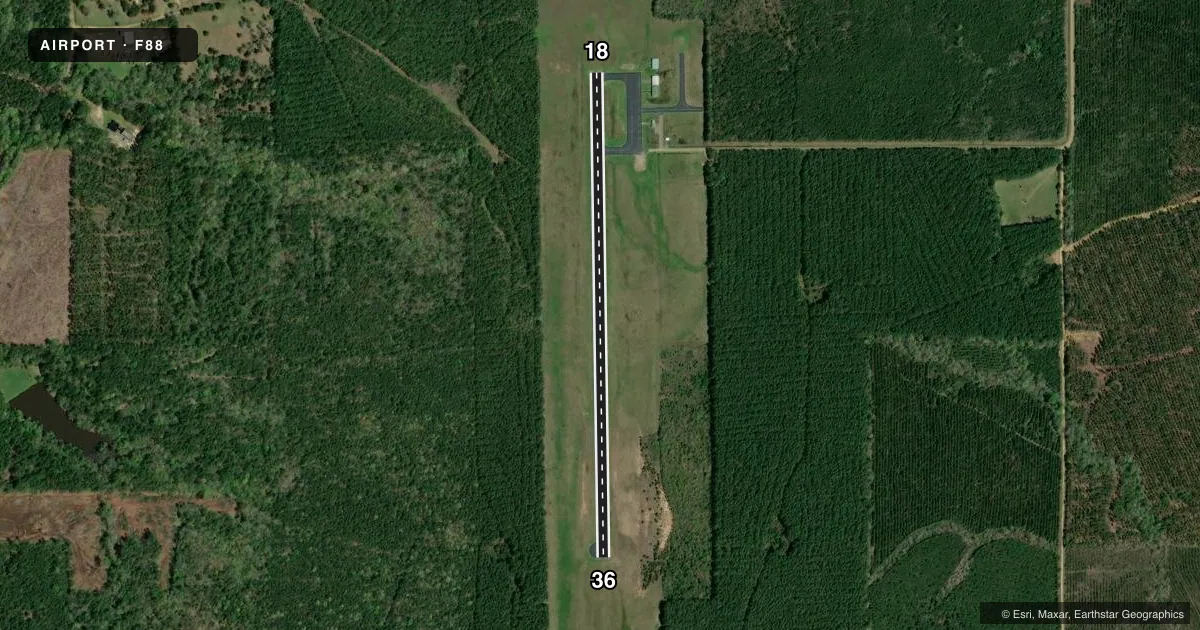
Runways & pattern
Full pagePattern entry · RWY 18
LEFT TRAFFICRunway end performance
| End | TORA | TODA | ASDA | LDA | VGSI | Approach lights | Obstruction |
|---|---|---|---|---|---|---|---|
| 18 | — | — | — | — | PAPI 2-box left(3°) | — | 80', trees, 2250' from thr, 0' R of cntrln, slope 25 |
| 36 | — | — | — | — | PAPI 2-box left(3°) | — | 85', trees, 2693' from thr, 46' R of cntrln, slope 29 |
Declared distances in feet. TORA = takeoff run available, TODA = takeoff distance, ASDA = accelerate-stop, LDA = landing distance.
Airport sketch
Runways drawn to scale from FAA survey coordinates, rendered over satellite imagery. Not for navigation.
Approaches & charts
Services on the field
Fuel grades, oxygen, maintenance, ramp storage and lighting — as declared to the FAA by the airport operator.
Fuel & services
- Fuel
- Not available
- Oxygen (bottled)
- Not available
- Oxygen (bulk)
- Not available
- Airframe repair
- Not available
- Power plant repair
- Not available
Ramp & ground
- Transient storage
- Tie-down
- Landing fee
- No fee published
- Customs
- Not available
- Lighting schedule
- SEE RMK
- Beacon schedule
- SS-SR
- Beacon
- White / Green (civil land)(WG)
- Wind indicator
- Yes
- Segmented circle
- Yes
Fuel & FBOs
Cheapest 100LL and Jet A on the field and nearby. Always confirm with the FBO before taxi.
Airport notes
Surface conditions, obstructions, local procedures, lighting outages and other notes published with each FAA cycle.
General notes
- DEER AND WILDLIFE ON & INVOF ARPT.
- SOUTH HOLD LINE NSTD DISTANCE FM RY CNTRLN.
- FOR CD CTC MONROE APCH AT 318-327-5641, IF UNAVBL, CTC FORT WORTH ARTCC AT 817-858-7584.
- CTC APRT MGR FOR DSGND RAMP SPACE FOR PUB USE.
Lighting notes
- REIL RWYS 18 & 36 AND MIRL RWY 18/36, PRESET LOW INTST; TO INCR INTST ACTVT - CTAF. PAPI RWY 36 OTS INDEFLY.
Other notes
- MAY BE EXEMPT UNDER GRANDFATHER CLAUSE.
- LGTD WINDSOCK OTS MIDFIELD.
VFR map & nearby airports
VFR sectional. Tap any ICAO chip to open that airport.
Key facts · F88
Answer card- ICAO
- F88
- Name
- JONESBORO
- Location
- JONESBORO, LOUISIANA
- Elevation
- 255.6 ft MSL
- Traffic pattern altitude
- 1,255.6 ft MSL (1,000 AGL)
- Control tower
- Non-towered (use CTAF)
- Total runways
- 1
- Longest runway
- 18/36 · 3,204 ft
- Published ILS approaches
- 0
- Published frequencies
- 3
- Magnetic variation
- 1°
- Current flight rules
- VFR
- Current wind
- 000° at 0 kt
- Favored runway now
- –
Jonesboro Airport is in Jonesboro, Louisiana. The field elevation is 255.6 ft MSL. It has one runway. Runway 18/36 is 3,204 ft long and asphalt. There is no control tower. The published pattern altitude is not listed, so use the standard 1,000 ft AGL for light piston traffic unless the current Chart Supplement says otherwise.
No ILS approaches are published here. The airport sits in a non-towered environment, so expect self-announce traffic on CTAF 122.9 and coordinate with Monroe Approach for IFR or clearance delivery needs. Published remarks note that runway end identifier lights are installed on 18 and 36. Medium intensity runway lights are on runway 18/36 and start at low intensity. You can increase intensity by keying the CTAF. The PAPI for runway 36 is out of service indefinitely. Deer and other wildlife are reported on and near the airport, so a careful scan on arrival and departure makes sense.
There are no on-field FBOs listed. Contact the airport operator directly before arrival if you need ramp space for public use. The published remarks also note that the south hold line is not a standard distance from the runway centerline. For clearance delivery, Monroe Approach is listed in the remarks. If that is unavailable, Fort Worth ARTCC is the backup contact.