METAR & TAF 0R7
0R7 does not publish a METAR.
Showing the nearest reporting station: KIER (NATCHITOCHES RGNL) · 18.6 NM away. Conditions at 0R7 may differ.
METAR · KIER
Observed 09:55Z
KIER 270955Z AUTO 00000KT 10SM CLR 25/25 A2996 RMK AO2 T02470247
- Wind
- 000° @ 0 kt
- Visibility
- 10 SM
- Temp / Dew
- 25°C / 25°C
- Altimeter
- 29.96 inHg
- Clouds
- CLR
- Density alt
- 1,370 ft
- Ceiling
- Unlimited
- Rules
- VFR
Airport info & contacts
Manager on record, flight service, ARTCC, attendance schedule and pattern altitude — published by the FAA and refreshed every 28 days.
Location
- From city
- 2 NM SE
- VFR sectional
- HOUSTON
- ARTCC
- ZHU · HOUSTON
- NOTAM facility
- DRI (NOTAM-D)
Airport manager
- Name
- JESSIE DAVIS
- Phone
- 318-932-5710
- Address
- PO DRAWER 709, COUSHATTA LA 71019
Flight service · Hours
- FSS DRI
- DE RIDDER1-800-WX-BRIEF
- Attendance
- Unattended
Frequencies
Tap any row to copy the frequency to your clipboard.
Runways & pattern
Full pagePattern entry · RWY 18
LEFT TRAFFICRunway end performance
| End | TORA | TODA | ASDA | LDA | VGSI | Approach lights | Obstruction |
|---|---|---|---|---|---|---|---|
| 18 | — | — | — | — | PAPI 2-box left(3°) | — | 53', trees, 1262' from thr, 243' R of cntrln, slope 20 |
| 36 | — | — | — | — | PAPI 2-box left(3°) | — | 104', trees, 2195' from thr, 229' R of cntrln, slope 19 |
Declared distances in feet. TORA = takeoff run available, TODA = takeoff distance, ASDA = accelerate-stop, LDA = landing distance.
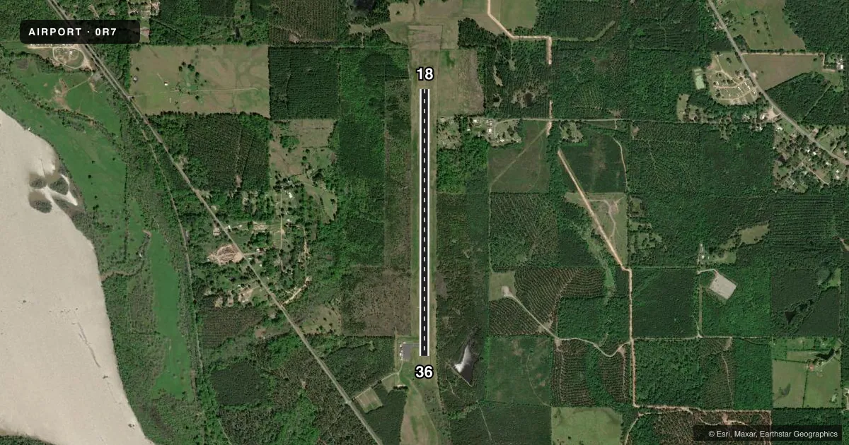
Airport sketch
Runways drawn to scale from FAA survey coordinates, rendered over satellite imagery. Not for navigation.
Approaches & charts
Services on the field
Fuel grades, oxygen, maintenance, ramp storage and lighting — as declared to the FAA by the airport operator.
Fuel & services
- Fuel
- Not available
- Oxygen (bottled)
- Not available
- Oxygen (bulk)
- Not available
- Airframe repair
- Not available
- Power plant repair
- Not available
Ramp & ground
- Transient storage
- Tie-down
- Landing fee
- No fee published
- Customs
- Not available
- Lighting schedule
- SEE RMK
- Beacon schedule
- SS-SR
- Beacon
- White / Green (civil land)(WG)
- Wind indicator
- Lighted
- Segmented circle
- No
Fuel & FBOs
Cheapest 100LL and Jet A on the field and nearby. Always confirm with the FBO before taxi.
Airport notes
Surface conditions, obstructions, local procedures, lighting outages and other notes published with each FAA cycle.
General notes
- 66 FT TREES 253 FT EAST OF RWY CNTRLN FULL LENGTH.
- FOR CD CTC FORT WORTH ARTCC AT 817-858-7584.
- CTC APRT MGR FOR DSGND RAMP SPACE FOR PUB USE.
Lighting notes
- AIRPORT BEACON OUT OF SERVICE
- MIRL RY 18/36, REIL RYS 18 & 36 PRESET LOW INTST DUSK-DAWN; TO INCR INTST ACTVT - CTAF.
Approach & departure obstructions
- 18RWY 18 REILS OUT OF SERVICE
- 36RWY 36 REILS OUT OF SERVICE
- 18RWY 18 PAPI OUT OF SERVICE
- 36RWY 36 PAPI OUT OF SERVICE
VFR map & nearby airports
VFR sectional. Tap any ICAO chip to open that airport.
Key facts · 0R7
Answer card- ICAO
- 0R7
- Name
- THE RED RIVER
- Location
- COUSHATTA, LOUISIANA
- Elevation
- 177.2 ft MSL
- Traffic pattern altitude
- 1,177.2 ft MSL (1,000 AGL)
- Control tower
- Non-towered (use CTAF)
- Total runways
- 1
- Longest runway
- 18/36 · 5,002 ft
- Published ILS approaches
- 0
- Published frequencies
- 3
- Magnetic variation
- 1°
- Current flight rules
- VFR
- Current wind
- 000° at 0 kt
- Favored runway now
- –
The Red River Airport (0R7) sits in Coushatta, Louisiana. Field elevation is 177.2 ft MSL. The airport has one runway. Runway 18/36 is 5,002 ft of asphalt. There is no control tower. The pattern altitude is not published, so use the standard 1,000 ft AGL for light piston operations unless the current Chart Supplement says otherwise.
No ILS approaches are published here. The runway has medium intensity lights. The runway end identifier lights are preset low from dusk to dawn. You can raise intensity on CTAF. The airport beacon is out of service. PAPI is out of service on both runway ends. There are also 66 ft trees 253 ft east of the runway centerline for the full length of the runway, so plan your departure and arrival path with that in mind.
No on-field FBOs are listed. Contact the airport manager for designated ramp space before arrival. For clearance delivery, Fort Worth ARTCC handles it at 817-858-7584. If you are new to the field, note the lack of tower service and the published lighting issues. That makes a current briefing important before a night arrival or a low-visibility departure.