METAR & TAF 5F5
5F5 does not publish a METAR.
Showing the nearest reporting station: KSHV (SHREVEPORT RGNL) · 6.3 NM away. Conditions at 5F5 may differ.
METAR · KSHV
Observed 02:56Z
KSHV 270256Z 21006KT 10SM CLR 30/21 A2995 RMK SLPNO
- Wind
- 210° @ 6 kt
- Visibility
- 10 SM
- Temp / Dew
- 30°C / 21°C
- Altimeter
- 29.95 inHg
- Clouds
- CLR
- Density alt
- 1,986 ft
- Ceiling
- Unlimited
- Rules
- VFR
Airport info & contacts
Manager on record, flight service, ARTCC, attendance schedule and pattern altitude — published by the FAA and refreshed every 28 days.
Location
- From city
- 2 NM NE
- VFR sectional
- MEMPHIS
- ARTCC
- ZFW · FORT WORTH
- NOTAM facility
- DRI (NOTAM-D)
Airport manager
- Name
- BILL LEDGER
- Phone
- 903-503-8505
- Address
- 2569 BARRON ROAD, KEITHVILLE LA 71047
Flight service · Hours
- FSS DRI
- DE RIDDER1-800-WX-BRIEF
- Attendance
- ALL
Frequencies
Tap any row to copy the frequency to your clipboard.
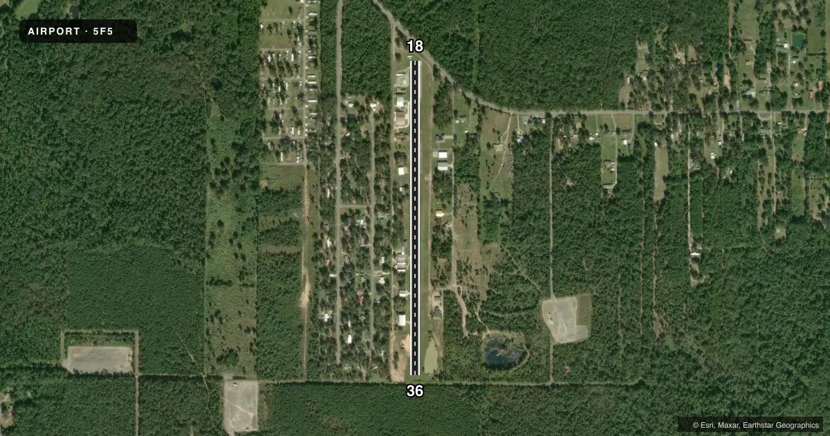
Runways & pattern
Full pagePattern entry · RWY 18
LEFT TRAFFICRunway end performance
| End | TORA | TODA | ASDA | LDA | VGSI | Approach lights | Obstruction |
|---|---|---|---|---|---|---|---|
| 18 | — | — | — | — | — | — | 57', trees, 309' from thr, 0' R of cntrln, slope 1 |
| 36 | — | — | — | — | — | — | 20', trees, 229' from thr, 0' R of cntrln, slope 11 |
Declared distances in feet. TORA = takeoff run available, TODA = takeoff distance, ASDA = accelerate-stop, LDA = landing distance.
Airport sketch
Runways drawn to scale from FAA survey coordinates, rendered over satellite imagery. Not for navigation.
Approaches & charts
Services on the field
Fuel grades, oxygen, maintenance, ramp storage and lighting — as declared to the FAA by the airport operator.
Fuel & services
- Fuel
- Not available
- Oxygen (bottled)
- Not available
- Oxygen (bulk)
- Not available
- Airframe repair
- Minor
- Power plant repair
- Minor
Ramp & ground
- Transient storage
- Tie-down
- Hangar
- Landing fee
- No fee published
- Lighting schedule
- SS-SR
- Beacon schedule
- SEE RMK
- Beacon
- White / Green (civil land)(WG)
- Wind indicator
- Yes
- Segmented circle
- No
Fuel & FBOs
Cheapest 100LL and Jet A on the field and nearby. Always confirm with the FBO before taxi.
Airport notes
Surface conditions, obstructions, local procedures, lighting outages and other notes published with each FAA cycle.
General notes
- FOR CD CTC FORT WORTH ARTCC AT 817-858-7584.
Lighting notes
- BCN OTS
Runway surface & condition
- 18/36CLSD SS-SR.
- 18/36RWY 18/36 430 FT ASPH ON RWY 18 END, 2570 FT TURF ON RWY 36 END.
Approach & departure obstructions
- 18+ 32 FT MKD PWR LINES BOTH SIDES OF CNTRLN 156 FT FM RWY END.
- 18RWY 18/36 DSPLCD THRS MKD WITH ONE ORANGE CONE ON EACH SIDE. RWY ENDS STOP AT 50 FT: TREES.
- 18APCH RATIO 12:1 TO DSPLCD THR.
- 36APCH RATIO 20:1 TO DSPLCD THR.
VFR map & nearby airports
VFR sectional. Tap any ICAO chip to open that airport.
Key facts · 5F5
Answer card- ICAO
- 5F5
- Name
- BLUEBIRD HILL
- Location
- KEITHVILLE, LOUISIANA
- Elevation
- 180 ft MSL
- Traffic pattern altitude
- 1,180 ft MSL (1,000 AGL)
- Control tower
- Non-towered (use CTAF)
- Total runways
- 1
- Longest runway
- 18/36 · 3,000 ft
- Published ILS approaches
- 0
- Published frequencies
- 1
- Magnetic variation
- 5°
- Current flight rules
- VFR
- Current wind
- 210° at 6 kt
- Favored runway now
- RWY 18
Bluebird Hill (5F5) is in Keithville, Louisiana. Field elevation is 180 ft MSL. The airport has one runway. It is runway 18/36 at 3,000 ft, with asphalt on the runway 18 end and turf on the runway 36 end. There is no control tower. CTAF is 122.9. No ILS approaches are published.
Pattern altitude is not published. Use 1,000 ft AGL for light piston operations unless the current Chart Supplement says otherwise. The published remarks matter here. Runway 18/36 is closed from sunset to sunrise. There are marked power lines near the runway 18 end. The approach to runway 18 also has a displaced threshold and trees close enough that the runway ends stop at 50 feet. The beacon is out of service.
There are no on-field FBOs listed. Plan on self-briefing and call the airport operator or the FBO directly by phone if you need current fuel or service details. Clearance delivery is handled through Fort Worth ARTCC at 817-858-7584. This is an uncontrolled field with a short runway and published obstructions. Give yourself extra room on arrival and departure. Check the current FAA Chart Supplement before flying in, especially if you are planning a night stop or a first visit.