METAR & TAF KASL
Current METAR
Observed 21:35Z
KASL 262135Z AUTO 16006KT 10SM CLR 36/17 A2997 RMK AO2 T03600170 $
- Wind
- 160° @ 6 kt
- Visibility
- 10 SM
- Temp / Dew
- 36°C / 17°C
- Altimeter
- 29.97 inHg
- Clouds
- CLR
- Density alt
- 2,901 ft
- Ceiling
- Unlimited
- Rules
- VFR
Airport info & contacts
Manager on record, flight service, ARTCC, attendance schedule and pattern altitude — published by the FAA and refreshed every 28 days.
Location
- From city
- 3 NM SE
- VFR sectional
- MEMPHIS
- ARTCC
- ZFW · FORT WORTH
- NOTAM facility
- FTW (NOTAM-D)
Airport manager
- Name
- DANIEL AIELLO
- Phone
- 903-938-1394
- Address
- 2100 WARREN DR., MARSHALL TX 75672
Flight service · Hours
- FSS FTW
- FORT WORTH1-800-WX-BRIEF
- Attendance
- MON-SAT · 0800-1700
- SUN · IREG
Frequencies
Tap any row to copy the frequency to your clipboard.
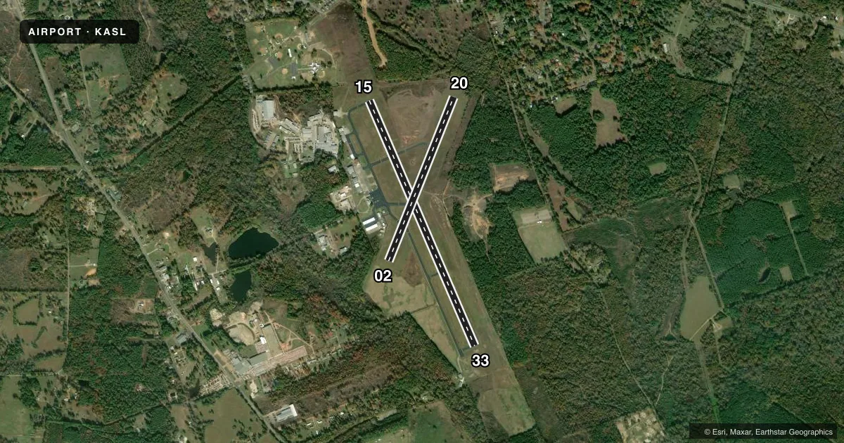
Runways & pattern
Full pagePattern entry · RWY 15
LEFT TRAFFIC| Runway | Heading (°M) | Length | Surface | Traffic |
|---|---|---|---|---|
| 15/33Favored | 154° / 334° | 5,002 ft | ASPH | Standard L |
| 02/20 | 19° / 199° | 3,304 ft | ASPH | Standard L |
Runway end performance
| End | TORA | TODA | ASDA | LDA | VGSI | Approach lights | Obstruction |
|---|---|---|---|---|---|---|---|
| 15 | — | — | — | — | — | — | 7', fence, 228' from thr, 250' R of cntrln, slope 4 |
| 33 | — | — | — | — | — | — | 45', trees, 900' from thr, 315' R of cntrln, slope 15 |
| 02 | — | — | — | — | — | — | 81', trees, 1436' from thr, 245' R of cntrln, slope 15 |
| 20 | — | — | — | — | — | — | 46', trees, 397' from thr, 155' R of cntrln, slope 4 |
Declared distances in feet. TORA = takeoff run available, TODA = takeoff distance, ASDA = accelerate-stop, LDA = landing distance.
Airport sketch
Runways drawn to scale from FAA survey coordinates, rendered over satellite imagery. Not for navigation.
Approaches & charts
Services on the field
Fuel grades, oxygen, maintenance, ramp storage and lighting — as declared to the FAA by the airport operator.
Fuel & services
- Fuel
- 100LLA
- Oxygen (bottled)
- HIGH/LOW
- Oxygen (bulk)
- HIGH/LOW
- Airframe repair
- Major
- Power plant repair
- Major
- Other services
- INSTR,RNTL,SALES
Ramp & ground
- Transient storage
- Tie-down
- Hangar
- Landing fee
- No fee published
- Customs
- Not available
- Lighting schedule
- SEE RMK
- Beacon schedule
- SS-SR
- Beacon
- White / Green (civil land)(WG)
- Wind indicator
- Lighted
- Segmented circle
- Yes
Fuel & FBOs
Cheapest 100LL and Jet A on the field and nearby. Always confirm with the FBO before taxi.
Airport notes
Surface conditions, obstructions, local procedures, lighting outages and other notes published with each FAA cycle.
General notes
- FOR CD CTC FORT WORTH ARTCC AT 817-858-7584.
Lighting notes
- MIRL RWY 15/33 PRESET LOW INTST; TO INCR INTST & ACTVT REIL RWY 15 & 33 - CTAF.
Other notes
- 2FOR ARPT ATTENDANT ON SUN CALL 903-938-1394.
- MANAGEROR 903-938-8008.
VFR map & nearby airports
VFR sectional. Tap any ICAO chip to open that airport.
Key facts · KASL
Answer card- ICAO
- KASL
- Name
- HARRISON COUNTY
- Location
- MARSHALL, TEXAS
- Elevation
- 357.1 ft MSL
- Traffic pattern altitude
- 1,357.1 ft MSL (1,000 AGL)
- Control tower
- Non-towered (use CTAF)
- Total runways
- 2
- Longest runway
- 15/33 · 5,002 ft
- Published ILS approaches
- 0
- Published frequencies
- 4
- Magnetic variation
- 3°
- Current flight rules
- VFR
- Current wind
- 160° at 6 kt
- Favored runway now
- RWY 15
Harrison County Airport sits in Marshall, Texas. Field elevation is 357.1 ft MSL. The airport has two asphalt runways. The longest is runway 15/33 at 5,002 ft. Runway 02/20 is 3,304 ft. There is no control tower. Pattern altitude is not published, so use the standard 1,000 ft AGL for light piston traffic unless current local guidance says otherwise.
No ILS approaches are published here. The airport uses CTAF 122.8. UNICOM is also 122.8. Clearance delivery is handled through Fort Worth ARTCC at the published number in the Chart Supplement. Runway 15/33 has medium intensity lights that are preset to low intensity. Use CTAF to increase intensity. Use CTAF to activate the runway end identifier lights for runways 15 and 33.
Central Jet Service is on the field. It carries 100LL, Jet A and Jet A Prist. For Sunday attendant coverage, call ahead before you go. Marshall is in east Texas, so expect a non-towered field with standard self-announced traffic flow. Check the current FAA Chart Supplement for any local procedures before departure.