METAR & TAF 24F
24F does not publish a METAR.
Showing the nearest reporting station: KASL (HARRISON COUNTY) · 13.4 NM away. Conditions at 24F may differ.
METAR · KASL
Observed 02:35Z
KASL 200235Z AUTO 00000KT 9SM CLR 23/23 A2992 RMK AO2 T02310231 $
- Wind
- 000° @ 0 kt
- Visibility
- 9 SM
- Temp / Dew
- 23°C / 23°C
- Altimeter
- 29.92 inHg
- Clouds
- CLR
- Density alt
- 1,235 ft
- Ceiling
- Unlimited
- Rules
- VFR
Airport info & contacts
Manager on record, flight service, ARTCC, attendance schedule and pattern altitude — published by the FAA and refreshed every 28 days.
Location
- From city
- 3 NM E
- VFR sectional
- MEMPHIS
- ARTCC
- ZFW · FORT WORTH
- NOTAM facility
- FTW (NOTAM-D)
Airport manager
- Name
- TED MCKINNON
- Phone
- 903-240-7707
- Address
- 119 W. LAFAYETTE ST. ROOM 206, ROOM 206, JEFFERSON TX 75657
Flight service · Hours
- FSS FTW
- FORT WORTH1-800-WX-BRIEF
- Attendance
- IREG
Frequencies
Tap any row to copy the frequency to your clipboard.
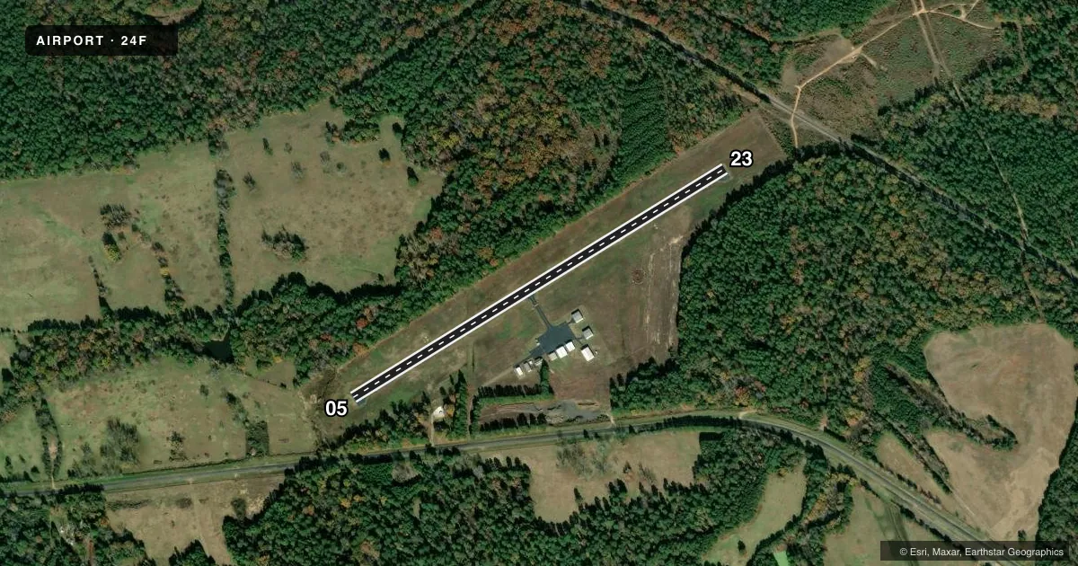
Runways & pattern
Full pagePattern entry · RWY 05
LEFT TRAFFICRunway end performance
| End | TORA | TODA | ASDA | LDA | VGSI | Approach lights | Obstruction |
|---|---|---|---|---|---|---|---|
| 05 | — | — | — | — | PAPI 2-box left(3.5°) | — | 120', trees, 2400' from thr, 690' R of cntrln, slope 18 |
| 23 | — | — | — | — | PAPI 2-box left(3.5°) | — | 93', trees, 2275' from thr, 650' R of cntrln, slope 22 |
Declared distances in feet. TORA = takeoff run available, TODA = takeoff distance, ASDA = accelerate-stop, LDA = landing distance.
Airport sketch
Runways drawn to scale from FAA survey coordinates, rendered over satellite imagery. Not for navigation.
Approaches & charts
Services on the field
Fuel grades, oxygen, maintenance, ramp storage and lighting — as declared to the FAA by the airport operator.
Fuel & services
- Fuel
- 100LL
- Oxygen (bottled)
- Not available
- Oxygen (bulk)
- Not available
- Airframe repair
- Not available
- Power plant repair
- Not available
Ramp & ground
- Transient storage
- Tie-down
- Hangar
- Landing fee
- No fee published
- Customs
- Not available
- Lighting schedule
- SS-SR
- Beacon schedule
- SS-SR
- Beacon
- White / Green (civil land)(WG)
- Wind indicator
- Lighted
- Segmented circle
- No
Fuel & FBOs
Cheapest 100LL and Jet A on the field and nearby. Always confirm with the FBO before taxi.
Airport notes
Surface conditions, obstructions, local procedures, lighting outages and other notes published with each FAA cycle.
General notes
- BIRDS & DEER ON & INVOF ARPT.
- FOR CD CTC FORT WORTH ARTCC AT 817-858-7584.
- TO ARRANGE COURTESY CAR CALL 903-240-7707 MON-FRI 0800-1700.
Fuel notes
- 100LL24 HR SELF SERV.
Approach & departure obstructions
- 05UNUSBL BYD 9 DEG LEFT OF RCL.
- 23UNUSBL BYD 7 DEG LEFT OF RCL.
Other notes
- OWNERALSO 906-665-8336 SANDRA WRIGHT ADMIN ASST TO CO JUDGE & CO COMM.
VFR map & nearby airports
VFR sectional. Tap any ICAO chip to open that airport.
Key facts · 24F
Answer card- ICAO
- 24F
- Name
- CYPRESS RIVER
- Location
- JEFFERSON, TEXAS
- Elevation
- 221.6 ft MSL
- Traffic pattern altitude
- 1,221.6 ft MSL (1,000 AGL)
- Control tower
- Non-towered (use CTAF)
- Total runways
- 1
- Longest runway
- 05/23 · 3,200 ft
- Published ILS approaches
- 0
- Published frequencies
- 1
- Magnetic variation
- 5°
- Current flight rules
- VFR
- Current wind
- 000° at 0 kt
- Favored runway now
- –
Cypress River Airport (24F) sits in Jefferson, Texas. Field elevation is 221.6 ft MSL. The airport has one runway. Runway 05/23 is 3,200 ft long on asphalt. There is no control tower. CTAF is 122.9. No ILS approaches are published here.
Pattern altitude is not published. For light piston traffic, use 1,000 ft AGL unless the current Chart Supplement says otherwise. The field is a simple setup, but there are a few things to watch. 100LL is available 24 hours self service. Bird and deer activity is published for the airport. The visual glide slope indicator on runway 05 is unusable beyond 9 degrees left of centerline. On runway 23, the visual glide slope indicator is unusable beyond 7 degrees left of centerline.
There is no on-field FBO listed. If you need ground support or a courtesy car, call ahead. The published courtesy car number is 903-240-7707, Monday through Friday from 0800 to 1700. For clearance delivery, contact Fort Worth ARTCC at 817-858-7584. If you are planning a first trip in, keep an eye on wildlife. Verify the current pattern setup. Use the current Chart Supplement for any updated local procedures.